


| 5 December 2004 | 1500m above Pheasant Creek | Photos | |
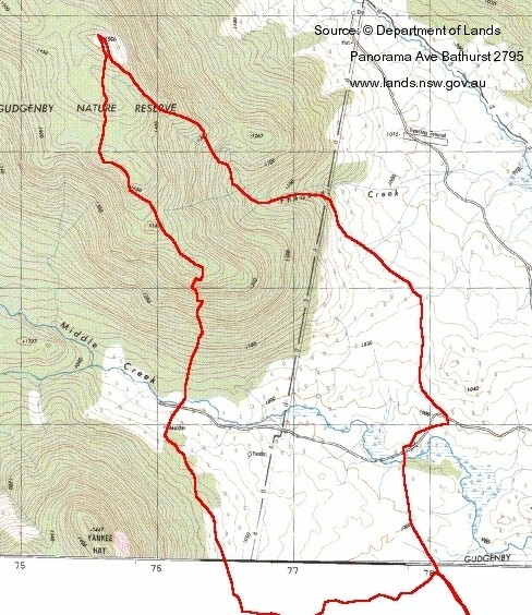
| Maps: Rendezvous Creek 8626-1S Second Edition 1:25000, Yaouk 8626-2N Second Edition 1:25000, map fragment | |||
| Getting There
I did this solo walk on the suggestion of a friend. It was probably the hardest climb of the year and, with the wild dogs howling, the thunder rolling around the hills and the hail falling, a little tense at times. Drive from Weston Creek via the southern suburbs through Tharwa, past the Glendale Crossing area. Turn right into Old Boboyan Road just before the end of the made road. It's signposted to Yankee Hat Car Park. The last 3.5km are unsealed. A total of 57.5km, about 1 hour's drive. |
| Walk
I started walking from the Boboyan Pines car park at 7.10am and headed along the familiar Yankee Hat Aboriginal Rock Art Track in brilliant sunshine. This walk over the little wooden bridge spanning Bogong Creek and the kangaroo-mown grasslands is always very pretty. My first bound was to the big boulder on the left and just short of the aboriginal art. My second bound was to another prominent boulder (marked on the map) to the NNW, just short of Middle Creek. I crossed Middle Creek at 8.20am and the climb began in earnest. Going up, views opened out across to Yankee Hat 1 and down to the Gudgenby Valley. It was here I heard the wild dog/dingo howl. The scrub was thick and, in places, the rock had to be scrambled up on hands and knees, or else skirted around to a navigable climb. Some hard going. I reached the first part of the spur at GR763441 (GDA94) at 9.30am. The going was a little easier as I followed the ridge up through spot height 1411and on up to the objective at spot height 1506. Great rock formations, wild flowers and dense bands of burned black and bare scrub. The top was marked by a little cairn which I reached at 11am. Magnificent 360 degree views from the barren top. The weather was deteriorating, so I only stopped to take a 360 degree sweep of 17 photos. I headed down Pheasant Creek to get off the hill as quickly as I could. I saw my first lyre bird in the wild. With thunder enhanced by the acoustics of mountain and valley and hail at times, I was glad to reach the edge of the Gudgenby Valley by 12.15pm. 2hrs40mins to go up, 1hr15mins to come down! There was then a 4.4km stroll across the grasslands back to the car, which I reached at 1.10pm. I had lunch and a couple of cups of coffee. I probably would not have persisted on this walk without a fly net! Distance: 14.4km Time: 7.10am-1.10pm, with stops to regain breath and take photos. |
|
|
|
| 1 Yankee Hat 1 and start of Mavis Ridge | 2 Balancing rock | 3 View from top South to Mt Gudgenby |