


| 9 February 2005 | Vanitys Crossing and Pipeline Road | Photos | Scroll down to map fragment |
| Maps: Cotter Dam 8627-2N Second Edition 1:25000 | |||
| Getting There
This walk was organised as a Wednesday walk by the combined CBC/FBI/NPA clubs, led by Allan M:
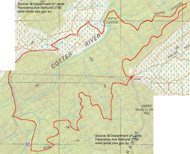
28 of us walked. We met at Cooleman Court at 8.30am and drove via the Cotter, along Paddys River Road. Directly east of Sugarloaf Hill, we turned right into Laurel Camp Road. After around 1 km we turned right onto a forest trail which took us just north of west, across Pierces Creek, to Pipeline Road. Then up the steep pinch to plenty of parking at the locked gate. About 30 minutes. |
| Walk
We climbed over the gate and took the trail looping NW, N, then NE. It was actually the pipeline maintenance track, as we came to and inspected the first of several air release valves after descending a steep pinch. With views to the cleared and bare Condor Hill and glimpses down onto the Cotter River, we met Vanitys Crossing Road and followed it south-west down to Vanitys Crossing. A few grass trees, with 2.5m spears, along the way. Some chose to rock-hop over the sluice and walk the concrete edge of the ford and others chose to wade across the foot deep water of the crossing, but we were soon out into the cleared forest area again. Blackberries at the side of the road provided an on-the-spot taste and, for others prepared to stop and pick the little berries, supplies for a pie or jam. Grand signage announced that we'd arrived at the intersection of Vanitys Crossing Rd, Vanity Rd and Yellow Rabbit Rd. We turned left at the junction, skirted to the west of the 800m hill feature (passing a rolled, abandoned car along the way) and so to our second crossing of the Cotter and lunch. Interestingly, the second edition map does not show the trails on each side of the river crossing as meeting, whereas the first edition map has a continuous trail. A beautiful pool, with running water at each end, made a great lunch spot. Then up a steep-ish pinch to rejoin the Pipeline Road. Easy walking on the wide road as it constantly (but reasonably) rose out of the river valley back up to the ridge line and, finally, the gate and cars. A nice little walk in an area I'd not seen before. Distance: 11.9km Time: 9.10am-2.10pm, with 1 hour 20 minutes of stops. |
|
|
|
| 1 Bare hills | 2 Vanitys Crossing | 3 Second Cotter River crossing |
 |