


| 19 February 2005 | Mt Coree and Coree Falls | Photos | |
| Maps: Cotter Dam 8627-2N Second Edition 1:25000 | |||
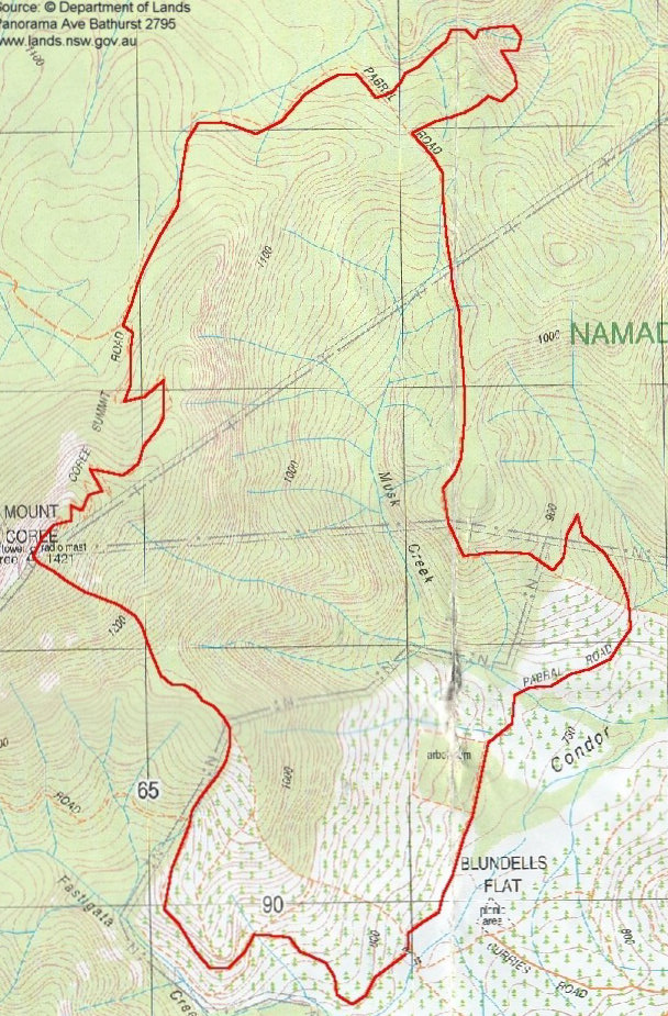
| Getting There
Drive to the Cotter, turning right into Brindabella Road. Left at the T-intersection and head towards Piccadilly Circus. Just past the end of the made road, turn right into Curries Road. Drive a further around 2km on the dirt, left at the intersection which says Blundells Flats picnic area is closed and across the ford on Fastigata Creek. Park at the intersection of Curries Road and Pabral Road. Around 45 minutes from Weston Creek. I did this walk with Max S, who I met on 5 Jan 05. He is certainly several notches fitter than I am! |
| Walk
The Mt Coree walk is number 1 in Graeme Barrow's Exploring Namadgi & Tidbinbilla: Day walks in Canberra's high country and number 2 in Graeme Barrow's Namadgi and Tidbinbilla Classics: Tough Bushwalks in Canberra's High Country and Coree Falls is number 1 in the same publication. We were walking by 7.10am through sad, burnt out but still standing pines each side of Curries Road. 10 minutes saw us at the 5-ways intersection and we dutifully took the second on the left, as described by Graeme Barrow. There were views down into Fastigata Creek, ahead to the saddle where Curries Road meets Two Sticks Road and we'd begun our 5 Jan 05 walk, and further right to the 'nose' of the cliffs on the southern end of Mt Coree. Around 7.30am we headed just east of north up the 'arduous climb of 150m', the boundary between the burnt and cleared pines and the burnt and recovering native forest. The fire trail had disintegrated into a steep gravel wash. Marvellous views to the western side of Tidbinbilla ridge, with Pierce Trig, Camels Hump, Johns Peak, Tidbinbilla Peak and the distinctive western flank of Tidbinbilla Mountain clearly discernable. 23 minutes to climb the 0.75 km and 190 m up to the 'corner' of the native trees and ex-pine forest. We went bush at this point, enjoying a brief respite as the ground saddled and actually fell a metre or two. We then just headed vaguely north-west to the top, the route described by Barrow as ' ... punishing in its severity'. It was (with worse to come!). The fire tower, trig and radio mast came into view just before 9am and we enjoyed the vista for 20 minutes. Quite spectacular, particularly west and north-west into NSW. Soon after arriving, a head appeared from the east - an extremely fit English gentleman running up Mt Coree (and it wasn't yet a sunny noon!). We then headed down the Coree Summit Road, swinging right into the signposted Pabral Road. After around 3km and at 10am and GR659931 (GDA94) we again went bush, heading north-east to Coree Creek and the falls. A lyre bird was heard calling and briefly spotted. A steep descent took us to a small waterfall where we lunched for 30 minutes. Max was not satisfied that we were at Coree Falls (even though I'd told him I don't enjoy heights or water) and I'm glad he suggested we persist following down the creek. We soon came to the top of the falls and spent some time skirting them on the northern bank of the very steep gully, then back upstream to the foot of the falls. Quite spectacular! We crossed to the southern side of the creek and began an extremely arduous climb out of the gully. It took 42 minutes to travel 350m and 130m up, over loose rocks hidden under ferns and blackberries. Being a ¼ of an aspirin a day taker to keep my blood thin, I was a scratched and bleeding, sweating, panting, half-dead mess, tingling with nettle stings for hours after. Gentlemanly Max waited patiently for me. We were back on Pabral Road just before midday and wandered the 4.5km back to the car, reaching it at just before 1pm. An excellent walk, the toughest I've done to date. Distance: 12.6km Time: 7.10am-1.00pm, with 50 minutes of stops and many pauses for me to restart breathing. |
|
|
|
| 1View NW from Mt Coree | 2 Coree Falls | 3 Coree Falls from the side of the gully |
 |