9-10 April 2005 KNP - Main Range Track including Mt Twynam, Lake Albina, Alice Rawson Peak and Mt Kosciuszko Photos Map fragment
Maps: Mount Koscuiszko 8525S
Getting There

This walk was a CBC walk led by Gloria M, with assistance from Lauraine R.  7 of us walked.  It was my introduction to KNP.  The walk displayed both the beauty of the area and a reminder to respect the weather.  We left Canberra at 6.15am and drove via Cooma and Jindabyne to Charlottes Pass.

Walk

Saturday.  Charlottes Pass to Alice Rawson Peak.

We parked along the road and were walking by just after 9.30am.  It was a blue-sky-and-cottonball-cloud day, so there were plenty of overnight and day walkers setting out.  The start of the track, although not exactly 'streets paved in gold', was certainly paved like my backyard.  It must get lots of traffic.  Down the hill to the evocative crossing of the Snowy River, with beautiful views of the Snowy River coming down on the left, Club Lake Creek in the centre and the Main Range Track winding up the right side.  We dropped our packs and took a quick side trip to the hut ruins (just the chimney standing) to the west - it's Foreman's Hut ruin.

Then on up the track at a good pace to Blue Lake lookout, with views up to Mt Twynam and down to Headley Tarn.  We passed many walkers - a bit like Pitt St.  We reached the lookout at 11.15am and stopped for 25 minutes.  Another hut ruin (nothing standing) just down from the lookout was inspected - it's Blue Lake Shelter ruin.

We continued on for another 450 metres to a lovely grassy gully where we left the main track, and our packs, and headed NNE up it to join the Mt Twynam track.  It was interesting to see all the evidence of old vegetation recovery work - heaps of pickets in the ground which would have anchored wire mesh to encourage regrowth.  Great views as we walked the track to the rugged ranges in the west (plenty of smoke haze as landholders burnt off), to Mt Townsend in the south-west and our objective.  The open and treeless alpine country was quite different to the scrub-bashing I'm used to.  12.30pm saw us at the trig at Mt Twynam, where I 'bagged' Australia's third highest peak!  We spent 15 minutes admiring the astounding view south to Mt Koscuiszko.

The notable feature on the return leg to our packs was the razor sharp ridge out to Mt Sentinel.  30 minutes of lunch was enjoyed, as yet more walkers passed us enjoying the day.

At 1.45pm we shouldered packs and headed along the Main Range Track.  2.20pm saw us at Carruthers Peak.  We looked back to see a large party at the main track/Mt Twynam track junction and, a little further on, down to Club Lake.

We continued along the track, passing a track workers' shelter dome near Mt Lee.  At 2.50pm and GR148686 (GDA94), we left the track and headed down the beautiful grassy slope to Lake Albina.  It must look a picture when the wildflowers are out. We stopped for 30 minutes to get water for the night's high camp and to have a bite of arvo tea.  The lake drains down into Lady Northcotes Canyon - impressively wild.  Challenging enough, however, was the view to the west - to Abbott Ridge where Lauraine knew there to be a lovely campsite at Alice Rawson Peak.

It took 50 minutes to climb the 1.12km to the ridge line, gaining 250 metres and lugging an extra 2 litres of water.  A couple of stops to regain breath, but relatively easy going over the alpine vegetation.  Certainly no scrub-bashing required here.

Another 10 minutes saw us at the camp site, at just after 4.30pm.  A beautiful grassy area on Alice Rawson Peak, altitude 2176m, tucked in on the eastern side of the granite tors out of the prevailing wind.  GR132688 (GDA94).

We set up camp, had tea (including a bottle of port to share around), then a couple of us went over the ridge to watch the sun set.  With the smoke from burning off turning the sun into a massive red ball, it was a spectacular sight.  In bed by 7.30pm!

Distance: 14.9km  Time: 9.30 - 4.30pm with 1 hour 40 minutes of stops.

1 Mt Kosciuszko from near Carruthers Peak 2 Lake Albina 3 Sunset from Alice Rawson Peak

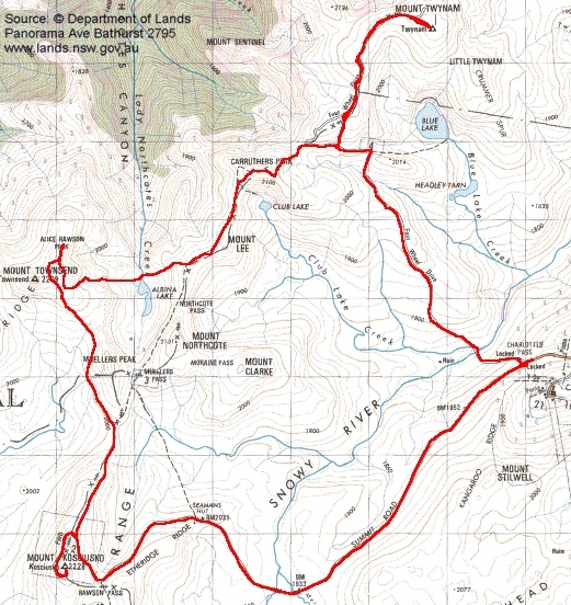
Sunday.  Alice Rawson Peak via Mt Kosciuszko to Charlottes Pass.

The wind built during the night and gave the tent a good shaking.  But it was warm and dry.  A spectacular sunrise at 6am, with glowering clouds and dark ridges framing a slit of vivid red sunlight.  From the comfort of my sleeping bag I watched the cloud swirl in from behind until its base was below us.  Not a good day for mountain peak views.

I breakfasted in bed.  We were packed and ready to go as planned by 8.30am, but waited 30 minutes to see if the cloud would lift.  No luck, so Mt Townsend, Australia's second highest, had to be left on this occasion.

9am saw us setting out in the pea soup.  Heading back along the ridge, just west of south, we came across the Mt Townsend footpad in 10 minutes.  We followed this until we rejoined the Main Range Track.  At one stage we lost the footpad, but a pause and return to the last cairn soon found it again.

10am saw us back on the main 'highway', with visibility not improved at all.  By 10.30am we were at the junction with the Mt Koscuiszko track, having passed a ranger who was on the lookout for the large school party we'd seen yesterday.

4 of us left our packs and went on the 800 metres up to Mt Koscuiszko - I couldn't not 'bag' Australia's highest peak (2228m), even if nothing could be seen!  5 minutes was enough to experience the howling wind and swirling cloud, and to touch the cairn.

Back down, we retrieved our packs and met the others at Rawson Pass.  They'd measured the temperature at 8°C, but with the wind blowing at at least 50kph, it was more like -6°C.  A ranger was on duty at the Pass (sensibly sitting in a warm vehicle!).

After a 5 minute regroup, we quickly trudged the 1.7km to Seamans Hut.  A 45 minute lunch break was enjoyed, out of the wind and a bit of rain.

We left the hut at 12.30pm and pounded the Summit Road the 6km back to Charlottes Pass, arriving at 1.45pm.  Although the cloud lifted by the Snowy River bridge, it still hung on Kangaroo Ridge and Mt Stillwell, so there was no point in going up there.

Distance:  14.4km  Time: 9am - 1.45pm with 55 minutes of breaks.

4 Sunrise and cloud at Alice Rawson Peak camp site 5 Mt Townsend track 6 Snow gum

We stopped in Cooma on the way back for a bite to eat and drink.

A fabulous experience for me!  Country I'd never been in before and a great opportunity to shake down my gear for an up-coming walk in Tasmania.  Very well organised and led and a great bunch of people.

Total Distance: 29.3km

Home

Top