


| 16 April 2005 | KNP - Mt Stilwell and Kangaroo Ridge | Photos | Map fragment |
| Maps: Mount Koscuiszko 8525S | |||
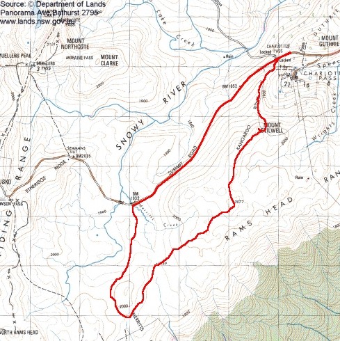
| Getting There
This walk was a CBC walk led by Ross A. 5 of us walked. It was my second walk in KNP. A lovely day walking through alpine grasslands, tors and tarns. We left Canberra at 6.20am and drove via Cooma and Jindabyne to Charlottes Pass. |
| Walk
We parked along the road and were walking by 9am. Blue skies smeared with cloud and a 'lazy' breeze (goes through you, not round!). From just on the left of the toilet, we set off up the track, then footpad, to Mt Stilwell, passing the tops of the current and old chairlifts from Charlottes Pass. Someone (eagle, falcon?) had carted some very large sticks into one of the chairlift towers to make a comfortable nest. The Mt Stilwell trig was well in view and we made it in 50 minutes and spent 15 minutes admiring the view. From there, we wandered (under careful leadership - I can only imagine what it must be like under cloud or snow) SW along Kangaroo Ridge to a white marker pole stuck in the top of a tor at GR184655 (GDA94). An interesting feature with a rock tunnel under. We stopped here for 5 minutes. Next bound was SSW to spot height 2077. We found a picture perfect spot in the lea of the tor to have a bite for morning tea. 20 minutes was spent fortifying body and soul with fresh air, wonderful views and a little sustenance. Next stop was a really groovy cairn at GR177639 (GDA94). Like many of the tors, it had an impressively steep presentation, but an easy ramp up another side. I hope I did the right thing by adding another rock to it. We spent 5 minutes here. Onwards SW through an area of small tarns, with views to North Rams Head and Summit Road to Seamans Hut. Ross was wanting to visit (and found for us) a lovely tarn at around GR166630 (GDA94) (marked on second edition 1:25000 map, but not first). There were thoughts of heading for the Crackenback chairlift cafe for a coffee, but real walkers don't do that. Instead, we found a most beautiful little creek with waterfalls and pools at GR160621 (GDA94), where we propped for lunch for 35 minutes. I'd brought my 'modified H...field cooker', so made a nice cup of (instant) coffee to go with lunch. We then headed north, between the Snowy River and Merritts Creek, to the Summit Road at the bridge. Then a tramp along the Summit Road back to Charlottes Pass, which we reached at 2.30pm. An excellent walk. Fortunate to be able to walk the exact area proposed last Sunday. Total Distance: 15.8km Time: 9.00am - 2.30pm with 1 hour 20 minutes of stops. |
|
|
|
| 1 Mt Stilwell from track from Charlottes Pass | 2 Rock tunnel on Kangaroo Ridge | 3 Alpine tarn and Etheridge Ridge |
 |