23 April - 1 May 2005 Walls of Jerusalem, Highland Lakes, Cathedral Plateau, Mersey River Falls, Overland Track and Lees Paddocks Track, Tasmania Photos
Maps: Walls of Jerusalem 1:25000; Cradle Mountain - Lake St Clair 1:100000; Cradle Mountain Lake St Clair and Walls of Jerusalem National Parks by John Chapman and John Siseman; The Overland Track - A Walkers Notebook Tasmania Parks and Wildlife Service
Getting There

I did this walk as a participant in a CBC trip organised and led by Rupert B.  5 of us walked – RB, BE, JW, J O’H and myself.  If I had known all that we were to face, I probably would not have gone; if I had not gone, I would have missed an experience of a lifetime.  There are insufficient superlatives to describe what we saw and did.

This was my first experience of an 8 day, unsupported, on and off track walk in extreme conditions.  I learned many lessons.

I flew from Canberra via Melbourne to Devonport with 2 other adventurers, where we met Rupert and Bob with their cars.

Walk

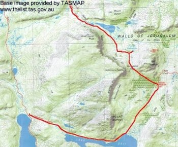
Day 1 - 23 April.  Canberra to Wild Dog Creek

We drove from Devonport via Sheffield (last coffee and pie for several days) to the Walls of Jerusalem car park.

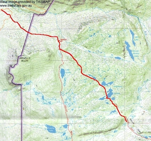
At 1.15pm 3 of us started to walk whilst the others took a car to the exit point some 7km away.  The walk register was signed and the track (steep in parts) took us up through eucalypt forest.  My first lesson came early – my pack weighed in at 24.9kgm at Canberra airport and I now had an additional 1 litre of Shellite and a ham and salad roll on board.  2.20pm saw us pausing at Trappers Hut, along with at least 8 other walkers.  The worst of the up was now over and by 3.05pm we were at the first of the magical tarns collectively called Solomons Jewels, fringed with patches of Pencil Pines.  Even under the threatening cloud/fog they looked beautiful – typical Tasmanian alpine vista, but far surpassing what I had imagined.  By 3.45pm we had crossed the boggy drainage line and were at the Wild Dog Creek camping site, where we waited for an hour for the others to join us. 

With the tops of King Davids Peak and other heights hidden from view, the decision was made to occupy the tent platforms for the night.  In addition, camping within the Walls area is discouraged.  As well as our party of 5, 14 others stayed the night here.

Several more lessons followed in quick succession for this ‘newbie’.  Efficient tent pitching was one and I was grateful for assistance (I did get better); then what seemed like a reasonable sized meal when test prepared at home turned out to be enough for 2 meals; and, after unpacking and repacking various stuff sacks several times, the lesson of ‘a place for everything and everything in its place’.

In bed by 6pm, with overcast skies bringing showers during the night.

Distance: 6.0km  Time: 1.15pm – 3.45pm = 2.5hrs, including a few photo stops

01 Trappers Hut
02 Solomons Jewels
03 Cushion Plant by Walls of Jerusalem Track

_______________________________________________________________

Day 2 - 24 April.  Wild Dog Creek to Lake Meston

The day began with a routine similar to most – up at 6.30am, dress, breakfast and pack up and ready to start walking by 8am.  Unfortunately the cloud still hung low and it was obvious that the biblically named peaks and most of the features of the Walls of Jerusalem would have to wait for another time.

We pressed on up through Herods Gate and passed Lake Salome.  There was plenty of time to admire the views as, after my quick photo snaps, we waited for RB to compose and capture his photos (he is an excellent photographer and his shots will be superb).

There was a 50 metre detour from the hardened track to the Pool of Bethesda, a picturesque little tarn.  Even in the cloud and fog it was a beautiful sight.  A couple was camping close by.

Then on through the ancient Pencil Pine forest to Dixons Kingdom Hut by 9.35am.  A wonderful log and shingle structure squatting at the edge of the forest.  Morning tea was enjoyed sitting inside out of the cold and wind.

At 10am we left the ease of the hardened track and headed into ‘the wilds’.  A step of faith from security to the unknown for me, but no doubt a welcome relief to be away from tracks and other walkers for the rest of the party.  RB’s navigation is superb – an easy synergy of map and compass, reading the land and ‘feel’ from previous trips from right back as a Boy Scout.  We headed first along an animal pad down a creek, then over a ridge and through pine scrub down to the swampy end of Lake Ball.  By 10.40am we had joined the end of the Lake Ball Track.

Within minutes we were walking through the first patches of Fagus, Tasmania’s deciduous beech which turns golden leafed in autumn; seeing it was one of the objectives of the trip.  There was a marvellous strip of it for several hundred metres, leading us to and beyond Lake Ball Hut, which we reached at 11am.  We had a good explore around the Hut and down to the lake shore and left the area at 11.20am.

By 12 noon we were at the top of the creek flowing into the western end of Lake Ball and 15 minutes later saw us over the ridge and down the other side through eucalypts on the track to Lake Adelaide.  The sun appeared briefly.

Lunch was taken in the shelter of the trees at the northern end of Lake Adelaide.  The lesson to be learned here was that one should prepare one’s lunch at breakfast time and have it handy, rather than rat through and empty out the entire food larder to find the required items.

At 1pm we set off down the eastern side of Lake Adelaide on the Junction Lake Track.   It took an hour and a half to complete this leg, including climbing up and around a huge rock shelf which juts into the Lake and kinks the track about half way along.

From the southern end of Lake Adelaide we continued on the boggy track to Lake Meston.  We were expecting foul weather, so had tents up by 4pm at GR371627 (AGD66) and my main meal cooked before the rain started.  But I didn’t want to set fire to my tent by running my liquid fuel stove near the vestibule to boil water for the night’s coffee bag.  Lesson: there are extra advantages in a slow, low burning alcohol stove – lie in bed and make a cuppa close to your tent in inclement weather.  A few leeches appeared and, after the initial ‘ugh’, we were soon expert rollers and flickers of the little suckers.

I began to think that I’d have to carry my litre of port to share for yet another day, but the rain stopped at 7pm and so I did a delivery of said liquid refreshment to 4 of the 5 tents.  To bed at 7.15pm, later waking first at 12.15am then 3.15am thinking it must be time to get up.  Very ‘healthy, wealthy and wise’ making.

Distance:  14.6 km   Time: 8am – 3.30pm = 7.5hrs, including 1.5hrs of breaks and many photo stops
04 Pool of Bethesda
05 Fagus at Lake Ball
06 Root and rock between Lakes Ball and Adelaide

____________________________________________

________________

Day 3 - 25 April.  Lake Meston to Cloister Lagoon

I was up at 6.15am, finding that I needed more time to get organised than the others.  Surprisingly, my socks were not too wet.  However, I did feel a bit crook (as I did early in the first days of my November trip to Tasmania), so popped a paracetamol and only had half my breakfast.  I ensured that I kept my water intake up.

We left at 8.15am and by 9.05am were at Lake Meston Hut, having passed through more stands of Fagus.  We stopped for 20 minutes to admire the hut and surrounding scenery, then took the northerly track towards Lake Myrtle.  We stopped again around 10.50am for photos back to the Walls of Jerusalem to the northeast.  Views to Mount Rogoona began to open up in the southwest.  The temperature was around 8°C, not accounting for wind chill factor.

We reached Lake Myrtle by 11am.  Mount Rogoona reared above the southeast lake shore.  We left at 11.15am and headed along the track towards Lake Bill for 500m.  Then left into the scrub and a stiff climb up the ridge.  The going was a little more open up the top, as we headed a little south of west as the lie of the land allowed.  We took a 30 minute break for lunch.

Our track led us up through stands of bushfire burnt pines, bleached white and standing starkly like a field of thousands of giant crosses.  Behind was the blue-grey of Lake Myrtle and the scree slopes of Mount Rogoona.  We eventually arrived at the edge of a steep valley holding Cloister Lagoon and Moses Creek.  It was 100m down in a very short horizontal distance with boulders, trees and belts of thick scrub to force through - I'd not tackled anything like that before.  I was certainly glad not to have leadership or navigation responsibilities, and very happy to walk 'tail end Charlie' following the way forced through the thick scrub by 4 others.

We were thankfully down by 3pm and met the track running down the valley (from Junction Lake to the Mersey Forest Road).  We propped for a while whilst Rupert searched for a track up out of the valley on the western side to the Cathedral Plateau, but no luck.  So we decided to stay for the night.  We were all grateful to JO'H, who stood knee deep in the creek and passed our packs across to the other side where there was better camping, about 300m north of Cloister Lagoon.

Had a leisurely tea, accompanied by misty rain, passed round the rest of the port and was in bed by 6pm.  I was very disappointed by the performance of the expensive 3135 mAh batteries I'd purchased for my gear, having to change 4 in the camera during the day after only 120 shots.  Of more concern was their performance in the GPS - I'd taken only 2 position fixes and the battery power was already showing less than half.  I slept with the camera for the rest of the time and that improved things; thank goodness we didn't have to rely on the GPS when it came time to descend from the Cathedral Plateau.

Distance: 7.7km  Time: 8.15am - 3pm = 6.75hrs, including 1.5hrs of breaks and many photo stops

07 Lake Meston
08 Mount Rogoona and Lake Myrtle
09 Looking down to near Cloister Lagoon

_____________________________________________________________________

Day 4 - 26 April.  Rest Day at Cloister Lagoon/Exit

By this stage we had looped south and west to be within 6km on track to the second car.  JO'H was suffering from a bad knee and made the difficult, yet correct, decision to exit.  He didn't want to hold the rest of us up.  So he and the other 2 guys walked out, taking with them a few kilograms of my excess food (someone knew what was to come!).

We remaining 2 spent a quiet day in camp.  We first walked south along the track to Cloister Lagoon, then I headed north towards Grail Falls and Chapter Lake.  I went into a hole up to my thigh, lost my pocket knife (lesson: use the zip on the pocket), missed a turn in the track and spent 45 minutes crawling through dank scrub by the sides of the lagoons and pools.  I found the track on the return leg, which took 10 minutes.

A lone walker passed by around 11.30am, on his way back to Deloraine after meeting Hobart friends at The Labryinth.  Oh to live in Tasmania!

A little sock washing, talking and dozing filled the day till RB and BE returned.  A lovely clear sky day.  In bed at 5.40pm (well, what else is there to do?).  A cold night.

Distance: 2.6km

10 Cloister Lagoon 11 Mountain Rocket 12 Dank scrub
_______________________________________________________________________________________

Day 5 - 27 April.  Cloister Lagoon to Cathedral Plateau

It was a crystal clear morning at 6am when I rose, still full moon bright.  By 8am it was -2°C and this was to be the most strenuous and wonderful day's bushwalking I'd ever experienced (until the next day!).

With no clear pad up out of the valley, we found a cleared area which took us to the tree line, then just went up - around 120m in a similar horizontal distance.  It was either extreme scrub bashing or 4 point contact pulling ourselves up vegetation lines through the cliff-like boulders.  At one stage I could go no further with my pack on and gratefully accepted a haul of it a few metres up a vertical patch.  It took 1 and a half hours to reach the top.

We set off from morning tea at 10.35am, with Chalice Lake soon coming into view.  Another blue sky day, with wonderful views back the where we'd come from and across to where we were going.  The vegetation on the Cathedral Plateau was more open, plenty of lakes and tarns, ups and downs and contour walking.

Lunch was taken at 12 noon, with plenty of time to recover from the strenuous climb at the beginning of the day.  We all lay on the warm rocks like lizards.

By 3pm we were at the edge of Cathedral Plateau, a GPS check indicating that Rupert had navigated us to within metres of where he wanted to be.  The peak of Cathedral Mountain no doubt beckoned RB and BE, but we others were happy to prop for the night.

The views were magnificent!  From my campsite on a soft bed of horizontal Creeping Pine (more like a waterbed, with a running soak just a metre from my tent) I could look northeast across a golden edged sparkling blue tarn to the plateau we'd traversed.  Very tranquil.  A walk of 50m to the west brought into view the awesome mountains of the Du Cane Range and Mt Ossa across the 700m drop into the Mersey River valley, with the southern cliff of Cathedral Mountain nearby.  Spectacularly rugged.  To bed by 6pm.

Distance: 4.1km  Time: 8.15am - 3pm = 6.75hrs, including 2.5hrs of breaks and many photo stops

13 Near vertical climb out of Cloister Lagoon
14 Edge of Cathedral Plateau
15 Evening view from campsite

__________________________________________________

Day 6 - 28 April.  Cathedral Plateau to Kia Ora Hut

It was a beautiful, clear, moonlight night again and we were up before 6am to get ready and enjoy the sunrise to the east and brooding mountains in a sea of swirling cloud to the west.

We began our descent at 8am on 210°M, not as steep as around Cloister Lagoon, but certainly more spectacular in terms of the vegetation and surrounding mountains.  It was a lot wetter as we pushed through beech myrtle and pandani forest.

By 10am Fergusson Falls was in sight through the trees, Rupert unerringly navigating us there from amongst the number of falls stretching from Hartnett Falls to Cathedral Falls.  My heart rate rose as I knew the next challenge was soon to be faced.  Not liking either heights or water, the crossing of the Mersey River gorge on a rock bridge several metres above the foaming chasm was building in my mind.  However, there was no other way.

Brightly coloured mushrooms and fungi provided a diversion and we spent quite some time photographing them.  Blue, red, purple and orange in colour; mushroom, coral and plate shapes.  The diversity and beauty in these micro realms challenged the awesome mountains.

However, we had to move on and so we climbed down the last few metres to the rock bridge - keystones lodged in the top of the gorge.  The others skipped across but I happened to look down through a hole framed in tree roots at the start of the crossing.  I backed off, raised my gaze (and game) and crossed!  Now I'd experienced what I'd seen last November from the Overland Track side of Fergusson Falls.

We explored around Fergusson Falls, then went to D'Alton Falls.  We then joined the Overland Track and went to Du Cane Hut for lunch.  The weather was beginning to close in again (forecasts of rain, high winds and snow for the next 3 days), so thoughts of climbing Castle Crag had to go.

We reached Kia Ora Hut by 2pm, after passing nearly 20 walkers going south towards Lake St Clair.  We went down to Kia Ora Falls and walked around the hut precinct, but were happy to stay in the hut with the deteriorating weather.  After the tranquillity of camping, it was a noisy night shared with 9 in and 7 outside on the platforms (they did get wet).  Bed, as usual, by 6pm.  The evening's lesson learned was the value of ear plugs.

Distance: 7.3km  Time: 8am - 2pm = 6hrs, including 2.5hrs of breaks and many photo stops

16 Sunrise from Cathedral Plateau
17 Mountains in a sea of cloud
18 Rock bridge across the Mersey River

______________________________________________________

Day 7 - 29 April.  Kia Ora Hut to New Pelion Hut

The wind howled and the rain pelted during the night.  But we also woke to a dusting of snow, with more falling during the day to give us a winter wonderland in autumn.  Quite a new experience for me, having only done a day walk near Canberra in some snow and a little on one morning last November.

We had a slow start, as there could be no expectation of climbing Mt Ossa.  We were on the track by 9.15am, wearing an extra layer for warmth and (all but Rupert) waterproof trousers.  Plenty of snow and wind as we climbed to Pelion Gap and paused briefly for a group photo.  Mt Pelion East, which I'd climbed last November, was white-capped.  Only passed one walker today, a little different to yesterday (we read later in the hut log that he had the New Pelion Hut palace to himself).

Then down the other side from the Gap into a bit of forest shelter.  Side trip to the falls on the Douglas Creek.

We were at New Pelion Hut around 12.30pm.  We pulled down the divider shutter and lit the gas fire, as it was certainly less than 10°C.

A couple of us walked to Old Pelion Hut, then up Douglas Creek and back over the Pelion Plains to the hut.  5 other walkers had arrived and we had a cosy environment for good conversation.  In bed by 6pm, but feeling spoilt by the nights in the huts.

Distance: 11.2km  Time: 9.15am - 12.30pm, 2pm - 4pm = 5.25hrs, including plenty of breaks and dawdling

19 Mt Doris and Mt Ossa
20 Cream fungus
21 Mt Oakleigh

___________________________________________

Day 8 - 30 April.  New Pelion Hut to Devonport

It was a windy and rainy night, with mist and rain continuing all the day.  The initial plan was to walk the Lees Paddocks Track to an hour or so short of the exit car and camp overnight but, as the rain continued, talk of BE's brother offering us hospitality for the night sounded better and better.

We left the hut at 8.15am and sped along the well maintained planks of the Innes Track to Lake Ayr.  In less than an hour we branched right onto the Lees Paddocks Track and were passing Reedy Lake.  The leeches were loving us and at each stop we'd find plenty on each other.  As we headed towards the World Heritage Area exclusions the track wound down through myrtle forest high above a raging stream.  Wet and leechy, but very pretty.

11.05am saw us out of the forest at Lees Hut.  A private hut, with the door open to walkers (I rang the owner to thank him when I got back).  Full of incongruities - a hitching rail outside, but inside an inkjet picture of a huge leech; slow combustion stove made out of a steel beer keg.  Dean Bluff towered above in the mist and you could just imagine Cathedral Mountain in the distance as you looked up the valley.

We crossed the creek near the hut on a 2 plank and 1 handwire bridge and continued down the track to reach Pine Hut at 1.55pm.  A quick lunch was taken, as the rain was wet and civilisation was calling.  We walked down Pine Hut Plain to the beginning of Lake Rowallen, then back up to the last crossing of the Mersey, a substantial metal swing bridge with wired in sides.  A short up hill dash and we were out by 3.45pm.

We cleaned up a little, tried to leave most of the leeches behind and drove to Devonport.  Our trusty leader even knew an excellent cafe where they didn't look too strangely at us and served great monster burgers, chips and cappucinos.

On to BE's brother's home, where he and his wife welcomed us with genuine hospitality, cold beer, hot shower and soft bed.

Distance: 17.6km  Time: 8.15am - 3.45pm = 7.5hrs, with 1.5hrs of stops

22 Bridge over the Douglas River on the Innes Track
23 Pic of huge leech in Lees Hut
24 Lees Paddocks Track meets Mersey Forest Road - the end

________________________________________________________________________________________________________

Day 9 - 1 May.  Devonport to Canberra

A huge serve of bacon and eggs and coffee for breakfast; the morning spent trying to pack dirty and smelly gear; an earlier flight home, stopping to get chocolates for my favourite wife in Melbourne.

In summary:  This was, indeed, the trip of a lifetime.  I learned many lessons.  I left behind blood (courtesy of the leeches), sweat (some gigantic climbs and descents) and tears (that's of the flesh on shins, thighs, hands and arms; not salty liquid from the eyes).  I lost my pocket knife, sunglasses and 3.5kgm of body mass in the 8 day's walking.  I gained incredible experiences and lifetime memories.  Rupert's snow shoeing the Overland Track in July - who's coming ...?

Total Distance: 71.1km

Home