


| 13 June 2005 | Mt Domain to Tidbinbilla Peak | Photos | |
| Maps: Tidbinbilla 8627-2S Second Edition 1:25000 | |||
| Getting There
I did this walk with DB, a good mate. Any reader of this blog will know I love the Tidbinbilla skyline, seeing it each day as I walk to work. I'd previously walked Mt Domain at the south and Camels Hump to Tidbinbilla Peak in the north, but not the middle section. The Tidbinbilla Nature Reserve opening hours are 9am-5.30pm on a winter's public holiday and I was very pleased to find out that we could get in at 7.30am, when I rang on Sunday morning. L was very helpful and accommodating. Drive from Canberra via Point Hut Crossing to the Tidbinbilla Nature Reserve. We left one car at the trails car pack on drove on around the ring road to Fishing Gap car park. I thought it best to walk the ridge from south to north as, at any point from Snowy Corner north, we could exit off the ridge. |
| Walk
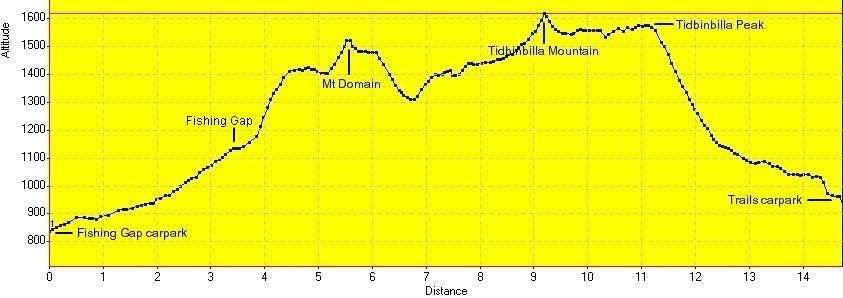
This walk includes number 4 and parts of number 3 in Graeme Barrow's Exploring Namadgi & Tidbinbilla: Day walks in Canberra's high country. We were walking by 7.45am (it takes a whole lot less time to organise a party of two). I must be getting fitter as, on my third time to Fishing Gap, the fire trail walk took 46 minutes. No time to stop at the gap, just a right turn and up the spur to the false top, on to spot height 1402, across the flat and up the final pinch to Mt Domain. The regrowth is certainly taking off, with bands of bracken and belts of gums to nearly head height in places. The growth was wet from the welcome rain the day before and clothing and boots were soon sodden. Reached Mt Domain at 9.45am, 30 minutes quicker than previously. It certainly wasn't a race - rather a long day's walk (planned to go to Camels Hump) and I thought it best to quickly negotiate the area I was familiar with. We took morning tea on the northern point of Mt Domain, with views west to (dry) Ginini Falls and north to the unknown (for me) central portion of the walk. We headed down from Mt Domain, then along the well defined ridge. Great views to the east and west. The ridge was quite narrow in places and rocky underfoot. The ridge took us down to a saddle between Mt Domain and Tidbinbilla Mountain, dropping from 1506 to about 1300 metres. There was nowhere to go but up again, through spot height 1431 and Snowy Corner. There were some tremendous drops off the ridge, particularly north and east from spot height 1431. Some great little knolls, too. The cloud lowered as we pushed up the final bit to Tidbinbilla Mountain at 1625 metres. It rolled in to obscure Tidbinbilla Peak to the north east and, to the SSW, we caught glimpses of Corin Dam through the breaks. Being a newbie in the area I wanted to keep moving so, even though we reached the Mountain at 12 noon, we only paused for 10 minutes. But the cloud lifted and we could see our next objective as we came off Tidbinbilla Mountain to the north east. Around this stage, one of the party had to confess that feet, boots and rocky terrain were not in harmonious relationship, so we took the foot off the gas and cruised slowly to spot height 1555 and paused for a few minutes. Magnificent views back around to The Pimple (must go there next time!) and to the western face of Tidbinbilla Peak. We reached Tidbinbilla Peak at 1.20pm and were grateful to be able to stop for lunch. I felt a little more confident being back on familiar territory from a previous walk. A pair of wedge-tailed eagles entertained us whilst we had a bite to eat and hot coffee. We'd decided to abandon the ridge further north, so after a 30 minute break we retraced to the marker cairn at spot height 1556 and headed south east down the spur to take us off the ridge. Probably more by luck than good navigation we kept a little further east than my previous exit (which had me crossing sad, thistled creeks) and hit the Camel Hump fire trail at GR717756 (AGD66). A wander down the fire trail had us at the car in the trails car park at 4.25pm. We drove round to the second car at Fishing Gap car park, completed our walk register entry, then drove to the visitors centre to thank the staff for their assistance. The rain started as we left the reserve. This would be the hardest and also the most spectacular day walk I've done to date. As well, bagged a peak and joined two previous walks. Distance: 14.8km Time: 7.45am - 16.25pm, with 1 hour of stops and a few restart breathing pauses. |
|
|
|
| 1Tidbinbilla Ridge north from Mt Domain | 2 Tidbinbilla Peak from spot height 1556 | 3 Zoom to The Pimple from Tidbinbilla Peak |
 |
|
Mt Domain to Tidbinbilla Peak track profile |