Having spent a year as a member of the Canberra Bushwalking Club and having several experienced members share their bushcraft with me, time came for me to put a little back in. So I offered to lead a walk. Not wanting to look like a complete idiot, I thought it best to do a recce. A mate, Max S, with whom I'd done a previous walk, kindly agreed to come with me. We left Canberra at 7am and drove to the Orroral Tracking Station car park.
Description: Walk via the Granite Tops Walking Track to NmC 106 and have a look at the old geodetic observatory site overlooking the southern end of Orroral Valley. Then cross country to explore the rocky Orroral Hill (on first edition maps called NmC 107 and old walkers insisting on calling it Mt Orroral), the ACT’s 15th highest named feature at 1609m. To return, we’ll head via Spot Height 1447 to intersect the Nursery Swamp Walking Trail. Down the track to Orroral Road and a final wander back up the valley along the Orroral Heritage Walking Trail to the cars. Map: Rendezvous Creek 1:25000. Leader: John Evans (h) 6288 7235 (e) jevans@pcug.org.au Transport: $8.50. More information at www.pcug.org.au/~jevans .
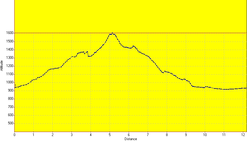
Distance: 12.2km Climb: 800m.
It was a cool day with showers, so we were eager to warm up. We left the car at 5 to 8, signed in at the walk register, then hit the Granite Tops Walking Track. By 8.35am we had completed the two steep pinches and had turned south east up the side of James Creek. The track is a little boring to this point, but an excellent up escalator. From this point there are great granite tors up the ridge to the left and by 8.55am we'd reached the dome of the former geodetic observatory, its old front door and window obviously bricked up. 15 minutes was enough to check out the view down into Orroral Valley, then shelter out of the wind by the dome whilst we had a quick bit of sustenance.
55 minutes saw us cover the 1.2km and 300m up to Orroral Hill. Although I had navigation bounds and bearings ready, it was visual navigation. I'd been warned that the trig point was a bit bouldery, so we headed between the high point and the obvious rabbit-ears rocks on the ridge just northwest of the high point. But, apart from the granite, the walking was easy in the open scrub. We had a bit of a peak over the western side first, but the cloud was down. A few patches of snow lay about. We then scrambled to where we reckoned the top was and a GPS check said we were within 6m. Looking up, we saw the high point marker above us. What navigation!
30 minutes was more than enough to poke around, have an early lunch and try to keep warm. Our trousers and shorts were wet (more from the wet scrub than the showers) and the wind was blowing a few snow flakes around.
At 10.35am we headed on 128°M towards Spot Height 1447. It required a little maneuvering to get off the south east edge of the hill, but there was plenty of vegetation between the granite boulders. Down, then up a little and we were at our next destination at 11.10am. Navigation was a little sloppy as, after snapping a few pics, a GPS check showed we were 14m out. Max found an excellent little cave.
10 minutes later we continued on down, again having to pass around large granite boulders. Our direction was 123°M, but we erred to the east a little to ensure we intersected the Nursery Swamp Walking Track. We hit it at 12.10pm.
We strolled down the track, arrived at the Nursery Swamp car park at 12.30pm and ambled up the grasslands, disturbing kangaroos, to the car at 1.10pm.
A nice little walk and I'm confident that I'd not lose too many participants the next time.
Time: 7.55am - 1.10pm with 55 minutes of stops.