26-29 January 2006 Chimneys Ridge - Mt Stony Photos
Map: Chimneys Ridge 8524-1N 1:25000
Getting There
This walk was organised and led by Rupert B as a CBC walk:
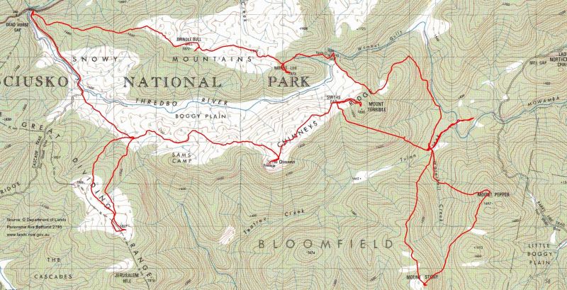
(' Thursday 26 - Sunday 29 January – Chimneys Ridge - Mt Stony; Kosciuszko NP – M/M/X. The upper Thredbo provides access to a number of points overlooking the middle Snowy valley and the Monaro beyond. There's Purgatory and Paradise Hills to the south, and to the east beyond The Chimneys the chance to explore to the high bulks of Mts Stony and Pepper and the streams behind them. Map: Thredbo 1:50000 Leader: Rupert B Transport: ~$50 Limit: 8 ').

3 of us walked.  We drove from Canberra via the obligatory stop at Jindabyne for morning coffee to just short of Dead Horse Gap at the Cascade Track Head.

Walk

Day 1: 26 Jan - Cascade Track Head to The Chimneys, with side trip to Spot Height 1827

It was a beautiful sunny day as we pulled on boots and gaiters and adjusted packs at the track head.  My pack weighed a respectable 20kgm, including 1.5l of water and 'personal comforts' (= 750ml of port to share!).  The March flies found us within seconds.  We were off and running - well, slowly working up to a reasonable pace - at 11.20am.  We followed the Cascade Trail for the first 2.1km as it winds along the Thredbo River into Boggy Plain, sharing it with mountain bike riders and family walking groups.  Excellent views back to the Rams Head Range.  Just after the ford of the river we left the trail, striking SE onto the lovely open and rolling Boggy Plain.  The treeless plain afforded us views to the NE to Brindle Bull Hill and Mt Leo (over which we were to return in 3 days time) and S of E to The Chimneys, our objective for the day.  We saw remnant wild flowers (Leek orchids, Trigger plants, Alpine bluebells, Orange everlasting daisies) and plenty of evidence of the local brumby population.  A further 2km saw us at our lunch spot at 1.10pm, lying in the shade of a Snow Gum on the edge of a field of orange daisies.  The warmth and the flies just took the edge off perfection.

At 1.30pm we left our packs and I loaded my little foldaway day pack with camera, water and snacks for our side trip towards Jerusalem Hill.  A push up through scrubby but open bush to the map marked heart of the Great Dividing Range for 2.7km saw us onto the more open ridge tops and finally at Spot Height 1827.  It was a further kilometre to the lower Jerusalem Hill, so we enjoyed the view from where we were.  The Chimneys loomed closer, larger and more rocky to the NE, views to the hazy SE and Jacobs River valley and back to the Rams Head Range.  I received a lesson in photo composition from the master and the difference between my snap and one a little more thoughtfully composed was remarkable.  We were back by 4.10pm, returning via the open ridge tops a little to the W and, a real thrill for me, encountering a group of five brumbies a couple of hundred metres away.  Their tracks, both today and on other days, often made for speedy travel as they sensibly contour around the hill tops on the ridges and head in the direction we needed.  The great piles of dung marking the tracks are soft and springy under foot, too!

My companions introduced me to one of the ubiquitous plants of the area, Mountain Pepper.  Sniffing a proffered leaf, I was advised to take a good bite of it - well named!  But at least they were honest  with me - it had been introduced to one of them years ago as 'mountain sugar'!!

We then headed another 4.1km east, across the N of the Sams Camp area to our camp site in the saddle below The Chimneys.  We reached the spot at 6.45pm.  The first of the nightly routines - set up tents, get water, cook and eat tea, a little socialising and enjoy a well earned sleep.  It blew a gale during the night, but it was a beautiful clear and starry night before it clouded over.

Distance: 14.4km  Climb: 550m.  Time: 11.20am - 6.45pm (call it 7.5 hours) with 1 hour of breaks.

01 Thredbo River about 1km from Cascade Track Head
02 Orange Everlasting Daisies
03 The Chimneys
Day 2: 27 Jan - The Chimneys via Smiths Gap to Tulon/Waterfall Creeks, with side trips to Mt Terrible and Mowamba River

We were up at a reasonable hour, breakfasted, broke camp and were ready for a quick climb up The Chimneys by 8am.  It was a short climb up to the rock cairn pinnacle, with the usual weather-beaten, broken pole in it and disks of tin from the old marker lying about.  What fabulous, 360°, uninterrupted views!  To the NW we spied the Main Range and ski lift infrastructure; S in the haze was Black Jack Mountain in the Byadbo Wilderness; E to Mt Stony, a walk objective; and, closer to hand, NE across the saddle from where we were camped to 'Little Chimneys'.

We were back down by 8.30am, picked up our packs, and headed along Chimneys Ridge in fairly open country often along brumby tracks.  9.50am saw us at Smiths Gap for morning tea.  After refreshments we headed to Mt Terrible, which wasn't so at all.  A gentle climb of 100m and 30 minutes saw us at the top.

Returning to our packs, we slung them on our backs and headed for the night's camp spot, near the junction of Tulon and Waterfall Creeks.  A drop of 420m over the 2.8km, taking us around 2 hours.  Quite hot, humid and sweaty when a gentle breeze could not be felt.  A lyre bird calling.  Ran out of battery in the GPS (1.5 days of track recording and only switched off at lunchtime was not bad for 2 rechargeable AAs), hence the straight line in the track across the S of Mt Terrible.  The bush was thick in places, with a wonderful tea-tree belt in a soak line as we neared the creeks.

Arriving at 12.40pm, we set up house (GR226540 MGA94), fetched water and had lunch.  My block of smoked cheese was fairly second hand in the heat.  I was then introduced to a most pleasant phase of bushwalking - the afternoon siesta!  And siesta we did after the strenuous drop in, enjoying nearly 2 hours in shaded tents zipped up away from the March flies.  A couple of rain showers.

3.30pm saw us up and away for an afternoon stroll down the creek flats, across the Mowamba River and heading towards Lady Northcotes Chair, a feature which was a possible objective for tomorrow's day walk.  We spotted an eagle being harassed by two crows.  However, it didn't look too impressive from our turnaround point at 4.40pm.  What did look impressive (ie. challenging) was glimpses of our exit route, planned for day 4, up the Mowamba River cut towards Wombat Gully - dense vegetation on steep hillsides heading up to open flats at the elbow into Wombat Gully.

We were back by 5.15pm and had a good wash in the creek.  Tea consisted of soup, beef teriyaki, jellied fruit, a nice cup of tea and a tot of port shared round.  Yummy biscuits were offered by my companions.

To bed by 7.45pm.  The building thunder storms rolled in and there was a magnificent light and sound show.  A fair bit of rain during the night, but bone dry in my new tent.

Distance: 10.1km  Climb: 150m.  Time: 7.50am - 5.15pm (call it 9.5 hours) with 3.5 hours of breaks.

04 Features off the end of Chimneys Ridge
05 Snow Gum
06 Returning from our afternoon stroll
Day 3: 28 Jan - Round trip to Mt Stony and Mt Pepper from Tulon/Waterfall Creeks, then move camp to near Wombat Gully

We were up and breakfasted, packed into a day pack and away by 7.40am, heading south up the spur paralleling Wombat Creek on the way to Mt Stony.  Rupert and Lois are great naturalists, every now and again pointing out plants and various creatures.  Lois spotted the first native snail.  They exchanged many Latin names, but it all sounded like Greek to me.  However, I did learn of the territorial round of the lyre bird and the pecking order in a Kookaburra family.

By 10.15am we'd climbed the 3.7km and 430m up to Mt Stony.  Great views again, which we admired for 30 minutes.

We headed steeply down to the NE to the cleared saddle from which Wombat Creek flowed.  I was happy to replenish water, as I'd not carried enough and had been forced to drink, via a plastic bag, from the small rock pools filled overnight on Mt Stony.  We continued in a generally north-easterly direction to Mt Pepper, contouring around the features on the way.  I had been fooled by my second edition Chimneys Ridge 1:25000 map as I'd prepared - the contour interval was 20m (rather than the normal 10m), so on the map the going looked a little more gentle than it actually was!  We reached Mt Pepper at 12.20pm, lunched and enjoyed the views across to the Monaro.

We started out again at 1.10pm, dropping the 270m down to Waterfall Creek.  Thunderstorms were building in the E again.  Passed the little dragon (pictured, right).  Pleasant to walk the last 800m down the gurgling creek - click here to listen to it.  We were back at the tents by 2.15pm.

A short siesta followed but, having made the decision to begin our exit, we packed and, at 4pm, headed north towards the Mowamba River.  It was steamy humid.  The flat leg to the river was fine, but we soon had to turn NW and up the steep, densely vegetated cut.  We managed 1.4km and 255m up in 1.5 hours, stopping at 6pm at the most unlikely looking tent sites, sloped on the side of the gully, as the rain started.  Our fearless leader called it a "sustained push" but, when challenged, admitted it was a "sustained grunt".  I'd learned my lesson yesterday and carted up 2.5l of water; the others had to return 200m to a soak to replenish for the night.  Thankfully, the rain eased.

Tea for me was a huge affair.  Although it may not sound appetizing, I'm rather partial to TVP (textured vegetable protein), as long as it's laced with plenty of Thai sweet chili sauce. With some dehydrated peas and corn and 2 minute noodles, it makes an extremely quickly prepared and tasty meal.  But there was enough to feed a small army, so it was shared.  Jellied fruit again, coffee, fearless leader's chocy biscuits and licorice allsorts and the last of the port.  GR221562 (MGA94) suddenly seemed a little brighter.

In bed by 7.40pm.  Rain during the night, but local and constant, not thunderstorms.  I'm not a good bush walker, as I hate H (heights), W (water), B (blood) and WD (wild dogs)!  I spent a restless hour or so during the night as a pack of 3 or 4 howled in the distance.  In the morning I found that my companions had slept through the noise!!

Distance: 11.7km  Climb: 900m.  Time: 7.40am - 6pm (call it 10.25 hours) with 3.25 hours of breaks.

07 Native snail
08 Panorama view from Mt Stony W to E
09 Dragon on flanks of Mt Pepper
Day 4: Wombat Gully via Teddys Hut, Mt Leo, Brindle Bull Hill to Cascade Track Head

Up at 6am to a clear sky, a leisurely breakfast in bed (mainly to escape the flies and mosquitoes) and ready by 7.25am.  We set off at 7.40am; it was already hot.  By 8am we had contoured round and up to the open alpine area NE of Mt Terrible.  Rupert had spied a large field of everlasting daisies and we spent some time taking photographs.  It was pleasant in the shade.

At 8.20am we were away again, this time finding the easiest route over open ground and diagonally up to ridge tops on the way to Teddys Hut.  Nearing it we saw two other walkers, Rupert and one of the other party finally recognising each other as CBC members by their similar orange shirts.  At Teddys Hut by 9.20am and we spent 25 minutes having a look around and taking photographs.

9.45am saw us heading west to the source of the Thredbo River, then on to N of Mt Leo.  We spotted a herd of brumbies in the distance.  Dropping packs, we headed up Mt Leo, reaching the 1875m summit at 10.40am.  An excellent vista S to our route in across Boggy Plain, Chimneys Ridge and Mt Terrible.

We headed back to our packs and continued W and N to near Brindle Bull Hill.  We found a perfect spot in the shade for lunch at 12.10pm and, after eating, we two guys covered ourselves in coats and netting for protection from the March flies and ... had a short siesta!  Lois borrowed my camera and took some beautiful shots of Snow Gums.

An hour later we headed up a knoll near Brindle Bull Hill for more views both S and N.  Excellent views up to Paddy Rushs Bogong and Drift Hill, the rolling, open uplands inviting a walk back in this area.

We were back to our packs and on the final leg at 1.30pm, covering the 4.5km back to the car in 1.5 hours.  Again, brumby tracks helped us move quickly down the spur.  Packs dropped at 3.10pm.

A welcome wash up in the Thredbo River below the bridge at the track head.

Distance: 11.9km  Climb: 350m.  Time: 7.40am - 3.10pm (call it 7.5 hours) with 2.5 hours of breaks.

10 Alpine views over a field of everlasting daisies
11 Brumbys near the source of the Thredbo River
12 Thredbo River valley (Boggy Plain) from Mt Leo
An excellent walk in new country for me.  Great company and a leader whose navigation and bushcraft continue to inspire me.  Thank you, Rupert B and Lois P.

Home