This walk was organised and led by Chris L as a CBC walk:
(22-24 April – Kelly & Kelly Spur from Boboyan – M/R Day 1: Walk in to Rotten Swamp. Day 2: Round trip to Kelly, Kelley Spur and return to Rotten swamp via Licking hole Creek. Day 3: Return via one of many possibilities. This will be classic Namadgi bushwalking, and the pace need only be fairly casual. Map: Rendezvous Creek 1:25000 Leader: Chris L ~$15.). Forecast fine, frosty, 1-17°C in Canberra. Great conditions to try my new 'Reactor' sleeping bag liner which should add a couple of degrees to my barely 3 season sleeping bag. 6 gentlemen met at Tharwa and we drove to the Yankee Hat car park. It was great to catch up with guys I'd walked with before. |
Day 1:
We were kitted up and ready to walk at 9.20am. The view under the bright blue sky across the dry grasslands was magnificent - Mt Kelly peeking around Yankee Hat north, Mt Burbidge with its rocky crown, Mt Namadgi with patches of snow on its southern flanks - all rearing above the various arms of Middle Creek. Most of us suspected we were in for lessons as our leader casually slung his 11kgm pack to his back; I thought I'd done well at 19kgm.
The usual route along the Yankee Hat trail towards a dry Bogong Swamp and over the bridge, then cutting across the grasslands to the mouth of Middle Creek. Up to the end of the open area, across the south arm of Middle Creek and to the fence crossing Middle Creek for a stop at 10.40am (4.5km and 1hr20min). The next leg took us up Middle Creek to about 500m west of the top junction, where we stopped for lunch at 1pm for 30 minutes. A few patches of snow about (8.3km and 3hr40min). We had just crossed to the northern side of the arm of Middle Creek which leads to Rotten Swamp and our next leg for the day had us sidling between the creek and the SE spur of Mt Namadgi. Wonderful views left to Mt Burbidge (pic 1) and right to Mt Namadgi. We reached the edge of Rotten Swamp at 3.30pm (10.6km and 6hr20min). A whole lot better trip than my last time down this route!
We broke onto Rotten Swamp with great views ahead to Mt Kelly (pic 2). The patches of snow on Mt Namadgi were a little more obvious. We headed across the pretty dry swamp to the western edge, then down Licking Hole Creek a little and set up camp just in the tree line at 3.50pm (11.2km and 6hr35min). Soft grass to sleep on and handy rock platforms for kitchen and communal areas. Water just a few tens of metres away from the creek. The sunset over the swamp and surrounding hills was excellent (pic 3). I dressed for dinner - long-johns under my shorts, several more layers on top and a beanie. The usual - TVP, Thai sweet chilli sauce, dehydrated peas and corn with 2 minute noodles, jellied fruit, a coffee bag and a little port to share to help the minutes tick over till bed time around 7.30pm. The frost had already settled on the tents. It was lovely to leave the door open and gaze out onto the black mounds of hills and the sky pierced by blazing bright stars. Felt a bit like a Jerra resident though, as we appeared to be directly under the low flight path for Canberra landings and the high Sydney-Melbourne route.
Distance: 11.2km Climb: 450m. Time: 9.20am - 3.50pm (call it 6.5 hours).
Day 2:
Up at 7am for ablutions, then back to bed. The frost was cool, but the sun was quickly streaming across Rotten Swamp to our westerly site. Another picture perfect, blue sky day. Muesli, Vita-wheat and vegemite, and a cup of steaming hot coffee for breaky.
We were away with day packs by 8.20am, heading SW along the edge of Rotten Swamp until a better approach to Mt Kelly opened up. Then SW and up, reaching the top of Mt Kelly at 10am (1.7km and 1hr40min). Astounding views opened up as we came out of the tree line onto the granite slabs! Starting from the N, E of the Cotter River, we saw Coronet Peak, with Split Rock further away and the Tidbinbilla sky-line in the distance. Swinging clockwise, the Namadgi ridge over Licking Hole Creek, leading to the Namadgi high point with snow patches still on the southern flanks. Rotten Swamp lay below, then the majestic granite bulk of Mt Burbidge with the arms of Middle Creek at each side. Over Bogong Gap we spied the Gudgenby grasslands, the edge of the pine trees clearly marking where our cars were parked. Yankee Hat N was easy to identify then, closer, Spot Height 1733 and the ridge down to Mt Gudgenby (pic 4). South lay Yaouk Peak, then the Mt Scabby - Mt Kelly ridge returned our gaze closer. Back to the middle distance we saw Mt Morgan, Mt Murray and Murrays Gap (where I was the previous fortnight), Bimberi Peak and the Brindabellas marching north. Starting near at hand and directly west of us was our objective for the day - Mt Kelly Spur undulating to the north. Absolutely fabulous! We signed the log book and continued to admire the views for 25 minutes.
We headed W and down at 10.25am, to an open saddle, then up the other side to start our Mt Kelly Spur wander. A mere 0.95km, but 1hr10min for this leg (making 2.6km 2hr50min for the day so far). A 15 minute pause to admire the view. The W side of Mt Kelly is rugged granite and Mt Namagdi was over Kelly's northern ridge. To the W the upper Cotter River, with Rolleys Flats, Upper Cotter Flats and Cotter Flats was in view.
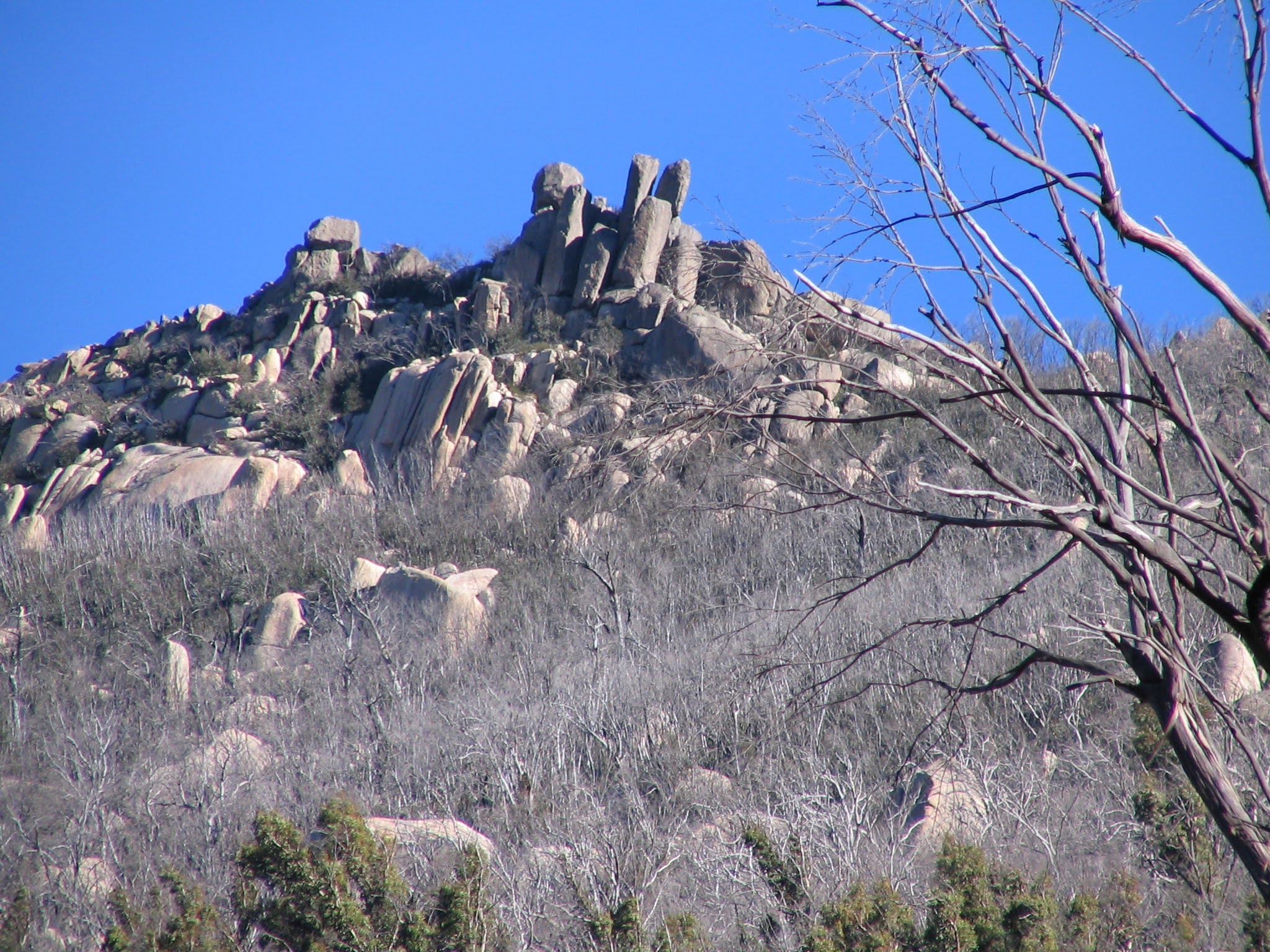
At 11.30am we headed north. Fairly easy walking along the subalpine ridge. We reached Spot Height 1721 at 12.15pm. Passed an excellent rock formation with a name simultaneously coming to mind for my walking companion at the time and myself - Boar rock (pic 5). Excellent views back and down to Rotten Swamp and its surrounding sentinels (pic 6). After a 10 minute break we continued north to what could be a pleasant, saddle-enclosed tarn - if it had any water in it. Great views both E to the Namadgi ridge and W to Gurrangorambla Range and Brindabellas. But 12.45pm was declared lunch (4.7km and 4hr25min).
35 minutes later we shouldered our gear and continued a further kilometre up and along the spur, through Spot Height 1669 to an obvious knoll. We reached it at 2pm. This was to be the extent of our Kelly Spur wander (5.9km and 5hr40min). Great views to Coronet Peak and Cotter Flats. With time on our side we lay about like lizards on the warm rocks in the sun. I'm sure I had a ziz during our 45 minute break.
Away at 2.45pm, all that was left was to retrace our steps to SH 1669, then SE down the obvious route to SH 1415 on Licking Hole Creek. The sun was beginning to slant as we walked up the (dry) swampy area to our camp site. Home by 4.15pm (8.9km and 7hr50min).
A cup of soup went down well, then the usual drill - change for dinner, cook, eat, drink and yarn. Another late night of around 7.30pm. Frosty. Although my light bag and new liner coped well, I'm not so sure it would in the snow.
Distance: 8.9km Climb: 600m. Time: 8.20am - 4.15pm (call it 8 hours at a casual pace with many breaks).
Day 3:
Another crisp morning, with frost showering inside my tent as I opened the inner door. Initially Rotten Swamp was frostily clear, but it was wonderful to watch the fog roll in through the mouth of Middle Creek to fill the flat (pic 7). Soon the blue sky was gone and, in the other direction, Mt Namadgi could be seen under the cloud. But it burned off after a couple of hours.
Chris had plenty of options available for our exit and it was decided to head for Bogong Gap and the other arm of Middle Creek. An unhurried breakfast and pack up and we were away by 8.45am.
We crossed Rotten Swamp for the last time via the little island of trees, hit the southern end of the swamp, then climbed to Bogong Gap (1.5km and 40min).
Down the creek on the north bank to the 1490m contour where we crossed to the other side. Wonderful views up to the granite on Mt Burbidge. Down, down and more down, following a little closer to the creek than my last time down this route exiting from Mt Burbidge. A pause at 10.15am for morning tea near the 'avoid' area penciled in on Chris's map - the impenetrable tea tree patch in Middle Creek. We headed up and a little further away from the creek at the steep cut between the 1400 and 1100m contours. The Gudgenby grasslands looked tantalisingly close, but there was still a way to go. Great views to the back of the Yankee Hats. We reached the open area 400m S of the bottom junction of Middle Creek arms for lunch at 12.30pm. From Bogong Gap to lunch was 5.6km, taking 2hr55min (for the day so far, 7.1km and 3hr45min).
Another lazy break, with a stove or two appearing for soup and a cuppa.
Away at 1pm, the 3.5km out the mouth of Middle Creek and across the grasslands taking 50min. An arty-farty shot of a tree (pic 8) and a roo playing hide-and-seek (pic 9). Back to the cars at 1.50pm (10.7km and 5hr6min).
Distance: 10.8km Climb: 200m. Time: 8.45am - 1.50pm (call it 5 hours).
Max spotted a roo caught in a fence as we drove out and the lads bravely rescued it. To Tharwa shop for an icecream, then home to civilisation.
This was indeed magnificent 'classic Namadgi bushwalking' and at a 'fairly casual pace'! Thanks so much, Chris L, for planning it, leading us and ordering the great weather. Thanks also to Bob E, Quentin M, Max S and Ralph Y for their company. The primary walk lesson was weight and warmth.
Total distance: 30.9km Climb: 1250m. Time: 3 days.