| Getting There
This walk was organised and led by Rupert B as a CBC walk: (9–11 December – Mts Kelly and Burbidge, Namadgi NP – M/M Got a spare Monday? From a base near Rotten Swamp (it’s neither actually) climb a couple of Namadgi’s classic peaks, including ‘king’ Kelly. We’ll get there along a tributary of Middle Creek, and return along part of the Yankee Hat ridge. Map: Rendezvous Creek 1:25,000. Leader: Rupert B Transport: $8. Limit 6.). 5 of us drove to the Yankee Hat car park. I was pleased that a ½ inch (no exaggeration) plank (a small exaggeration) finally popped out of my knee a couple of days before the walk, so I was ready, willing and able. Weather Forecast for Canberra Saturday: Fine, mostly sunny 14 - 34 Sunday: Fine, mostly sunny 15 - 36 Monday: Shower/thunderstorm 18 - 35. |
This was an excellently paced walk in the heat and, again, plenty of lessons. The main one was pack weight, with much discussion as 4 of the party are off to Tasmania in February with Rupert. On this occasion, one braved the creepy crawlies by sleeping under a fly and two ate cold, so their pack weights were minimised. On the other hand I lugged 22kgm (good practise!) - this was all-up weight including 3 litres of water, 1 litre of a quite nice Cabernet Merlot, 1.7kgm of new camera, .... Something will have to go to make room for 11 days food in Tasmania!
Day 1
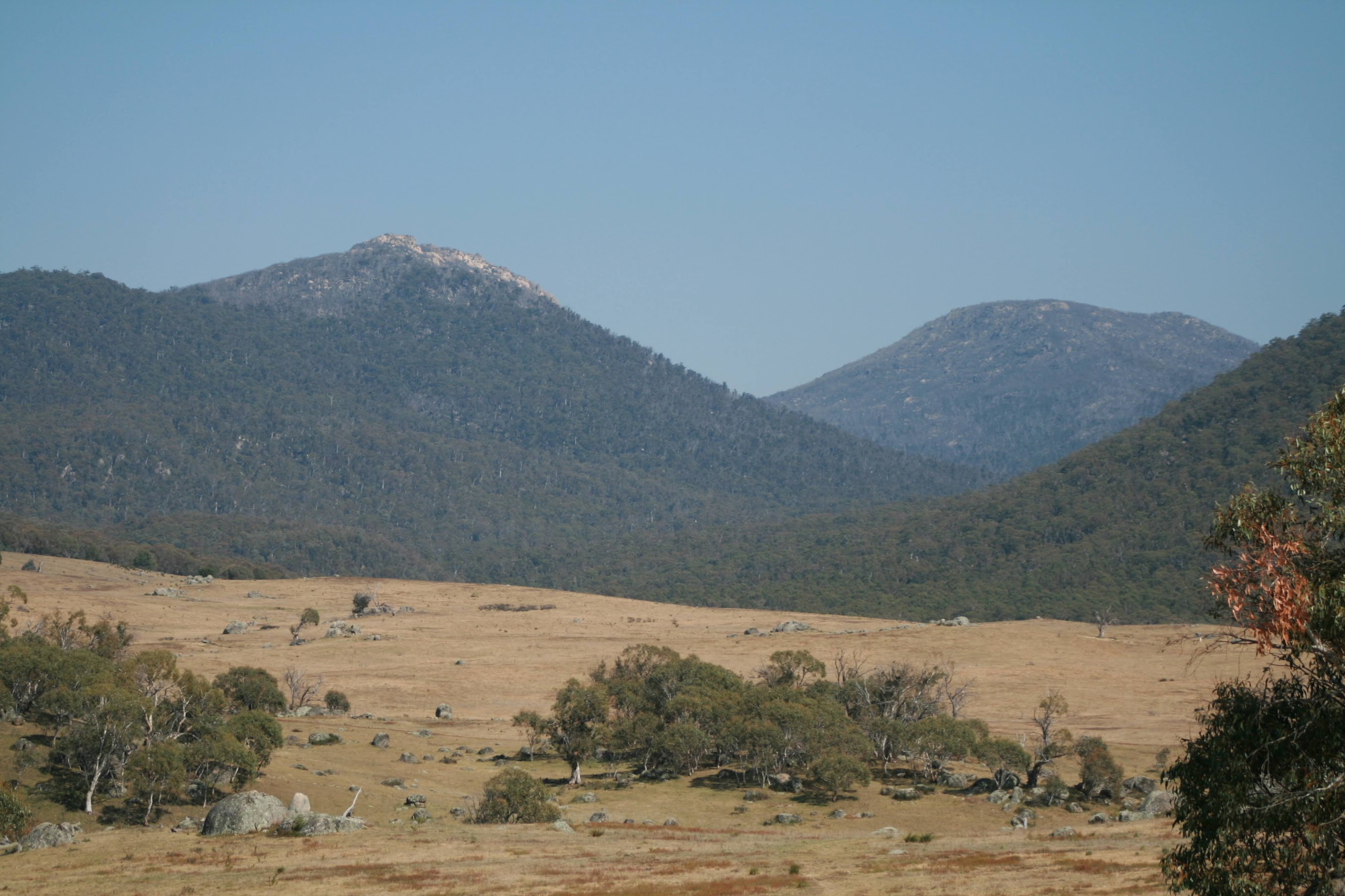
We hit the track at about 9.15am, the peaks rearing as usual up at the head of Middle Creek (see pic 1). Through the 'roos, across the bridge over a fetid Bogong Creek and across the grasslands. It was obviously going to be hot. We stopped at 10.30am after crossing the south arm of Middle Creek for morning tea and for some to follow it down towards the main north arm until water could be obtained (4.2km to here). I took the opportunity to drink up too.
We next headed up the Burbidge spur. A wisely chosen even pace got us to lunch on the second terrace of the spur at 12.15pm (this leg 1.8km).
The afternoon leg took us up the next climb through the 1400m contour to just below 1500m, then a sidle contour along the SW flank of Mt Burbidge above the arm of Middle Creek which comes from Bogong Gap. We eventually sited the creek flats, but held our height and arrived at our Bogong Gap camp site at 3.50pm (this leg 3.4km). This was one of many wise plans made by our leader, saving us many metres of climb the next day, compared with camping in Rotten Swamp. The only gamble was water, which was found 300m SE down the drainage line.
Plenty of time to set up camp, rest away from the afternoon heat, fetch water, enjoy tea (my ubiquitous TVP and 2 minute noodles), then stroll a few hundred metres to an open terrace NE to give us views of the surrounding area. A few wild flowers (see pic 2). Time to practise camera technique, although the sunset did not give us colours we'd hoped for (see pic 3).
A mild night, not a breath of breeze, starry with the moon out later. Lovely not to be cold. A couple of Phil Pringle's podcasts and a little rock 'n' roll lulled me to sleep.
Day 2
The day's plan was to pop up Mt Kelly, then Mt Burbidge. Mt Namadgi was not an option in the heat. Away at 8am and up 1.5km and 260m climb to the cairn marking 'king' Kelly. We reached the summit at 9.15am. My 4th ascent for the year, but the views remain staggering! A little smoke haze in the distance, but fabulous views to Mt Namadgi, Rotten Swamp, Mt Burbidge, Bogong Gap and down Middle Creek to the grasslands, SH1733, Sentry Box Mountain and SB Rock, Mt Scabby, Mt Morgan, Mt Murray, Bimberi Peak and Coronet Peak - to name a few.
We headed down at 9.40am. Rupert and the rest of the party were willing to take up my suggestion to head SE for SH1733. In my mind, Mts Kelly, Burbidge, Namadgi and SH1733 are the sentinels of the Bogong Gap/Rotten Swamp area and I'd been hankering to get to this open granite area for some time. We covered 1.5km down Mt Kelly then up towards SH1733, stopping on a granite knoll a couple of hundred metres short of the SH. The wind was quite strong and the views quite magnificent (see pics 4 and 5) from the open granite slabs.
Back down at the camp site we gathered lunch together and headed 0.75km and 170m up to Mt Burbidge, taking 40mins. Enormous views again, with my interest to the Mavis Ridge (a day trip over it to Mt Namadgi in autumn is a dream of mine). Then into a most wonderful cavern/rock shelter for lunch and a laze about. Flow-through ventilation and the shade were perfect.
Back to camp by 1.30pm and, with a local thermometer showing 38°C in the shade, the wisest thing was to lie low. I'd sited my tent in the blazing sum, so took empty pack, fly net and MP3 player under a shady tree for a few hours. March flies and bush blowflies a pest.
A water trip, pre-dinner drinks and conversation, tea (classy roast lamb and mashed potatoes - Back Country freeze dried style), then a stroll to last evening's viewing terrace. More smoke haze this evening (you could smell it) and, combined with the sultry thunderclouds and technical direction from Rupert, a reasonable pic (see pic 6). Another starry night after the clouds cleared.
Day 3
I was particularly looking forward to the homeward leg along the ridge towards Yankee Hat, as I'd (foolishly) planned to get here on a day walk from the Hats on 29 August. An excellently executed route as we climbed a few gentle tens of metres, then contoured round SH1733 to reach the ridge near the top of Bogong Creek. Then a lovely (hot) stroll along the open ridge, with excellent views to the Scabby Range portion running from SH1733 down to Mt Gudgenby. Views back along this leg, too (see pic 7).
But it was soon time to begin the descent and we plunged down to the SE. Morning tea at 10.15am at around 1400m, 3.2km and 2hr 20mins from our camp site.
The contour lines gradually widened and this next leg took us across the back of the Yankee Hats, out into the open mouth of Middle Creek and down to the creek for a wash and lunch. The break and foot wash for some were most appreciated.
The thundery cloud cover must have lowered the temperature a little as we plugged back across the grasslands, "the longest mile to be walked in Namadgi!". Back to the car at 1.40pm.
A drink and icecream at the Tharwa store.
My main issue with the new camera seems to be correct focus using the zoom lens (as well as taking all the landscape shots on portrait setting because I can't see the mode dial without my glasses). But the quality at 10.1Mpixels is superior, even when reduced to 800*600 and 80% quality for this blog.
This was a great walk, well paced for the challenge of the heat. Excellent to revisit these high hills and really excellent to experience a bit more of SH1733 and the Yankee Hat ridge. I'm nearly starting to believe the fable that multi-day walking (rather than day walking) is the only 'real' walking! A master navigator and great company. Thanks Rupert and Jenny, Kim and Margaret.
Distance: 26.5km Climb: 1200m. Time: 3 days.