This walk was organised and led by me as an irregular CBC Tuesday walk:
(Tuesday 15 January — 14r feature and Pierce Hill — L/E-M,X. From a convenient fire trail in Pierces Creek forest, walk via the Tidbinbilla Range Road through Black Spring Mountain down to explore the 14r feature on a feeder to Pierces Creek. Back up to the road and, just to make a different way home, head to Pierce Hill. Exit the Tidbinbilla Range via the fire trail down the spur to the SE of Oakey Creek. All on fire trail except for 1.5km and 200m down to the falls. Around 15km and 700m total climb. Maps: Cotter Dam and Tidbinbilla 1:25000. Limit of 8. Leader: John Evans – jevans@pcug.org.au, (h) 6288 7235; contact me by 6pm the previous Sunday to discuss options. Transport: ~$10. Further details at http://jevans.pcug.org.au).
This walk was so dull that no one wanted to come with me, so I did it alone. Drove out through Cotter and up along Paddys River Road. East of Sugarloaf Hill, turn right along Laurel Camp Road for 2.9km, then right into the straight ~E-W fire trail for 800m to the 4-way intersection at GR73878446 (GDA94). All good dirt.
Route Card
|
Route Card - 14r feature and Pierce Hill |
||||
| Leg | Waypoints | Dist (km) | Going | Est time (hh:mm) |
| 1 | 1-2 | 0.7 | 700m S from proposed start point to join Tidbinbilla Range Road | 0:15 |
| 2 | 2-3 | 0.9 | 900m along TRR, climbing around 100m to the ridge top | 0:30 |
| 3 | 3-4 | 2.4 | 2.4km along TRR, through Black Spring Mountain and past SH1136 to the top of a spur falling away to the W | 1:15 |
| 4 | 4-5-6 | 0.75 | 750m across the ground and 180m drop down the spur on the S side of the drainage line to the bottom of the 14r feature | 0:30 |
| 5 | 6-7-8 | 0.1 | Around 55°M for 100m across the bottom of the feature | 0:15 |
| Morning tea | 0:15 | |||
| 6 | 8-9 | 0.7 | 700m across the ground and around 150m climb back up to Tidbinbilla Range Road | 0:30 |
| 7 | 9-10 | 2.2 | Follow TRR for 2.2km to Pierce Trig | 1:00 |
| Lunch | 0:45 | |||
| 8 | 10-11 | 0.45 | 450m S there is a fire trail which leaves TTR down a spur to the ENE | 0:15 |
| 9 | 11-12 | 2.3 | 2.3km down the fire trail, dropping 400m to the edge of Pierces Creek Pine Forest area | 1:00 |
| 10 | 12-13-1 | 4.5 | Follow fire trails 4.5km to the N, then W, back to the car | 2:00 |
| 15.0 | 8:30 | |||
Civil twilight: 0535 - 2050
Walk ![]()
Tromping the fire trails by 6.25am with a forecast 33°C for Canberra. Birds in the early morning, including king parrots, currawongs, a hawk and lyrebird within 15 minutes. The Tinbinbilla Range Road (renamed Camel Back Fire Trail when it enters the Tidbinbilla Nature Reserve at GR731838 (GDA94)) climbs steadily through Black Spring Mountain and SH1136. I reached the drop off point to the 14r feature at 7.25am. Legs 1,2,3 above, 3.8km climbing 350m in 1hr.
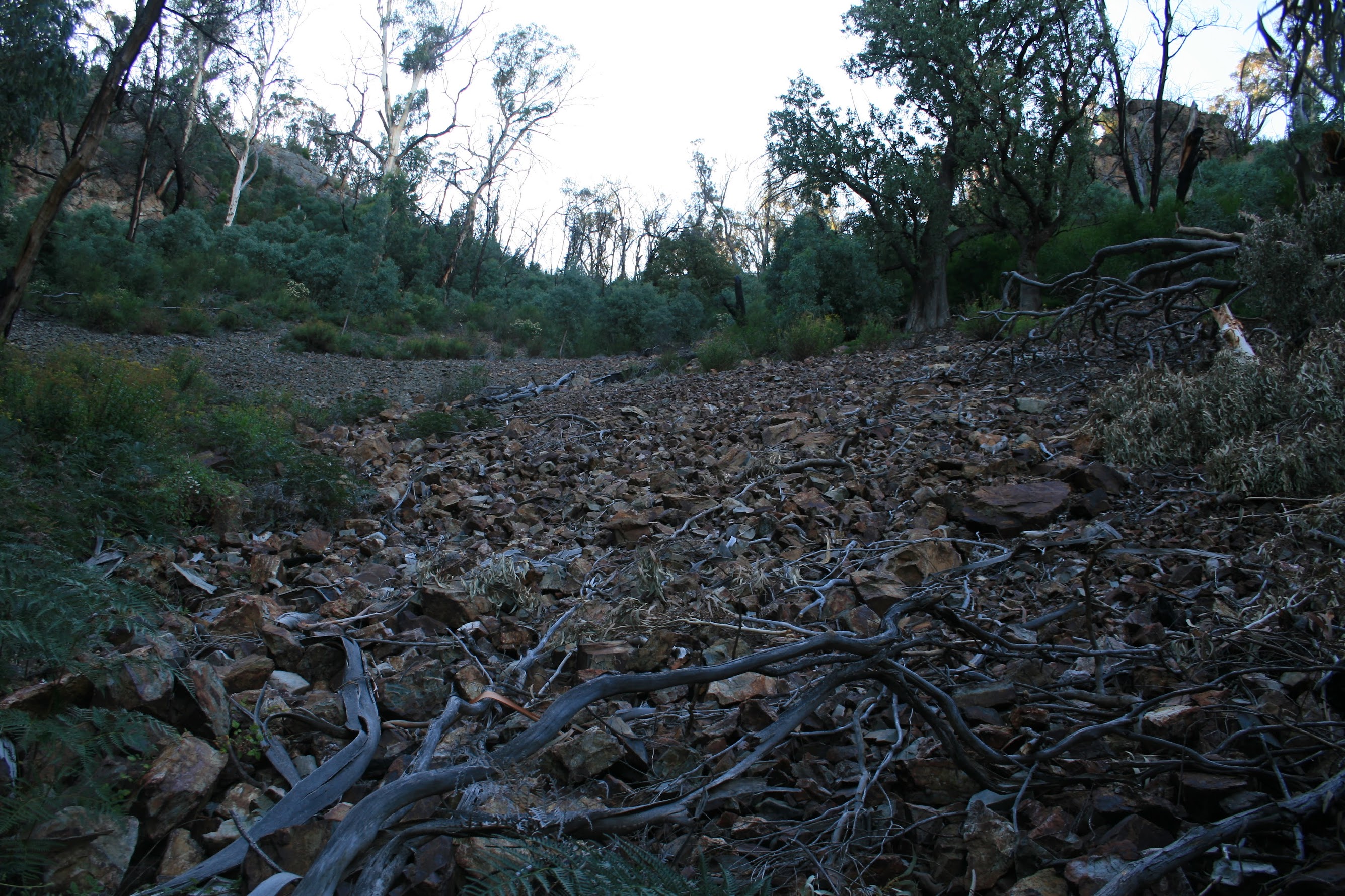
Next down to the 14r feature. Alas, like Elsies Falls just NE of Camels Hump, not there! There's a great patch of unstable scree (see pic 1) which is very difficult to walk up and a reasonable sized bluff towering above, but no vertical drop. On return and checking my GPS track, I went exactly up through the bottom of the 14r feature. The spur down and up was relatively open forest with shale and scree underfoot. Something like legs 4,5,6 above, 1.8km dropping and climbing 200m in 1hr 15mins. A bit disappointing.
With the main object of the day out of the way, I thought I'd press on to Camels Hump rather than just Pierce Hill, to get an idea of timing for our Tidbinbilla Range traverse on 29 Mar 08. So the next leg was along TRR for 2.2km climbing 250m in 35mins to Pierce Hill and Trig (leg 7, above). Great views, as usual, down into the Oakey Creek gully and across to Spur 3. The Tidbinbilla Tracking Station dish was visible and, in the hazey distance, southern Canberra suburbs. A 15min break for morning tea.
Next a jaunt further S along TRR and up the N route to the top of Camels Hump. This leg 1.7km climbing 140m in 35mins. Huge views to the SSW to Johns Peak, Tidbinbilla Peak, Tidbinbilla Mountain and The Pimple which, a few metres down along the S route from the top, are unhindered by timber (see pic 2). An opportunity to think about a Hardy Range to Camels Hump wander suggested by Mike B.
With the temperature rising and the juke box (if I had one) blowing a fuse, it was time to head for home. 10mins to cover the 0.25km and 90m down to the Camel Back Fire Trail.
Then on fire trail back around to the E of Camels Hump to the top of Spur 3 and down the very steep fire trail to the regenerating forest area. Views of Pierce Hill from an angle I'd never seen before. A Grass Tree beside the fire trail (see pic 3). This leg 3.9km in 1hr 5mins dropping 420m, including a 15min break for morning tea number 2 and to examine a fire trail blister (now I know why no one came!).
5km in 1hr back to the car via a slightly different route than planned. Oakey Creek was running in a culvert under the road.
Boring fire trail, no falls, but it had to be done. As for timings for future walks, start via Tidbinbilla Range Road, over Pierce Hill and Camels Hump is 8km in 2.5hr (incl 10min break).
Distance: 18.2km Climb: 1000m. Time: 6.25am - 12.20pm (call it 6hrs), with 30mins of stops.
Grading: L/E-M,X; H(12)
KMZ file for Google Earth/Maps: 14r feature, Pierce Hill and Camels Hump