This walk was organised, led and partied by me as a private, spur-of-the-moment walk:
Saturday 19 April - Cotter Caves and Mines; Sugarloaf Hill - S/M,X. Visit these Sites of Significance in the ACT and have a poke around.
The Cotter Caves area is Site of Significance in the ACT number PT1 and Sugarloaf Hill is number LC7.
Walk
Walk 1 - Cotter Caves area
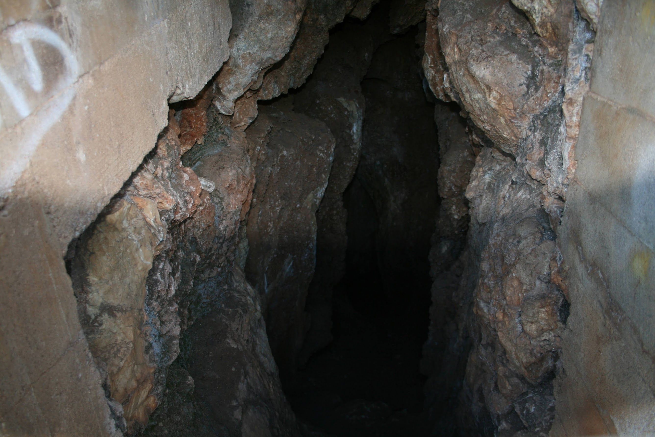
From the car park at Cotter bend over the foot bridge over the Cotter River. The walking track this way to Cotter Caves has been barricaded off, as there has been a small rock fall over the path. Like many others before and after me, just press through. The concreted and then well worn foot track heads from the riverside through regrowth, then onto a fire trail. The caves soon come into view, with a viewing platform since the last time I was here on 16 Feb 05. Had a peek at the signage, up the (new since last time) steps to the platform and a look into the first cave. The grills over the entrances to the second and third caves are obvious, a few tens of metres up and round the hill. Nice view from the platform back to the Cotter Reserve and the northern end of the Bullen Range. Visited the second (see pic 1) and third cave entrances, then up the hill to the fire trail running along the ridge. I had GPS waypoints for the two abandoned mines marked on the 1st edition map. The first led me to the adit (see pic 2), well filled in but with the steel cart tracks still lying on the ground. I followed the drainage line up, looking for the second location, but I couldn't find anything else. The sketch map in the SoS shows a pit (which I visited later) and an adit - this is perhaps a truer representation of the features. At the top I wandered along an overgrown fire trail, first to the W and N some metres, then about turned and came back E and N. This runs along the ridge to the E of the drainage line. At a suitable point I turned off to the left, down and up to the obvious pit area. It appears three separate leads have been filled in. The area above the bare rock was green (a soak?) and inviting, so I wandered up to an area with several grass trees. Back down and up to the fire trail and so over the top of the viewing platform and first cave. On the ridge you could see the rillenkarren (limestone weathering) of the rocks. Back to the fire trail and so down to near the steps going to the cave. Returned. A good map of the walking tracks around the Cotter Reserve on the side of the toilet block, including 2km of wheelchair track. I'll take my wife on a nice day.
Here's some interesting information copied from http://www.markbutz.com/Butz%201987%20Karst%20and%20caves%20in%20the%20Canberra%20area.pdf:
Paddys River Caves
The Paddys River (or Cotter) Caves escaped the fate of the Limestone Plains complex by their relative isolation. They lie about twenty kilometres west of Canberra in a steep outcrop up to fifty metres above the south bank of the Paddys River. The limestone here is about one hundred metres long and forty metres thick, tilted to near vertical, and metamorphosed to marble by an intrusion of adamellite (Owen and Wyborn 1979). The deposit has not been economically exploited despite favourable reporting of its suitability as a ‘handsome ornamental stone’ after successful polishing (Mahony and Taylor 1913). Because of the metamorphic effects, fossils in the outcrop tend to be limited to crinoid stems (Rosengren 1985). Three caves have been described - the Cotter, Powder Store and Blasted Caves. The lengths of these are sixty-five, fourteen and twenty metres respectively. All were probably interconnected and formed by the one stream (Nicoll and Brush 1975a). The values of the karst area and its environs are gaining wide recognition: The National Capital Development Commission (NCDC) have registered the caves as a geological monument (NCDC 1984) and a larger area as a Site of Significance (Rosengren 1985), and they are also listed on the Register of the National Estate (AHC data file) and on the Register of Classified Places (National Estate (AHC data file) and on the Register of Classified Places (National Trust 1982). To give force to such listings a great deal more attention needs to be paid to management for long-term conservation. Past management has been marred by lack of awareness of the area’s values, inappropriate design and construction, fragmentation of responsibility and a lack of consultation with community interests. Despite some heavy-handed gating, access to the caves has rarely been controlled. From the combined effect of this unsupervised access and unsympathetic management nearly all accessible speleothems have been removed or destroyed, floor deposits have been altered, roosting bats caused to vacate and the caves littered and defaced. This legacy has led to a view of the lost caves as ‘no longer sensitive’ (Rosengren 1985) or as a lost cause, leaving them open to proposals for development as a recreation asset at the expense of other values. Rather than accept this view of expendability, the Service would prefer to recognise that the caves are a non-renewable resource and have intrinsic value as the only accessible caves in the ACT to survive Canberra’s construction. Specimens of cave-dwelling spiders have been collected from the Cotter Cave, including Stiphidon facetum (AP Spate, pers. comm.) and Epimecinus sp.nov. (Gray 1973). While these species also utilise surface habitats, all cave invertebrates are significant elements of the biota (Poulson and White 1969) and their continued survival may require careful management (Reider 1977). The Cotter Cave is still sometimes occupied by bent-winged bats (Miniopterus schreibersi) and this cave (together with a nearby water supply tunnel at Cotter Dam) may be an important staging point between maternity caves at Wee Jasper and coastal roosting sites (AP Spate, pers. comm.). In 1958, the first recovery in Australia of a banded bat occurred at the Cotter tunnel, fifteen days after the bat was banded at Wee Jasper, thirty kilometres to the north-west. This was the start of a new understanding of seasonal bat migrations, biology and life cycles (Purchase 1962). There has also been speculation that the caves may be an overwintering site for the bats (C.R. Tidemann, pers. comm.). This implies a need to control public access (Voute and Lina 1986) although the existing gating would require extensive modification to facilitate bat movement (Tuttle 1977). Other bat species that inhabit caves have not been examined for stratified bone deposits or evidence of prehistoric occupation (JH Hope, pers. comm.) although the Cotter Cave has considerable potential to contain occupation evidence due to ample headroom, daylight entry, a view over the river, and close proximity to recorded Aboriginal campsites. Such deposits and traces in caves have great scientific importance (Jennings 1979) and a trial stratigraphic excavation should be made in these caves before any further developments or modifications are effected. The caves have a physical and historical association with an adjacent mineral deposit at the contact of the limestone and adamellite. This is a magnetite skarn containing small quantities of lead, silver, zinc, gold (Smith 1963) and the Congwarra Copper Lode was first prospected in 1895 (Smith 1963) and prospecting continued until 1908, and again in 1946 (Owen and Wyborn 1979). At an early stage there was an adit up to thirty-six into the copper lode (Jaquet 1901) and at least three other adits and seven pits were shown on a surveyor’s plan of 1917 (Barz and Winston-Gregson 1982). Mine remains still visible include a pit and a partly closed adit. The particular usefulness of Powder Store Cave to the miners is self-evident. This is the only significant mining area known in the ACT and is thus of considerable historic importance in the Territory (Barz and Winston-Gregson 1982). The combination of karst landform, surface solution, contact metamorphism, mineralisation and mine remains make this a valuable geological teaching site (Rosengren 1985; Deverson et al. 1986) but the potential for damage or destruction of the mine remains is considerable and some restriction of public access may be essential for conservation of the remains (Barz and Winston-Gregson 1982). Adding another dimension to the conservation values of the precinct is the only ACT occurrence of a rare perennial herb, Drabastrum alpestre, located in grassland adjacent to the caves and mine remains. The conservation of this feature too, may require some restriction of public access (Briggs and Leigh 1985). The area has another interesting association in an early account of the Federal Territory which provided a commentary, rare for its time, on the relation of the vegetation to the geology: The limestone supports a growth of she-oaks; the sandstones, eucalypts; and the decomposed igneous rock with their associated and very distinct types of vegetation, forms a most interesting example of the interdependence of the trees and the underlying strata. (Mahony and Taylor 1913). The themes of soluble terrain, cave-dwelling invertebrates and bats, possible bone deposits and/or prehistoric occupation, enhance the importance of the area for promotion of the values of karst and caves in the community in general, and schools in particular. In Heritage Week 1987 the first public guided tour of the caves and mine remains was conducted by the ACT Parks and Conservation Service and the Geological Society of Australia. The area could be of great significance to the Service in its education programs, but careful planning and a conservative approach to development and use are required in view of the fragility and sensitivity of some of the features. Proposals for the future management of the area will be subject to comment by the community during preparation of the Service’s draft management plan for the Murrumbidgee River corridor.
See some additional photos of the Cotter Caves area.
Drive to Laurel Camp Road and follow fire trails to near the S end of Sugarloaf Hill.
Walk 2 - Sugarloaf Hill
From the S end of the hill, fire trail to the SE and up from a suitable point. A bit of regrowth. Plenty of contouring animal pads, but not many going my way. The top has a little clearing and features a burnt fence. Over to the W side, the view opens up - and so did the going. Someone's been playing with stones up there and has made a little construction. Helter-skelter down the W side and wandered to the NW to the green recreation area seen from the top of the hill, near the intersection of Pipeline Rd and Vanitys Crossing Rd by the ford over Pierces Creek. Quite pleasant, except for most of the tables and benched burnt and metal frames remaining. Returned, snapping Sugarloaf Hill from the W (see pic 3).
Just to tick off two SoSs. I'll certainly return to Cotter Reserve tracks.
Distance: 6.5km Climb: 300m. Time: 7.15 - 10.00am, with 10mins driving between.
Grading: S/M,X: M(8)
KMZ file for Google Earth/Maps: Cotter Caves and Mines; Sugarloaf Hill