This walk was organised and led by Max S as an ad-hoc FBI Tuesday walk:
Folks This Tuesday the aim will be to explore a rock face above Blue Gum Creek around 820/660 on Williamsdale map. The walk starts at Namadgi visitor’s centre, along AAWT to Bushfold Flats, wend our way across Blue Gum Creek and then climb/scramble etc to inspect a rock area. About 50/50 track and off track – say medium to hard. Probably not terribly different unless John can locate an historic site or 2 to inspect. Distance about 12 – 15 km with 700m or so climb Map Williamsdale Weather – Fine mostly sunny 2-16 deg C Meet at Kambah at 8.00 am As usual, requires 4 walkers to be a sanctioned FBI walk.
5 of us gathered at the appointed time and place and motored to the Namadgi Visitors Centre via the Tharwa Bridge - it's opening wouldn't have anything to do with Val Jeffries standing at the next ACT Government elections, would it?
Walk
A truly magnificent Spring day, -4°C in town overnight and still a little cool as we got away. An excellent ascent to the Mt Tennent saddle, with seats at Cypress Pine Lookout, the bridge across the drainage line down to the NE (no water unfortunately) and at an additional point. The Hardenbergia at the 'staircase' was magnificent (see pic 1). Do note that the AAWT has been realigned (there's a map hanging on a tree down near the start) - things change.
At the saddle T-junction, the left (South) track goes to Mt Tennent and the right (North) track is the new AAWT. Max, of course, took neither and we headed directly W, first though lovely open dry forest, then through scratchy scrub, down to the N end of Bushfold Flats (crossing the AAWT on our helter-skelter descent). Out in the open, we picked up the faint vehicle track and followed it south. We soon spied the stack of corrugated iron marking the burnt out Bushfold Flats Hut site (W-G site TH3), along with frige, stove and fireplace. Just the spot for morning tea.
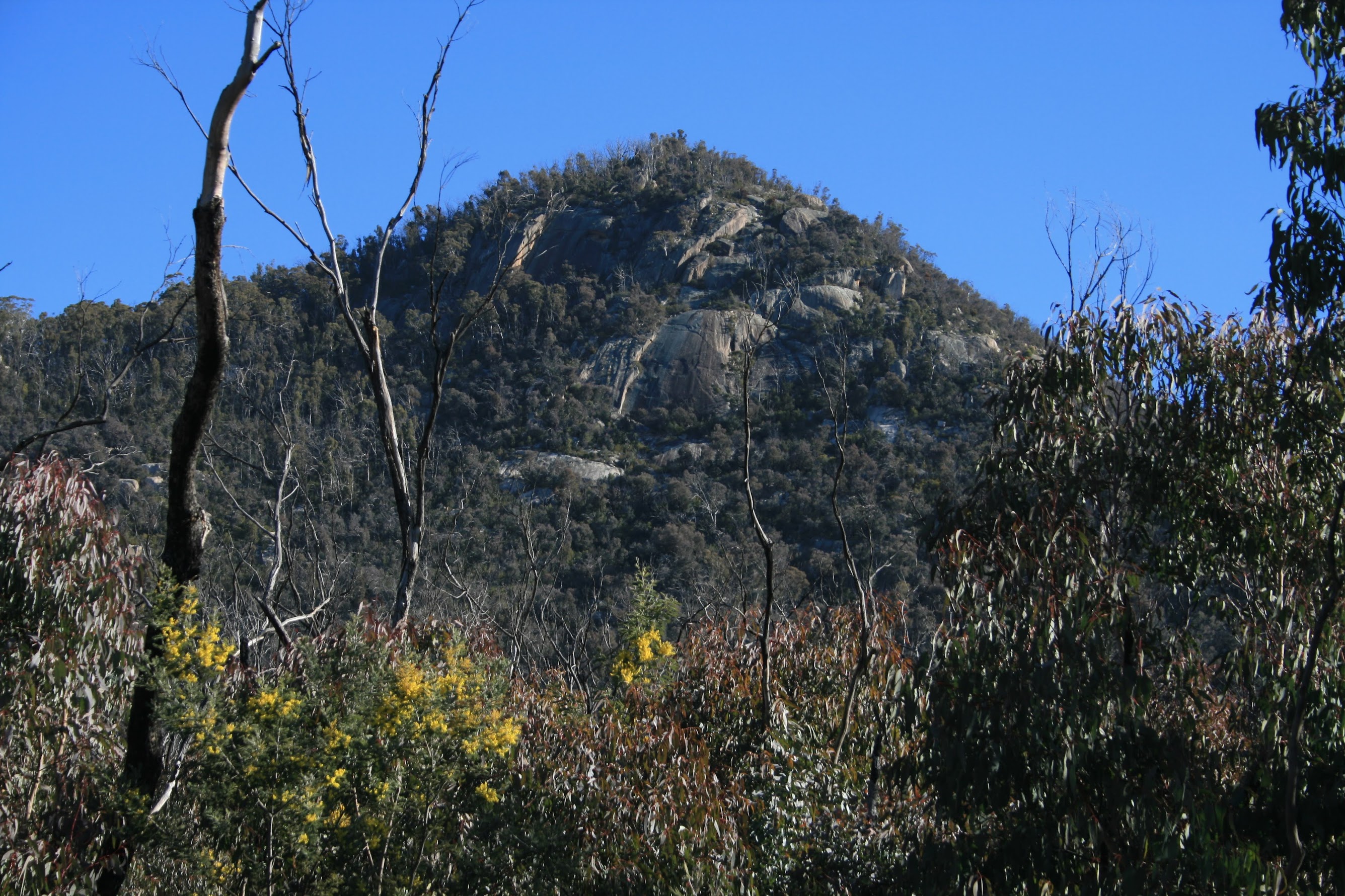
After munch we spent a little time looking for an old hut site. The 30 year old picture was probably the best clue and we lined up the topography. There was a small dam nearby and the fence line - a possibility of W-G site TH2. (PS This was not the site - see 16 Dec 08 for the verified site.) From here we bashed W across the N of SH968 down to join the fire trail on Georges Creek, then down to the ford across Blue Gum Creek. We continued along the road for a further kilometre and, at a gate, did a left turn up towards the towering granite hill that had come into view.
A sweaty 400m climb through scrub followed. Max rightly headed towards a saddle area to the SE of the top of the feature, as a direct approach was just not on. We paused on a rock shelf at the 1230m contour which presented an excellent view SE through S to Mt Tennent, the N end of the boutique range to the W of Bushfold Flats, Deadmans Hill and Booroomba Rocks. This was the same shelf that I'd visited with Chris L on 26 Apr 08. From here, a little further to the NW and we were at the top of the feature.
A magnificent lunch view was beneath us! Contrasts of the rugged Tidbinbilla Ridge to the distant NW; closer to hand treed spurs falling to the cleared 'Booroomba' property with its homestead complex and Blythburn Cottage nestled in its surrounding trees; Blue Gum Creek and rolling hills to Castle Hill; the city of Canberra sprawling in the background with its lakes and Black Mountain tower.
After lunch we moved to the granite top of the objective and peered down the gigantic slot in the top (see pic 2). Our way down was not a reverse out, Max choosing an exit down to the N and NE containing some wonderful granite terraces and ledges. We all 'enjoyed', to a greater or lesser degree, an unhindered slide down a granite chute which left behind skin from elbows and knees and brought various amounts of blood to the surface. At last, however, the slope lessened and we gained the road. We wandered back to the Blue Gum Creek ford, again obtaining great views up to where we'd been (see pic 3).
A brief stop for water and nourishment, then back up to Bushfold Flats. No need to check the waypoint for our next bag, the N Bushfold Flats shearing shed site (W-G TH4), as it was staring us in the face as we arrived at the gate at the track junction (see pic 4). Now I must have been through here several times and not really noticed it - marvellous what you see when you are aware of what to look for.
With the sun westering, we followed the realigned AAWT back up to the junction on the ridge, a wombat waddling across the track near here. Then back down to the Namadgi Visitors Centre, the wattle attracting my attention (see pic 5).
Timings
| Leg | From ... To | Distance | Time |
| 1 | Namadgi Visitors Centre to track junction on N Mt Tennent ridge | 4.1 | 1:10 |
| 2 | Track junction on N Mt Tennent ridge to N Bushfold Flats Hut site | 1.4 | 0:35 |
| Morning tea | 0:15 | ||
| 3 | From Bushfold Flats Hut site, look for second site, walk road to turnoff point | 2.3 | 0:45 |
| 4 | Ascend to top of rock face | 1.7 | 1:40 |
| Lunch | 0:30 | ||
| 5 | Descend to road | 1.9 | 1:30 |
| 6 | Road to N Bushfold Flats shearing shed site | 3.6 | 1:00 |
| 7 | Return via AAWT | 5.8 | 2:05 |
We now know the secret of Max's meanders - he doesn't count the ups and ups in between the start and objective! However, an excellent little walk to check out some substantial granite. Thanks Max, and Barrie, Karen and Henry.
Distance: 20.9km Climb: 1400m. Time: 8.25am - 6.10pm (call it 9.75hrs), with 50mins of stops.
Grading: L/R; VH(15)
KMZ file for Google Earth/Maps: Bushfold Flats and Rock Face above Blue Gum Creek