This walk was organised and led by Max S as a private Tuesday walk:
Coree Creek – Hard – 11 km 400m. Folks, this Tuesday’s wander will be along Coree Creek – why? because it is there and many who have done it before say “don’t”! Seriously, apparently brilliant pre-fires but now much overgrown for the bottom 2-3 km. It may be impractical in which case we will have to abort. The walk will be in the water much of the time and will involve much cutting of blackberries – secateurs is the preferred tool. (The leader may spend much of the time at the back). From Pabral Rd we will walk to where Coree Creek enters the old pine forest and then follow Coree Creek northwards to about Two Sticks Rd, returning by Pabral Rd to cars. About 6-7 km off track, rock scrambling, slippery, thick brush. To see - 3 Falls and maybe some rare trees along Coree Creekk Flats. Weather prediction – Fine, Min 1 Max 16 Meet at W - Cooleman Court – 8.00 am. As usual 4 walkers are required to make this a sanctioned FBI walk.
3 of us met and drove via Uriarra Crossing up the Brindabella road and right down Curries Road just after the end of the black top. Over the ford of Condor Creek and up Pabral Road (a little slippery after last night's rain) to the turnaround at the edge of the native forest.
Walk
Max is well connected - an amount of rain the previous night to swell the volume of water in Coree Creek and a brilliant, blue-sky day. Kitted up differently - long shorts, scrub gloves, soft shoes and armed with secateurs - we negotiated the speed humps down the old fire trail to Coree Creek and turned left. A few snips here and there at the grasping blackberries, but it was more a matter of getting used to walking against the watery conveyor and trying to slip over elegantly. This was new territory for me - my first proper creek walk. And the water was not cold once my feet were numb. It would, of course, be an excellent summer walk, but it was also excellent today - the blackberry growth had not kicked in and it was not stiflingly hot in the generally breezeless creek line.
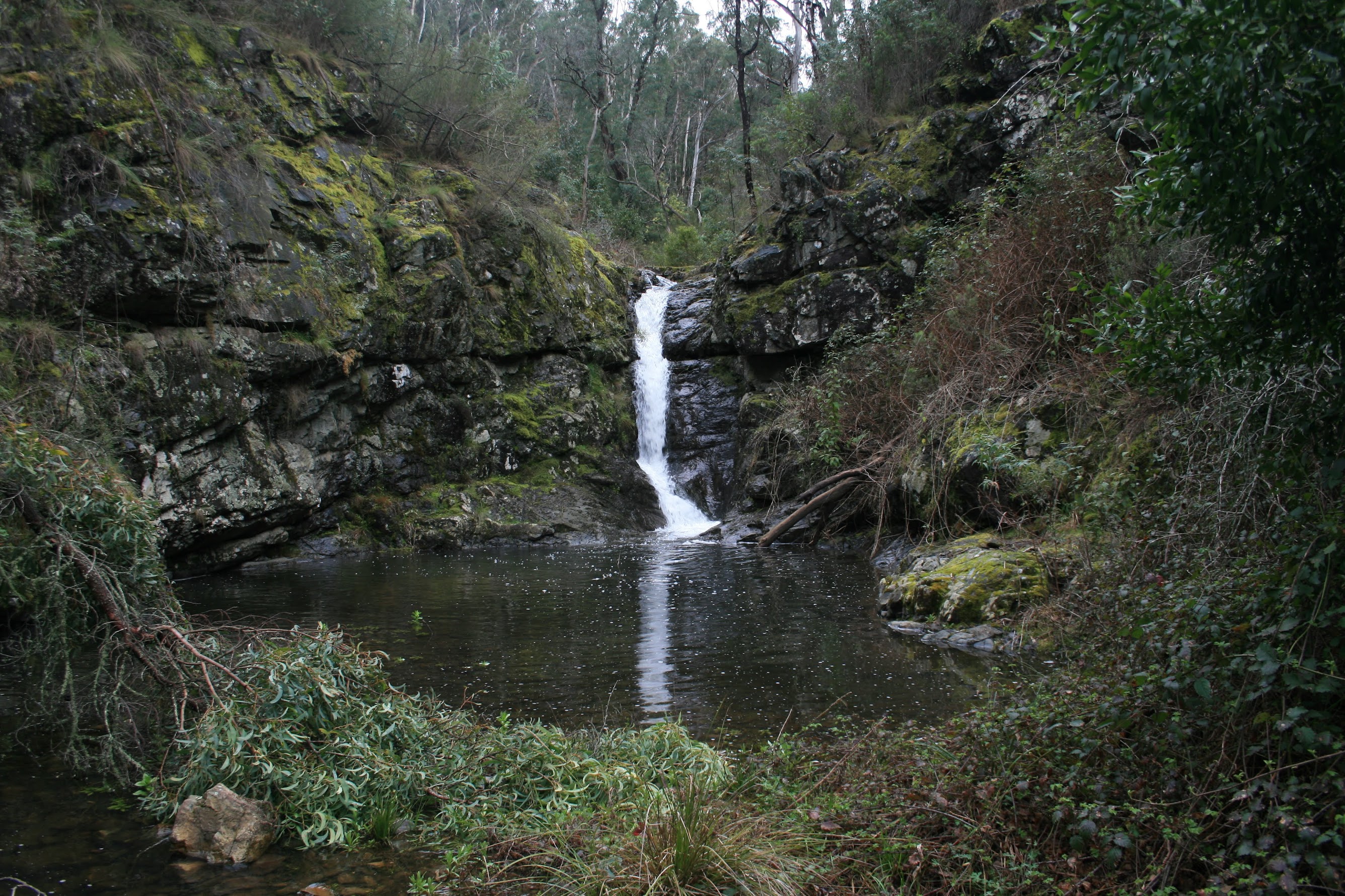
The creek took us generally NE then N. It was truly beautiful, with lush, unburnt forest coming down to the densely vegetated creek sides with the occasional tree fern. The only way was to literally walk the creek bed, clambering over the log jams, wading thigh-deep through the larger pools and focusing keenly on maintaining balance over the slippery rocks. We reached the first, lower Coree falls and pool (see pic 1) which Barrie had described to us previously.
A little further on we negotiated some beautiful cascades (see pic 2), more to my liking as a person fearful of water. Sunny, dry rock shelves in the creek bed presented themselves at the perfect time for morning tea and we enjoyed the different to usual scenery.
Back to our watery path, the sides above us crowded in a little. Spectacular view to the E to the 80r cliffs (see pic 3). Branches and blackberries grasped from the sides of the creek. We tracked N, then NW and W and eventually arrived at more slippery cascades below the main Coree Falls. We recognised our usual exit route up to the S and below the falls and, getting closer, the detailed way we'd come 3 weeks previously. These are certainly quite good falls (see pic 4) and delivering more water today.
We clambered up the N side of them to the massive block and peered down the upper part of the falls, then continued up the creek (in a blackberry canoe without a paddle) to the upper Coree Falls. So my education was complete and, hopefully, I'll never mis-identify any of the falls on Coree Creek again! We crossed to the S side of the creek and found a rocky patch in the sun for lunch.
With slightly dried gaiters, shoes, socks and feet, Max led us back down to the water and we continued our splashing upstream (at times I suspected there was extra, frivolous splashing but my companions assured me that it was just a graceful slip). This upper section of the creek was actually a little annoying - narrowing, less water, more debris. Max hunted for flora specimens. Another party member asked what we were still doing in the creek, so we did spend a little time on dry land as the creek line became more choked.
Eventually the watery profile flattened, the vegetation withdrew first to more open forest and then to lovely creek flats and, around 500m short of the 330kV power line and Two Sticks Road, we U-turned to the SE and gained Pabral Road.
A wander back to the car.
Timings
| Leg | From ... To | Distance | Time |
| 1 | Start to bottom waterfall and pool | 1.03 | 0:42 |
| 2 | Bottom waterfall and pool to cascades | 0.20 | 0:12 |
| 3 | Cascades to morning tea | 0.41 | 0:20 |
| Morning tea | 0:20 | ||
| 4 | Morning tea to main falls | 2.08 | 2:20 |
| Main falls to upper falls | 0.05 | 0.05 | |
| Lunch | 0:30 | ||
| 5 | Lunch to turnaround point | 1.73 | 1:13 |
| 6 | Turnaround point to Pabral Road | 1.13 | 0:33 |
| 7 | Down Pabral Road to car | 3.59 | 0:55 |
A short-course, but more intense walking as one has to watch each step. An absolutely brilliant walk. Thanks Max, and Karen.
Distance: 10.2km Climb: 400m. Time: 8.40am - 3.55pm (7.25hrs), with 50mins of stops.
Grading: M/R,W; M(10)
KMZ file for Google Earth/Maps: Coree Creek