This walk was organised and led by me as a private walk - for me.
Walk
With 40°C forecast for Canberra and the Corin Dam Road closed, Max had to postpone his Stockyard Spur/Stockyard Creek walk. So I took the opportunity for an early morning wander to a couple of nearby Canberra Nature Parks, areas used by Rob H for the CBC Navigation Exercise in 2004 (13 May 04 and 5 Jun 04) which got me equipped to start wandering around.
Walk 1 - McQuoids Hill Nature Reserve track
The map for the McQuoids Hill Nature Reserve is here.
Pulled up off the side of the Kambah Pool Road, through a step-through gate and along the footpad across the paddock to another gate with the Nature Reserve sign. Nice early morning light (see pic 1 and here). Up the hill, a little more direct and quick than last time. Quite nice views all round, including across to Urambi Hills. Down to the NE, back to the SW. A few kangas about and plenty of white cockatoos.
Walk 2 - Urambi Hills Nature Reserve track
The map for the Urambi Hills Nature Reserve is here.
A 5 minute drive across into Glen Eagles and to the end of Cremin Place. Across the golf course to the SE segment of Glen Eagles and around its SW and S sides. Easy walking along the horse trail to the Meredith Cct part of Kambah and finally up the spine of the Urambi Hills, always seen as one drives down and up Drakeford Drive. Reached the N knoll with the seat (see here) and enjoyed the view from it. The way ahead across the grassy top was pleasant (see pic 2). Views to the W down to the quarry at Red Rocks Gorge on the Murrumbidgee River and across to the Bullen Range (see here). Wandered to the trig point on Urambi Hill.
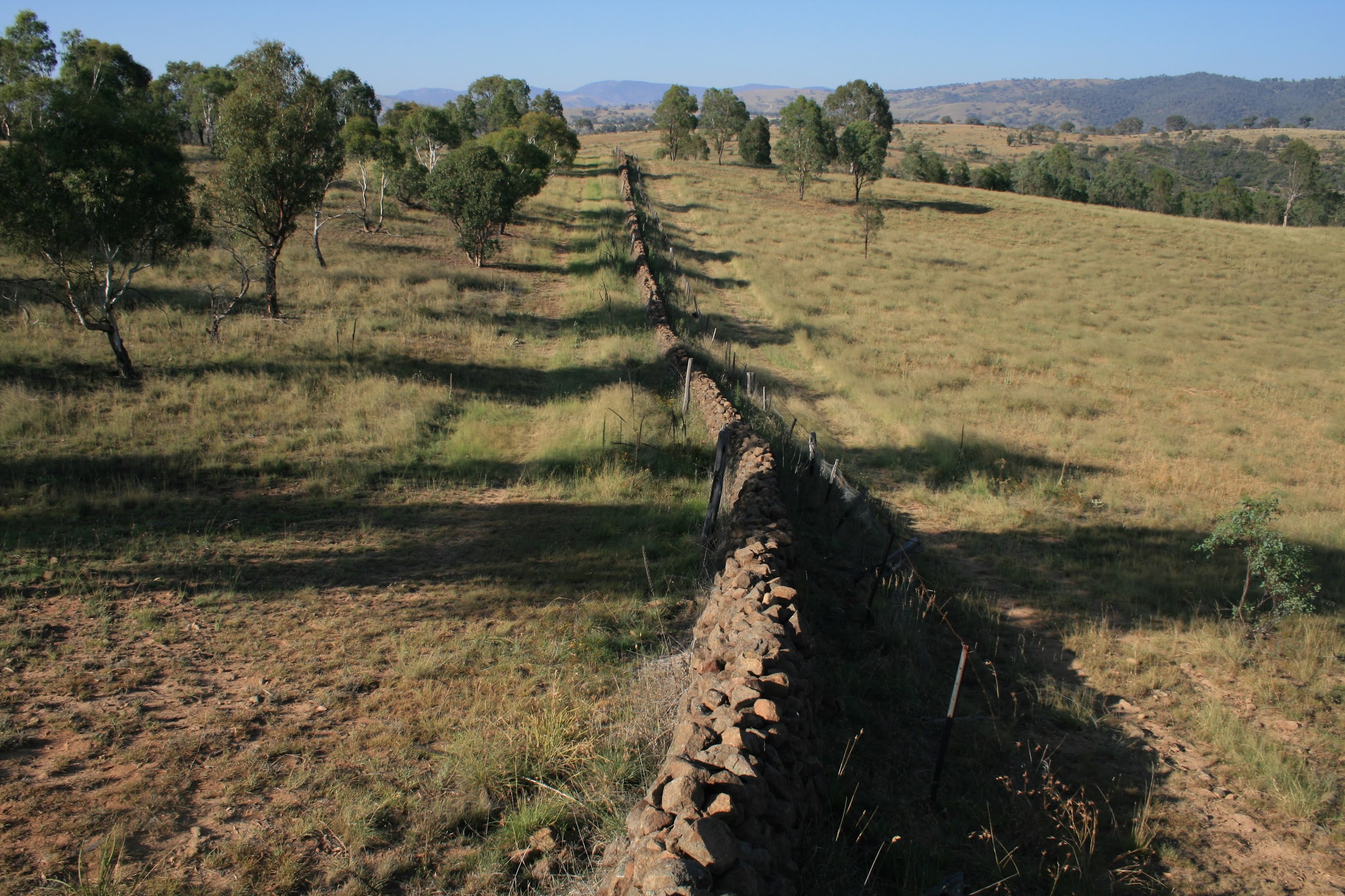
Next down the SE spine towards the spillway of the Lake Tuggeranong dam, curving S to cross Tuggeranong Creek to its left bank. Poked about the bridge. This whole area is a mess of fences and trails, but continuing S I found what I was looking for - the Tuggeranong dry stone wall. The stile was a good point to take a snap (see pic 3). Intrigued by descriptions which had it visible from Athlon Drive, I wandered E along the wall to its end. Well, well - it comes to within metres of the lights at the N corner of Athlon Drive and Ankettell St! Retraced my steps and continued on down to the SW end of the wall near the Murrumbidgee River. Wonderful construction (see here). The Tuggeranong Boundary Marker Complex is ACT Site of Significance T7 and appears on the ACT Heritage Register here.
It was getting warm and I was needing a sip of the iced water in the car, so back and across Tuggeranong Creek and via pads and paths NW between the Urambi Hills spine and the obvious drainage line to civilisation. Retraced my outward route around the perimeter of Glen Eagles.
Something to do on a hot morning ... memories of the CBC Navigation Exercise.
Distance: 11.9km Climb: 250m. Time: 6.45-7.15am (30mins) and 7.20-9.50am (2hrs30mins) with no stops.
Grading: M/E; E(6)
KMZ file for Google Earth/Maps: McQuoids Hill Nature Reserve and Urambi Hills Nature Reserve