This walk was organised and led by me as a combined CBC and Parkway walk:
Saturday 25 July- Chimneys and Thrones of the Southern ACT - M/E-M,ptX. Combined CBC and Parkway ramble. From the Mt Clear Camping Ground car park trot along the W side of Back or Grassy Creek to visit Potters Chimney. Then across the creek onto the Long Flat Fire Trail to try to find an old hut site. The fire trail will take us past a stockyard site and on to Sam Abouds Dunny. From a nearby ford, cross country to Chalkers Chimney. Then NW through the bush to the Naas Valley Fire Trail and John Brayshaws two hut sites. West along the fire trail to the Mt Clear homestead site complex and back to the car. Around 11km + 200m climb. Maps: Colinton and Bredbo 1:25000. Leader: John Evans – jevans@pcug.org.au, (h) 6288 7235. Transport: ~$20. Further details at http://jevans.pcug.org.au.
9 of us headed south in 2 cars to the Mt Clear camping ground car park.
See the proposed track below - click on the thumbnail:
 |
| 2009 07 25 Chimneys and Thrones of the Southern ACT |
The Canberra Bushwalking Club has been kind enough to advertise this walk as a combined CBC/Parkway ramble, so we should get an interesting mix of walkers. No offence to anyone, but CBC walkers should be prepared to enjoy this walk as a ramble with plenty of time to smell the roses. Parkway folk - a great opportunity to talk with experts about bushwalking.
Meet by 8am in the Parkway car park, cnr Sulwood Drive and the Tuggeranong Parkway. We'll car pool from there. Parkway folk - note that we pay the driver. Rug up - it will be cold. Bring morning tea and lunch.
What will we see? 1 W-G BR13, SoS G42 - Potters Chimney; 2 SoS G43 - Grassy Creek Tussock Grasslands; 3 W-G BR17 - Reg Brayshaw's hut site; 4 W-G BR3 - Stockyards site; 5 W-G BR1 - Sam Aboud's hut site; 6 Sam Aboud's Dunny; 7 W-G BR2 Sam Aboud's Stock Pen; 8 W-G BR16 1-3, SoS G47 Chalker's Chimney; 9 W-G BR16 2-3 Hut site; 10 W-G BR16 3-3 Stockyard; 11 W-G BR8 John Brayshaw's 2 hut sites; 12 W-G BR4 Mt Clear tank; 13 W-G BR5 Mt Clear homestead complex.
Timing estimates 8am leave – 1.5hrs drive – 5-6hrs walk – 1.5hrs drive, so back around 4-5pm. That is rubbery, but it does depend on many factors, like how good we are at finding the historic sites, how many roses we want to smell.
Walk
Not a good start as we drove past the sign at Tharwa saying Boboyen Road Closed. I decided that Hospital Creek Hut would be a reasonable alternative and that we'd continue to drive south. No mobile reception to ring the Namadgi Visitors Centre to enquire. But glimmers of hope as we passed a north-bound Government ute and another dirty car. The next road sign said Boboyen Road Open, so back to plan A.
We stopped at the Hospital Hill lookout for the excellent view W into the Bimberi Wilderness and its snow covered peaks. Great signage here. A perfect, crisp blue-sky day.
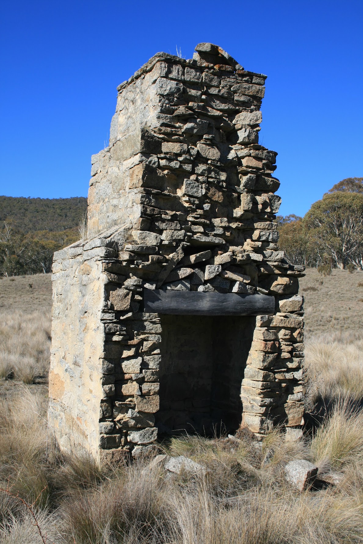
We were an eclectic group, with a range of backgrounds, interests and experience with bushwalking - the perfect mix for an enjoyable ramble. Heading from the car park, the conversations started immediately and we soon veered right off the fire trail along a vehicle track on the W side of Back or Grassy Creek to Potters Chimney (see pic 1). Being well equipped with background material this time, we poked around the creek bank and found the site of the source of the slate used to construct the chimney.
Across the broad, swampy, dry creek bed and onto the Long Flat fire trail, following it to the right angled bend where it begins to climb away from the creek and its T-intersection with the Burnt Hill fire trail (the Burnt Hill ft is not marked on either the 1st or 2nd edition 1:25000 Bredbo maps). Near here we had a location for a hut site, but could not find it at the given location nor match anything against the profiles in the 30 year old photo. However, I had an alternative location, so we wandered along between the creek lines and found the granite stones of the chimney of Reg Brayshaw's hut (see pic 2). The photo now matched perfectly, the fire trail in it being the Burnt Hill ft, not Long Flat ft. Stretching up the gentle slope above the hut site, one could possibly imagine a lone quartz chip might indicate the knapping site (see pic 3). We had walked across and near much of the Grassy Creek tussock grasslands.
Swinging N onto the Burnt Hill ft, we tromped back to rejoin the Long Flat ft and wiggled up the hill. Another abortive search for a stockyard site at a given location near the ft, so morning tea was enjoyed. Later, just near SH1247, the Stockyard appeared (see pic 4). A bag for sure, as it matched the 30 year old photo. A fair way away from the background material stated location. Funny, I've walked past here at least twice before and can't remember noticing the yards.
On to Sam Aboud's dunny (see pic 6), which amused party members just as much it did me when I first saw it. Mike told the correct story of its construction. Whether it was better armed with background material, or sense to realise that a dunny would be near (but not too near) a hut site, or (as was this case) having an excellent spotter like Mike in the party, Sam Aboud's hut site turned up where it should have been (see pic 5). On a roll, we wandered down into the nearby tussocky creek bed and found Sam Aboud's Stock pen in quite good order (see pic 7).
From here we walked back to pick up our gear, down the fire trail to the ford, then NE down the creek line to Chalkers Chimney (see pic 8). A great sight as we approached - blue sky, open tussocky grasslands with timber running up to Mt Clear and the large boulders near the chimney beckoning us for lunch. But first an explore - the stone footpath identified in the grass leading to the adjacent Hut site (see pic 9) and, a little way up the slope, the Stockyard site (see pic 10). A leisurely lunch on the warm boulders.
Away again, this time through the open timber to the NW. Not a good line navigated by the leader (at least one living legend in the party picked this up, didn't you Janet), slipping off the side of a spur and hitting the Naas Valley fire trail to the west!! of the 2 fords. With the next site to the E along the fire trail, a couple of unplanned crossings of the Naas Creek. Someone has placed a convenient piece of timber near the E ford, so we were across dry footed.
Visited John Brayshaw's two Hut sites (see pic 11 and pic 12). These are also known as Barrett's Hut sites.
About turn and back over the fords. At the second we enjoyed sticks of thick ice from a puddle near the ford. It was 2.30pm and the sun was shining, but a cool day at the shaded pool.
So back to the Mt Clear homestead area (see pic 13), passing by the Mt Clear tank. Great facilities now, even a modern loo (to make it a two dunny day). A little disappointing in that nothing is left of the original homestead complex - it must have been difficult for the last lessees to move out. But I understand that the original policy was to remove modern structures when the National Park was declared. You can see patches of flag stones set in concrete (maybe the original patio) and maybe the site of the Cowbail and animal pen down the fenceline.
It was getting cool and cloud cover coming over, so back to the cars.
Excellent conversation in our car coming back on pre-walk briefings. Regularly walking with extremely competent companions on Tuesdays has perhaps made me a bit slack. A concise briefing, no matter who is in the party, must be my norm.
We stopped at the Tharwa Store on the way back and Val J kindly gave me contact to a land owner for Tuesday week.
Great fun - thanks Annie C, Dick M, Gavin F, Janet E, Jürgen P and Nina V, Mike B and Tarja S.
Distance: 14km Climb: 250m. Time: 9.35am - 3.15pm (5hrs 40mins), with 60mins of stops.
Grading: M/E-M,ptX; M(8)
KMZ file for Google Earth/Maps: Chimneys and Thrones of the Southern ACT - combined CBC and Parkway Ramble