 |
| track a |
 |
| track b |
 |
| track c |
7 November 2009 Mt Namadgi
Maps: Yaouk and Rendezvous Creek 1:25000
Getting There
This walk was organised and led by me as a CBC walk:
Saturday 7 November - Mt Namadgi - L/R. An invitation is extended to you to join my third annual birthday champagne luncheon on Mt Namadgi. Although the position of cork catcher has been filled, stemware polishers and strawberry cutters are required. In and out the easiest way via Middle Creek and Big Creamy Flats. Around 26km and 800m climb. Maps: Yaouk and Rendezvous Creek. Limit of 8. Leader: John Evans - jevans@pcug.org.au, (h) 6288 7235. Transport: ~$15. Further details at http://jevans.pcug.org.au.
10 of us met at Kambah and picked up another party member at Conder. We dodged the roos to Yankee Hat car park.
Further Information
Civil twilight: 07/11/2009 Rise 0527 Set 2007.
Philip G is going in overnight the weekend before, so we'll have an up-to-date report on conditions to sponge off. Philip reports that the going is a little tighter and slower than I've estimated in the route card below, which is based on 7 Nov 08. And ants are prolific.
With 14 now booked, that's a Jeroboam-sized party. We'll need an assistant cork catcher. The chief cork catcher tells me he has been practising in his back yard. If anyone would like to nominate for ACC, lessons could be arranged.
Booked are - RT, PJ, KT, TB, JH, JR&M, KC, CR and CB. Rob H is going in on Friday 6 to set the luncheon table and do other interesting things. MS and TU are joining him.
Mt Namadgi is the 6th highest named hill in the ACT.
Photographs
Access all primary pics here. Access all Picassa-stored pics here. All thumbnails in the walk report are active - click for a larger picture.
Walk
|
|
|
For the third year, a great day to an iconic destination to have a bit of birthday bubbly. Either I'm getting slower or the regrowth is getting thicker, because today's wander was a little slower than on previous occasions (7 Nov 08 and 10 Nov 07). But a great group of 10 companions, with another 3 to greet us on top.
Some small grumblings from those who chose to go out on the town the night before and a few misty showers as we drove out, but both cleared up. The howls of the wild dogs greeted us at the Yankee Hat car park.
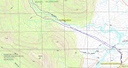
With the cloud clearing from the top of Mt Namadgi and the sun striking the rocky top of Mt Burbidge, we were away by just after 6am. The Gudgenby grasslands look a picture at the moment and each pouch sports a joey. A wander down the Yankee Hat Walking Track to cross the bridge over a nicely flowing Bogong Creek, then generally across the grasslands into the mouth of Middle Creek. We dropped down to pick up the old vehicle track, as it ends at a spot to cross Middle Creek with an interesting signed feature immediately on the left bank. (Speaking of creek banks, let me have my little say. To me, it makes no sense to talk about a left bank without knowledge of the fact that stream/rivers are 'sided' when facing down the direction of water flow. Adding the designator 'true' - as in true-left - seems superfluous to me.) From here we paralleled the creek around 100m above it, through open forest with plenty of animal pads. A good 7.7km in 2hrs12mins, only a fraction over the plan. With breakfast a dim memory, we paused for morning tea.
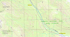
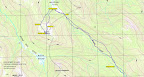
Things went a little wrong after that. Relying on my memory rather than the plan, I went higher above the creek and struck pick-up-sticks. Atrocious route selection, as climbing over the fallen saplings sapped extra energy. Reaching around the 1400m contour SW of Mt Herlt and there being no relief, I indecisively dropped back down towards the creek (to within a few tens of metres of our better homeward track). The last 1km to the Middle Creek/Creamy Flats Creek saddle, which Philip G on last weekend's trip had warned me was a bit tighter, was a relief. The 3.4km of this leg took 2hrs40mins, a mite longer than the planned leg 4 above of 1hr35mins, so our timing was shot to pieces. The gory detail is graphically represented in track c.
| Nice to break onto Big Creamy Flats, pause for a moment or two (standing to avoid the ants), then wander down its SW edge to a point I'd calculated would give us a better angle of attack to the Namadgi spur than last year. Up we went, nearly 300m, but yet again I curved too far towards the Namadgi top (but not as much as last year) rather than heading to the broad saddle in the spur. Grand view back behind us down to Big Creamy Flats under the Mavis Ridge. |  |
A little haste, as in a phone call from Rob to Jen the previous night he said they would leave at 12.30pm
At 12.25pm we reached the significant site near the top which had consumed the advance overnight party's interest. The familiar figure of Max was spotted in the distance. They generously turned about and the 14 of us met on the top to share a little champers from genuine (plastic) champagne flute stemware. With John H (the incumbent cork catcher) unable to make the trip, Kerrie T stepped up and performed an excellent job. Even bare footed, she watched the cork perform its graceful arc, vigorously pursued it down into the nearby bushes and gleefully retrieved it. An energetic performance - no littering up here. Thank you also to other kind friends who had carried in birthday gifts - a limited edition reprint of John Gale's Canberra: Its History and Legends, a tin of the ubiquitous beetroot (looking very much like a mini-cake) topped with a musical candle, yummy chocolates and freshly made banana cake. Why didn't they also carry them out for me?
| The view from the top of Mt Namadgi is, as always utterly magnificent! My attention first went to the NW, with Licking Hole Creek dropping down to the green of Cotter Flats. The Kelly Spur is on one side and the Namadgi spur on the other. Coronet Peak pokes over the end of the spur. |  |
| To the NE you see the Mavis Ridge with Mt Orroral up the back of it |
|
| and |
|
It will continue to consume my attention until I walk that middle bit between Mt Mavis and Mt Herlt.
| In my opinion, to the S is the iconic view in Namadgi National Park - Mt Burbidge, Mt Gudgenby and the Scabby Range, |
|
| SH1733, Mt Kelly and the Kelly Spur (scroll right, it's a wide panorama) |
|
| and |
|
| More distant hills are also grand - Mt Murray, Murrays Gap and Bimberi Peak over the Kelly Spur |
|
| And so back to where we started - Namadgi spur with Coronet Peak at back |
|
| and (scroll right, it's a wide panorama) |
|
| The southern Brindabellas forms a lovely backdrop. |
|
| Rob, Terence and Max left us to our lunch and we watched them wander down the Namadgi spur with their overnight packs and disappear down towards Big Creamy Flats. However, 1.15pm was soon upon us and we needed to begin our return. |
|
Our track down was a little better, heading to a waypoint on the Namadgi spur which then allowed us to descend along the left bank of the small stream flowing (today) down to Big Creamy Flats. Must use this as the way up next time. Heading up the Flats we were surprised to find the other party behind us. We graciously decided to wait for them near the saddle and I schemed to tag along after them. I was a bit wacked after the happenings of the last few days.
Rob, then Terence, led us on a great route home. From the saddle to the Middle Creek junction, we were mostly close to the creek, just skirting up around the couple of flats. Vastly superior to my inward route and the way to go for next year. From the junction we crossed to the right bank of the creek and finished up on the lower terrace of the Burbidge spur, although I would think that our inward leg from crossing Middle Creek up to the Middle Creek junction was easier going. A combination of the two would provide the best of the best - nearly a breeze!
Back to the cars just before 7.30pm. 13 companions for a bit over 13hrs wandering. Some young ones went on to parties and dancing. I came home and went to bed.
An excellent day. Thank you to Tony B, Cynthia B, Karen C, Jenny H, Peter J, Chris R, Jacqui R, Mark S, Rob T and Kerrie T. And to Rob H, Max S and Terence U.
Distance: 26.3km Climb: 800m. Time: 6.10am - 7.25pm (13hrs15mins), with 1hr10mins of stops.
Grading: L/R; VH(15)
KMZ file for Google Earth/Maps: Mt Namadgi
Back to Walks Index
This page last updated 19Nov09


_t.jpg "The party's over (photo courtesy of Karen C)")