 |
| track a |
 |
| track b |
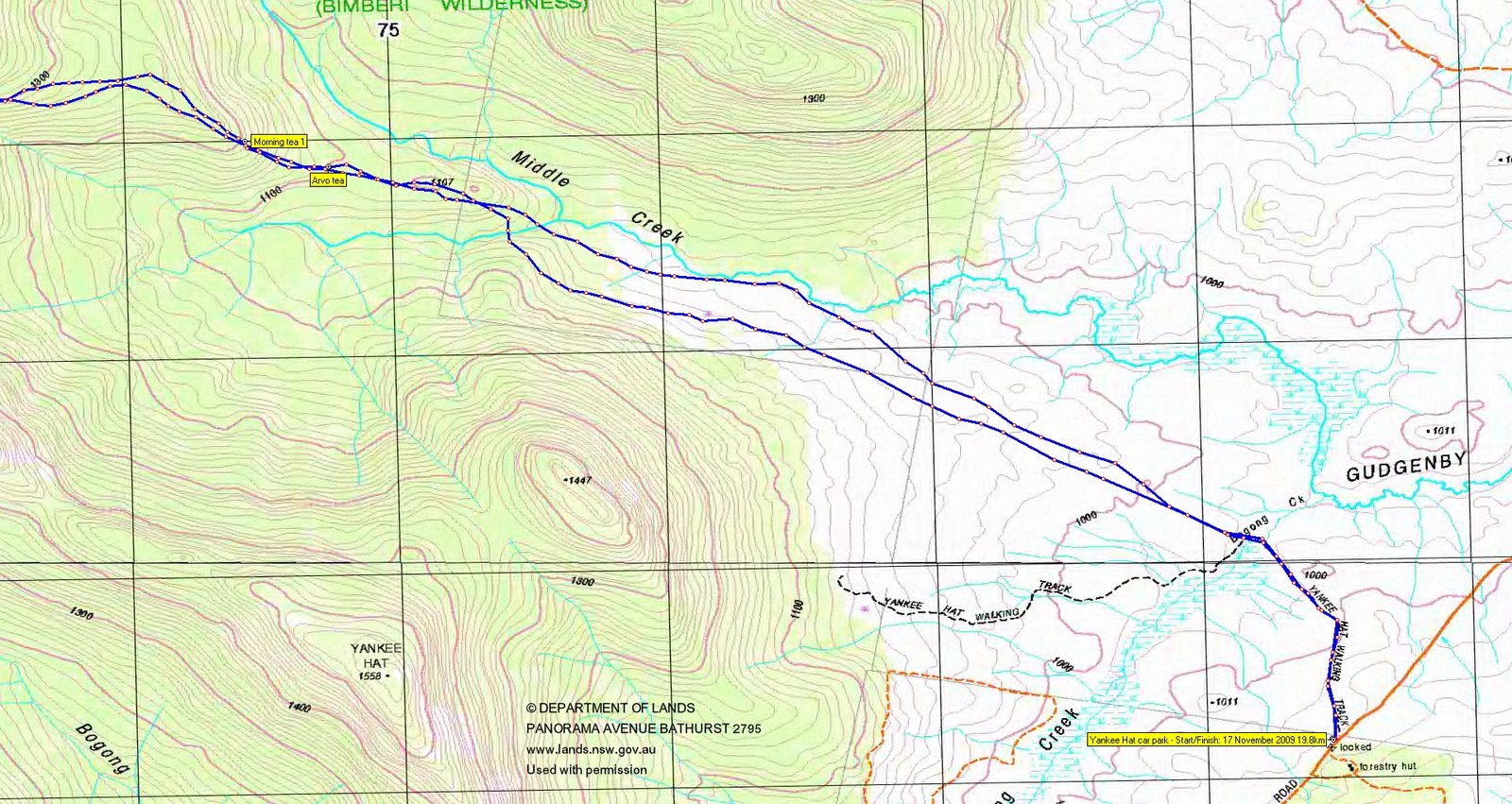
17 November 2009 Mt Burbidge
Map: Rendezvous Creek1:25000
Getting There
This walk was organised and led by Max S as an ad-hoc FBI Tuesday walk:
Folks The target is Burbidge, well known to all. We were beaten at the last attempt but by using the knowledge of others a new route by which to attack the rock summit has been planned. Note - some is unknown to me. Expect a hard walk, 20 km 800 m, probably 8 - 10 hours. Weather - fine, 28 deg C as of today Meet at K 6.30 am Usual FBI conditions - 4 to be a sanctioned walk NOTE - This walk will not operate under the same conditions as last week's guest leader Karen provided - there will be no in car quiz to keep passengers occupied, no free handouts or books to read! There will be no morning or afternoon tea pies or shop coffee!
3 of us met at Kambah. We picked up a fourth at Conder and motored to the Yankee Hat car park. Surprisingly, south from Naas it was still green - they must have had a good dump of rain from the thunderstorm that went round to the south of Canberra last week. The Gudgenby grasslands were still a (green) picture.
Further Information
Mt Burbidge is the 10th highest named hill in the ACT.
Photographs
Access all photographs here. All thumbnails in the walk report are active - click for a larger picture.
Walk
|
|
| 28degC was the forecast for Canberra, so not too bad a day to tackle this little hill which we didn't quite reach on 2 May 09. Away by just before 7.30am, heading across the green grasslands into the mouth of Middle Creek. Not as many roos as one would expect - perhaps the two wild dogs had something to do with it. Max stopped to do something and I took over the lead, following a footpad too high and causing us to have to drop down to cross the S arm of Middle Creek which rises at Bogong Gap. Still, we reached the fenceline after 4.5km in 1hr5mins. We headed across the first terrace of the Burbidge spur, crossed the 1100m contour and began the climb towards the second terrace. Around 1200m Max allowed us our first morning tea (8.50am). An excellent spot on a granite tor with views to the NE down over the main arm of Middle Creek and to the SE to Yankee Hat. |  |
Continuing up the spur onto the second terrace, at about the 1300m contour we began to sidle across to the S arm of Middle Creek. Last time we'd gone straight up the Burbidge spur and run into horrendous regrowth and pick-up-sticks. Some nice open forest for a while by the creek at around UTM 55H 672507-6044764 (GDA94). We crossed to the right bank of the creek for a while, crossed back and enjoyed morning tea 2 just up off some creek flats within about 600m of Bogong Gap.
| A scrubby leg next as we headed sort of half way between Bogong Gap and Mt Burbidge, doing a right turn when a suitable way opened up to get us up onto the ridge. The slabs took us to just SE of the top. We paused for breath near the crest, gazing SW to the eastern arm of the Scabby Range which takes one's eye across Bogong Gap to Mt Kelly. |  |
| Collective breaths gathered, we wandered NW to the tor with the cairn atop. |  |
| From here we went a few tors further to the NW to see down onto Rotten Swamp. This really is a marvellous place! There's a breath-taking view from Mt Kelly, the Kelly Spur and Mt Namadgi over Rotten Swamp. |  |
| Only one cricket pitch (strip of hessian to promote sphagnum regrowth) remains and the place is still a pretty green. So, over the last 2 months, we've been privileged to visit the three high hills at the core of Namadgi National Park - Mt Kelly (19 Sep 09), Mt Namadgi (7 Nov 09) and, today, Mt Burbidge. |  |
| We retraced our steps a couple of hundred metres back along the ridge top to luncheon granite. A glorious day, with the breeze just taking the edge off the bite in the sun. More huge views, to the NE the Mavis Ridge between Mt Mavis and Mt Herlt (this will consume me until it's been trodden!) and to the SE a striking view of a rocky Burbidge pinnacle with the vivid green Gudgenby grasslands to its left and the Yankee Hat ridge and Mt Gudgenby and The Fortress to its right. |  |
| To the NW, from where we'd come, we could still see Mt Kelly and Mt Namadgi. | 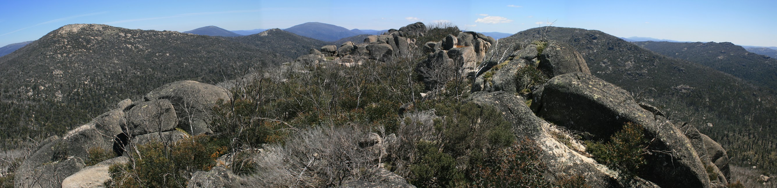 |
It's a real joy to take in these views - makes the blood, sweat and tears (tears of clothing, not tears in the eyes) worthwhile. It certainly adjusts one's view of one's (in)significance, too.
| Lunch over, we continued further to the SE, to the top of the huge granite bulb which plunges off the side of the ridge top. Excellent views to the SE and S. |  |
A crashing leg 200m down through dense regrowth reaching up to the starkly grey skeletons of the 2003 burnt trees.
A stop for water around 1.5km back down the creek, having enjoyed the stroll through the open forested area again. The plan then was to contour across to the crest of the main Burbidge spur, but at the 1400m contour we struck pick-up-sticks so looped around the area to the S and E. It's obvious on track b. Back on the crest of the spur around 1250m contour, arvo tea on reaching the first terrace. Picked up the footpad which, at the fence crossing, becomes very distinct. It leads very clearly to the crossing of the S arm of Middle Creek (a handy point to have UTM 55H 675550-6043594 (GDA94)), as the track then becomes indistinct from here out into the open. Picked up and followed the old vehicle track out for a while, then cut up and across the grasslands to the car.
| Turning back, we could enjoy the view to a satisfying day's destination. |  |
Thanks Max. A great destination with excellent views and at a great pace. Excellent company from Eric G and Mike B (and chilled Tim Tams!).
Distance: 19.8km Climb: 850m. Time: 7.20am - 4.20pm (9hrs), with 1hr of stops.
Grading: L/R; H(14)
KMZ file for Google Earth/Maps: Mt Burbidge
Back to Walks Index
This page last updated 10Aug22