|
|
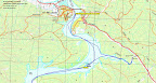
| track a |
|
|
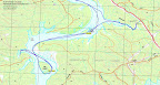
| track b |
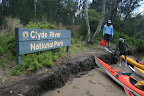
15 December 2009 Clyde River kayaking
Map: Nelligen 1:25000
Getting There
This walk was organised and led by Max S as an ad-hoc FBI Tuesday 'walk':
Canoe trip - 15 December - Clyde River. From Nelligen we will paddle down stream to the bridge or thereabouts, exploring a tributary on the way. The exact route/distance will depend on tides and numbers Mike B has paddled this area and will guide, if available on the day. A test of interest at this stage - who would like to come, own kayak, transport of kayak? Should be leisurely.
Further Information
Mike B has offered me and an engine room partner the use of his double kayak.
Photographs
Access all primary pics here. Access all Picasa-stored pics here. All thumbnails in the walk report are active - click for a larger picture.
Walk
|
|
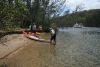
This is a very smooth guided adventure company. Tour leader Max; paddling consultant Mike; transport and technical example Mark; paddling companions Rod and Rainer; engine room and commentary by Karen.
| We launched in various styles from the Nelligen boat ramp and paddled down the Clyde River via various routes (I had poor rudder control in the double) into Sheep Station Creek. A quite nice lower stretch, with mangroves on one side. Narrowing quickly, it emerged under the Kings Highway via a large 3-pipe culvert, so we handed our way through for a look. Dead end for further paddling. |
|
| Back down Sheep Station Creek we paddled over to the SE side of Little Island for a morning tea stop. |
|
| Our next leg took us a further 3.5km down the river, around Big Island and onto its E side for lunch. Tiny crabs on the rocks and sand amused us. Mike send off a Spot signal and the resulting emailed location corresponded with my GPS waypoint (just as well - good for confidence levels, in both devices!). A pleasure luncheon boat cruised past and, just for a moment, I envied the cold drinks and seafood which were no doubt being served. The method of travel was attractive too, as my left arm was beginning to ache. |
|
After lunch Max and Karen swapped so she could have a paddle in a single. I took the rear seat as a change and it was very pleasant to paddle along without having to focus on the rudder. I mostly resisted the temptation to cease paddling and enjoy the ride. Wisely (in my assessment as I was tiring) we turned back upstream and visited a small side waterway with an oyster lease at its mouth. Max and I enjoyed a little 2.5km return to the lunch spot to collect a forgotten glove, eventually rejoining the flotilla at a short arvo tea break on Little Island.
Karen kindly rejoined me in the double and, against wind and tide, steered me flawlessly back to Nelligen.
With boats cleaned and repacked on cars, coffee and cake at a local shop were welcome.
Excellent thanks Max (even though my left arm has fallen off). Employ Mike as a consultant again. Karen's not bad in the engine room (although you talk less when we had a paddle together) and Mark was powerfully elegant in his vessel. Thanks also to Rod and Rainer for company.
Distance: 20.6km Climb: 0m. Time: 9.40am - 3.10pm (5hrs30mins), with
1hr of stops.
Grading:
E (if you're a kayaker)
KMZ file for Google Earth/Maps: Clyde River kayaking, but it's a bit flaky as the GPS was in a dry bag in a storage compartment of the kayak.
Back to Walks Index
This page last updated 16Dec09
_t.jpg)