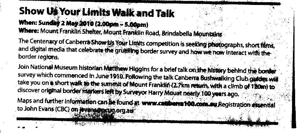
2 May 2010 Show Us Your Limits - Talk and Walk
Maps: Tidbinbilla and Cotter Dam 1:25000
Getting There
This walk was organised and led by me as a CBC-supported, ACT Government-sponsored Centenary of Canberra event. Drive via the Brindabella Road to Piccadilly Circus, then via the Mt Franklin Road to the Mt Franklin car park. Approximate distances from the T-intersection of Brindabella and Uriarra Roads are 9.5km of sealed road, then a further 8km on unsealed 2WD (provided the weather has been kind) to Piccadilly Circus, then a further 19.5km along narrower unsealed road. Park in the Mt Franklin car park. Walk 400m up a vehicle track to the Mt Franklin shelter to arrive by 2pm.
Further Information
Event for the ACT Centenary of Canberra event 'Show Us Your Limits'. Participants register at jevans@pcug.org.au and drive to the Mt Franklin car park. ALL PARTICIAPNTS WILL BE REQUIRED TO SIGN A CANBERRA BUSHWALKING CLUB ACKNOWLEDGEMENT OF RISKS AND OBLIGATIONS FORM. After listening to talks (2-2.30pm) and bring and share arvo tea (2.30-3pm), CBC members will guide walks as follows:
(all border marker locations are UTM 55H, MGA94 datum) ALL border markers to be visited are marked with at least 1m of blue tape streaming from a nearby tree/shrub. This tape will be retrieved on Sunday arvo.
Walk 1 - return to your car from the Mt Franklin shelter Click here to print your personal 1-page guide
Distance: 400m Climb: down. See border markers R55 (660116-6071083), S55 (660054-6070976) and T55 (659977-6070789).
 |
| Walk 1: click thumbnail for detail |
'Walk' 2 - drive out Click here to print your personal 2-page guide
Distance: park at various points and a few metres walking on the drive out. See border markers B54 (661041-6076257), Y53 (661448-6076978), E53 (662408-6079488) and E51 (663500-6085660).
A. At 6.7km from Mt Franklin, pull off the road to the left (west) at the track to Snow Gum arboretum (burnt in 2003). Walk a few metres to border marker B54 (661041-6076257).
B. At 7.5km from Mt Franklin, you'll pass border marker Y53 (661448-6076978) on the left (west) graded edge of the road.
C. At 11.3km from Mt Franklin, turn right (east) into Chalet Rd/Bendora Arboretum car park. Walk a couple of metres to border marker E53 (662408-6079488). Return at another time to walk the 3.5km return and 80m climb to Bendora Arboretum - it is the only extant ACT high country arboretum and is magnificent.
D. At 19.5km from Mt Franklin, visit border marker E51 (663500-6085660) at Piccadilly Circus. Maybe park on the open verge of the road on the right (east) as you approach Piccadilly Circus.
 |
 |
 |
 |
| 'Walk' 2: click thumbnails for detail (right map segment not contiguous) | |||
Walk 3 - Mt Franklin shelter to Mt Franklin trig and return Click here to print your personal 1-page guide
Distance: 2.7km return Climb: 120m. See border markers Q55 (660284-6071212), P55 (660445-6071312), O55 (660545-6071405), N55 (660640-6071411), M55 (660729-6071464), L55 (660850-6071540), 15 Mile (approx 660901-6071563), K55 (660911-6071564), J55 (660960-6071596), I55 (660970-6071652), H55 (660970-6071720), Mt Franklin Trig, old Austin A40 ski tow, Mt Franklin interpretive signage, huge views down to the wild Cotter River valley.
 |
| Walk 3: click thumbnail for detail |
Walk 4 - (drive 2.5km on the way home to Aggie Gap) Aggie Gap to Mt Aggie and return Click here to print your personal 1-page guide
Distance: 2.3km return Climb: 90m. See border markers Y54 (660423-6073123), X54(660306-6073266), W54 (660309-6073350), V54 (660310-6073515), U54 (660304-6073711) and T54 (660345-6073898). Interesting geology and fantastic views from Mt Aggie west into NSW and the Goodradigbee River valley and beyond.
 |
| Walk 4: click thumbnail for detail |
Walk 5 - (drive 16.2km on the way home to Bulls Head shelter) Around Bulls Head picnic area Click here to print your personal 1-page guide
Distance: 1.3km return Climb: 30m. See border markers E52 (663917-6082542), F52 (663809-6082343), G52 (663670-6082287), H52 (663583-6082247) and I52 (663424-6082192). Come again some time and have a picnic.
 |
| Walk 5: click thumbnail for detail |
I'll have that with the lot
Walk 3, Walk 1, Walk 4, Walk 2A, Walk 2B, Walk 2C, Walk 5, Walk 2D.
Walk Leaders - Keith T, Jenny H, Mike B, Peter J, Karen C, John E.
CBC condition - 1 CBC member for each 6 members of the public.
Civil Twilight (just see in ideal conditions) from GeoScience Australia is Rise 0615 Set 1746. A more relevant indicator of Sunrise/sunset from GeoScience Australia is Rise 0630 Set 1735.
Photographs
Access all primary pics here. All thumbnails in the walk report are active - click for a larger picture.
Walk
What a fabulous arvo! 31 of us gathered at the Mt Franklin shelter. It was a real credit to all who drove in and participated with gusto. We were blessed with an absolutely perfect day, weather-wise and all-other-wise.
Dan W from the Chief Minister's Department introduced the afternoon. A huge thanks to him for pulling this all together, especially after he'd planted a hundred trees at the Greening Australia project in the morning (there were 250 people involved).
Matthew H then introduced us to the ACT border survey project which began 100 years ago. This guy is indeed an oracle! He has a love for the ACT high country and beyond, and an intimate and experiential knowledge of it. You really aught to get hold of his book, which covers the border survey and other interesting topics: Rugged Beyond Imagination - Stories from an Australian mountain region, Matthew Higgins, National Museum of Australia Press, Canberra, 2009.
I then had the privilege of introducing the other 5 Canberra Bushwalking Club guides. Each is a living legend in their own right and has a wealth of experience and knowledge of the Namadgi National Park and beyond, and of bushwalking. If you're into this stuff, you'd not do better than to join CBC and to learn from them.
We had a bite of arvo tea and a chat, then set out up the hill. I'd showed some folk border marker T55 at the car park and we'd all seen the fairly unimpressive S55 at the corner of the new tank stand. Up the track a little we headed into the bush to border marker Q55 and Matthew gave us further insight into the day's topic. Again at O55 and N55. We were all experts by now, so gave M55 a miss, merely glanced at L55, 15 Mile marker, K55 and J55 as we walked past, and headed to Mt Franklin trig. More background info from Matthew, then down to see the Austin A40 ski tow. By now it was 3.45pm and we could feel it getting cool as we stood in the shade.
So we returned to the Mt Franklin shelter, were some us us headed home (with walk guide sheets and perhaps to return!).
 |
 |
 |
| 1 Matthew Higgins' introductory talk at the Mt Franklin shelter | 2 Some of the 31 participants walk towards Mt Franklin | 3 Some of the 31 participants walk towards Mt Franklin |
11 of us went on to park at Aggie Gap. A brisk stroll up the Mt Aggie Walking Track, bypassing the border markers off in the scrub, but viewing V54, then U54 out in the open overlooking the Goodradigbee River valley and, finally, T54 at Mt Aggie. Fabulous views and stricking evening light, combined with the interesting geology of the area. We left Ben the photographer there - but he is an experienced member of the ANUMC, was suitably equipped including with a head torch and (because he is an experienced walker) rang through to me when he got back to town.
So that was the end of a too-sort afternoon. Everyone who went out came back alive, we saw no abandoned cars as we drove out in the dark and everyone, I think, had a great time.
Thanks to Peter P, the ACT's Place Names Officer, who was on the walk and later provided information that the 3 surveyors have been recognised, with the portions of the ACT border that they surveyed having recently been officially named after them - the Sheaffe, Mouat and Johnston Lines. See http://www.legislation.act.gov.au/di/2010-50/current/pdf/2010-50.pdf.
I'd like to acknowledge the CBC guides (Jenny, Karen, Keith, Mike and Peter) who did a heck of a lot of background work, including each being GPS equipped with our possible 31 points of interest, generally watching over the flock and pulling in the tapes we'd put up yesterday (thanks heaps Keith and Mike) - the principle is 'leave nothing but our thanks').
The icing on the cake for me was to be shown the 11 Mile survey blaze and a 7½ Mile from Piccadilly Circus blaze for the Mt Franklin Road. In A 1010 - P51 to B54 - FC18 sheet 13 ![]() - (PDF 13.3 mb), the 11 Mile survey blaze is recorded as 45, broad arrow, R, M, 11.
- (PDF 13.3 mb), the 11 Mile survey blaze is recorded as 45, broad arrow, R, M, 11.
 |
 |
| 4 Matthew H shows a couple of us the 11 Mile survey blaze | 5 7.5 Mile blaze for Mt Franklin Road |
Distance: 3.7km (Mt Franklin) + 2.3km (Mt Aggie) = 6km Climb: 100m (Mt Franklin) + 100m (Mt Aggie) = 200m. Time: 1.45 - 5.20pm (call it 3.5hrs).
Grading: S/E; E(6). Those new to walking could find these walks 'moderate'.
KMZ file for Google Earth/Maps: Mt Franklin Talk and Walk
Back to Walks Index
This page last updated 16Aug22