


3 August 2010 Border Marker Hunting on the N Clear Range
Map: Williamsdale 1:25000
Getting There
This walk was organised and led by me as an irregular CBC Tuesday walk:
Tuesday 3 August - Border Marker Hunting around Angle Crossing - M/M,X. An easy paced day east and west of Angle Crossing with a reasonable return time. My 100th led walk for CBC. With little previous hunting on the eastern border of the ACT, it will be interesting to see what this turns up. Around 14km and 500m climb. Map: Williamsdale. Leader: John Evans - jevans@pcug.org.au, (h) 6288 7235. Transport: ~$10 per person.
Maybe a little different to the above, as I do not yet have permission to walk on private land E of Angle Crossing. Instead, we'll go W, then S up the Clear Range. Up to 20km and 600m climb.
Further Information
Take a copy of page 30 of the pdf file A 1029 - B23 to B26 - FC18 sheet 6, 7.pdf and page 9 of pdf file A 1051 - B26 to Yarara; Portion surveys - FC18 sheet 7, 8, 9.pdf. - I didn't - wonder why I should have taken them?
This was my 99th led walk for CBC and 421st outing since I started walking. I have been very fortunate to walk with 222 different people on CBC walks that I've led and heaps more on the others I've done.
Photographs
Access all primary pics here. All thumbnails in the walk report are active - click for a larger picture.
Walk
|
|
|
| Track overview | Track a | Track b |
This walk was on private freehold land in NSW and leasehold land in the ACT. I had permission from Sean S to walk on his land and he said that we 'should be fine' for the rest of the planned route. I would suggest others not attempt this walk without obtaining landholders' permissions.
A top day. Of the 41 sites scheduled to be visited (consisting of 37 border markers and 4 Mile markers), we found 27 border markers (G26, I26, J26, K26, L26, N26, O26, P26, Q26, R26, S26, T26, U26, V26, X26, Y26, Z26, A27, C27, E27, G27, J27, K27, L27, N27, P27, Q27) and 2 possible border makers (B27, H27) (visited but could not identify a further 8 border markers (H26, M26, W26, D27, F27, I27, M27, O27)), found 3 Mile Markers (75M, 77M, 78M) (visited but could not identify a further 1 Mile Marker (76M), found 1 survey blaze (P27) and 1 additional marker (unknown post).
We parked at a handy spot just over a grid on Smiths Road and headed up a rise on a vehicle track. Our first objective was a type not yet seen by me, so I wondered how we'd go. A rocky knoll was gained and the large party searched assiduously, not knowing what for. Eric, the keen eyed engineer, found it, G26 - no doubt being familiar with bolts from all that tweaking of them in naval ships. A false start in a direction about 90deg to that actually required followed, but I corrected and we arrived at the site of H26 - just beside a bulldozed fire trail, so no doubt gone. Next, SW up onto the N end of the Clear Range, heading for McCormack trig. Here the objective was a second marker type I'd not yet seen, but found it was, 75 Mile - with a little help from a recent marker peg and some small amount of digging. I26 provided the first of yet another marker type - an iron spike driven into a concrete block.
 |
 |
 |
 |
 |
| G26 - 'bolt cemented in hole drilled in rock' | 75M - 'Concrete block' uncovered | 75M - 'Concrete block' covered | I26 - 'Conc block' covered | I26 - 'Conc block' uncovered |
I26 was a hop, skip and a jump from McCormack trig. We had a search around under the quadroped structure. Lovely open rolling terrain.
 |
 |
| Approaching McCormack trig | Beneath McCormack trig |
The differing border marker type bonanza continued at the next, with J26 being a lovely original post.
 |
| J26 - 'Post' |
The spur of Clear Range provided ever enhanced views W to the Naas-Gudgenby valleys and E to the Murrumbidgee and Cooma Road.
 |
| View to the confluence of the Naas and Gudgenby Rivers |
K26 was another post.
 |
 |
| K26 - 'Post' | K26 - 'Post' |
Following K26 we found another post, smaller than an ACT border marker 8" peg. It does not appear in the survey field note book.
 |
| Unknown Post |
Another excellent run of border markers took us through until morning tea was called. We found L26, could not identify M26, found N26, O26, P26, Q26, could not find 76 Mile, R26, S26, T26, U26 and V26.
 |
 |
 |
 |
 |
 |
| L26 - 'Post' | N26 - 'Post' | O26 - 'Bolt cemented in hole drilled in rock' covered | O26 - 'Bolt cemented in hole drilled in rock' uncovered | P26 - 'Post' | Q26 - 'Post' |
 |
 |
 |
 |
 |
| R26 - 'Post' | S26 - 'Post' - confirmed square peg at-below ground level | T26 - 'Post' - burnt | U26 - 'Post' -and lockspit | V26 - 'Post' - lockspit confirmed but no post |
We enjoyed the view further S along the Clear Range, then retreated into the lee of some rocks for morning tea. By way of a little celebration there was champagne to sip (well, clean skin sparkling pink NV from plastic stemware), and a beautiful freshly baked fruit cake which Jenny had carried in - thank you so much. A very pleasant respite!
 |
| 1 View of the N Clear Range ahead from border marker V26 |
Puffing up the hill, W26 could not be found, but then another run through to lunch of X26, Y26, Z26, A27, 77 Mile, B27 (possible site), C27, D27 could not be found, E27, F27 could not be found, G27, H27 (well, possibly the post hole), I27 could not be found, J27, K27, 78 Mile and L27.
 |
 |
 |
 |
 |
| X26 - 'Post' - replacement and with star picket marker | Y26 - 'Post' - replacement and with star picket marker | Z26 - 'Post' - with star picket marker | A27 - 'Post' - with star picket marker | 77M - 'Gald iron pipe' and with star picket marker |
 |
 |
 |
 |
 |
| B27 site - possible | C27 - replacement post rotted | E27 - lockspit | G27 - 'Bolt in rock' | H27 Post - possible post hole |
 |
 |
 |
 |
 |
| J27 - 'Bolt in rock' | K27 lockspit | 78M - 'Gald iron piping' uncovered | 78M - 'Gald iron piping' covered | L27 Post - with recent markers |
Lunch was enjoyed, again out of the breeze.
With time marching on and always aware of not wearing out party members (wrt bm hunting!), another just less than 1 km south was covered. We could not find M27, found N27, could not find O27. P27 had it all - bolt in rock under a lockspit and a nearby blaze and we finished at Q27.
 |
 |
 |
 |
 |
| N27 - 'Bolt in rock' | P27 - nearby blaze | P27 - 'Bolt in rock' uncovered | P27 - 'Bolt in rock' covered | Q27 - 'Bolt in rock' uncovered |
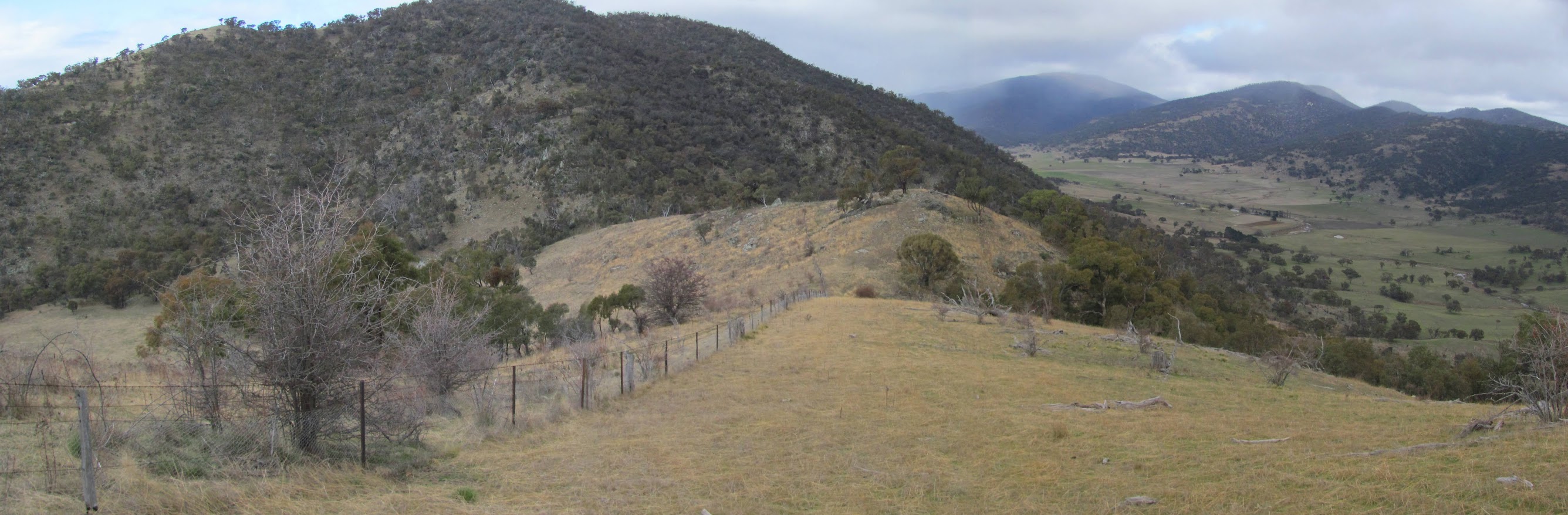
A quick trip back, 6.9km in 1hr 45mins. Plenty of snow on the western border - interesting to be able to see from E to W across the ACT. Soon out of the lightly wooded country onto the lovely rolling section of the lower N Clear Range.
 |
 |
| 2 View from near N27 to the snow-topped western border of the ACT | 3 Lower N Clear Range flanked by Mt Tennent and Rob Roy |
Thanks heaps to Eric G, Garry M, Ian S, Jenny H, Max, S, Philip G, Roger E and Stephen M for excellent border marker hunting and a great day.
Distance: 15.5km Climb: 700m. Time: 7.50am - 2.40pm (call it 7hrs), with 40mins of breaks.
Grading: L/M,X; M(11)
KMZ file for Google Earth/Maps: Border Markers on the N Clear Range
Back to Walks Index
This page last updated 20Aug22