


9-10 August 2010 Folly Point Budawangs
Map:
Getting There
This walk was organised and led by Max S as a 'Tuesday' walk:
Folly Point Budawangs - 1 night pack walk - Monday 9th to Tuesday 10th August - M/M. From Sassafras carpark past Nerriga, along track to Newhaven Gap and then foot track to Folly Point. Return in reverse. About16 km to Folly Point. Propose camping at Folly Point. I am not familiar with the walk but expect a steep pinch or 2, mainly steady up and down thru typical Budawang bush. Expressions of interest welcome with final decision by Saturday before. Approximately 6.00 AM start Map – Endrick Weather to be checked.
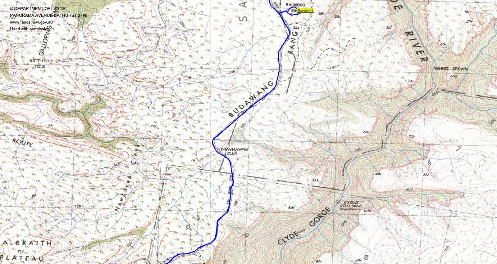
I picked up Max at 6am. Just the 2 of us. Drive via Queanbayean, Bungendore, Tarago, Oallen Ford, Nerriga and Sassafras. Turn down the Endrick River Road at UTM 56H 249943-6112075 (GDA94) and drive around 3km through public-access private land to the car park at the Sassafras entrance to Morton National Park.
Further Information
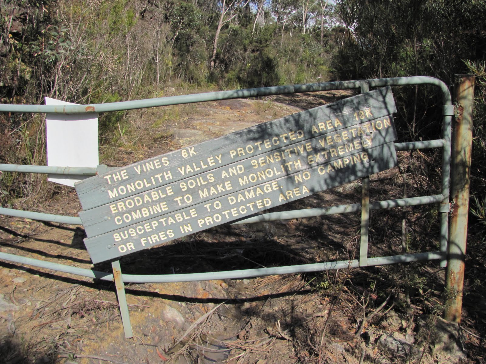
Folks I have changed the start point for this walk to Sassafras carpark following very helpful comments from Eric P who walked to Folly Point, and then some, a few months back (see the CBC report of the trip here, if you have a CBC member's password). This reduces the distance and Eric has confirmed water at the destination. Good space at the camp site I understand is a bit limited so will restrict to 4, a number I can keep track of better anyway! This will give more time to enjoy both the walk and the views, if conditions allow. Eric's comments included:
The "trig" is actually a metal upright stuck into the conglomerate with a metal book container with a book inside. It is not far away from the descent into Watsons Pass. Just down from the "trig" is the water supply - quite obvious - recommend treatment/boiling but we did not - and the campsite is nearby. The track to the lookout is 400-500 metres (maybe 300) before the "trig". There is a dip or saddle between the place where the track to the lookout starts and the "trig". The track to the lookout is to the west just before the saddle. It is imperative you find this to enjoy the views - and allow plenty of time for enjoyment.
We also had a trip report from a 2004 trip by Paul Ellis (Shoalhaven Bushwalkers) here.
Photographs
Access all primary pics here. All thumbnails in the walk report are active - click for a larger picture.
Walk
|
|
|
|
|
| Track overview Folly Point | Track a | Track b | Track c | Track d |
Around 2hrs 15mins drive from Woden, including a 10 minute wait at roadworks and a very slow drive in off the Nerriga Road. Low gear and 4WD was useful at a couple of patches - even more useful coming out in the rain.
Walking by 8.30am. Some signage at the park entrance, down 600m to the camping area, then a 3.4km wander in 45mins along the old road to the Bhundoo Hill turnoff. Views to Jervis Bay and Pt Perpendicular on the way. We circumnavigated the hill, but the scrubby top with no views assumed was not inviting.
Back on the road, a further 4.5km in 55mins took us through Newhaven Gap, past a turn off which we could not find to a Sawmill Ruins site marked on the first edition map, through the gate that one used to be able to drive in to and, a few hundred metres further on, the start of the Folly Point track.
 |
 |
| Walking the Endrick River Road towards Bhundoo Hill | Gate on Endrick River Road that you used to be able to drive in to |
The Folly Point track leaves the Endrick River Road at UTM 56H 249120-6102390 (GDA94) and is marked by 2 cairns on the sloping rock. A wonderful little track/pad of 8.5km which we covered in 3hrs 15mins, taking plenty of time for morning tea and to admire the fabulous views. The track is well marked with small stone cairns (the early ones looked as though someone had applied a boot to many of them, so we rebuilt many of them) and a few tapes in the timbered areas. Only had to stop and search once on the track in (return to the last marked point and search around for the next). We missed the turn off to Mitchell Lookout (if it's there), so no doubt Max will have us back in here at some stage.
 |
 |
 |
| Max at the double cairns marking the turnoff to Folly Point from the Endrick River Road | 1 2.3km along the Folly Point track | View to The Castle, Shrouded Gods Mountain, Mt Cole and others from morning tea |
 |
 |
|
| View to The Castle, Shrouded Gods Mountain and Mt Cole from morning tea | Crossing a feeder to Camping Rock Creek on the Folly Point track |
We didn't quite know what to expect as we neared our destination - the map markings for Folly Point Lookout, Folly Point and Watson Pass are generalised. A bit of faffing around to get ourselves right. The cairns are a bit larger around the destination and guide one from one island of vegetation to the next through a sea of open conglomerate. We initially missed the turn off to Folly Point Lookout, walked through the camp sites a few tens of metres further on to the 'trig' - the visitors book - and the fabulous views above the creek cutting down.
Sucked in the views, then returned to set up tents and get water.
 |
 |
| 2 Folly Point visitors book | Water supply below Folly Point visitors book |
Time to explore! I must say I admire Max's adventurous spirit (even though at times it puts the wind up me as I follow him). The first task was to find Folly Point Lookout (nowhere near where the map has it), based on the hints Eric had provided. So we back-tracked out the way in for around 700m, only taking one false lead, until we found a large and small cairn about 1m apart at UTM 56H 248839-6097028 (GDA94). Pushing through some bushes revealed a cairned route to Folly Point Lookout. It's around 500m out to the edge. There were a number of cairns - I just recorded one a short way in to set the general direction. It's at UTM 56H 248796-6097020 (GDA94).
We spent some time just taking in the view from the 109m cliffs. I recognised some features from previous visits and we found a few more on the Endrick map that Max had. Our time there added so much more to exploring the surrounding area on my digital maps.
 |
 |
 |
| Main Folly Point track cairn at turnoff to Folly Point Lookout UTM 56H 248839-6097028 (GDA94) | Folly Point Lookout track cairn at turnoff from main Folly Point track UTM 56H 248839-6097028 (GDA94) | Sweeping view from Folly Point Lookout |
 |
 |
 |
| 3 Byangee Walls, The Castle, Darri Head and Shrouded Gods Mountain from Folly Point Lookout | Marker cairns behind Folly Point Lookout | Pigeon House over Castle Head and Byangee Walls from Folly Point Lookout |
Sated, we headed another 200m N along the cliff face for views down into Camping Rock Creek above Munnuldi Falls.
 |
 |
| Max overlooks Camping Rock Creek from a little further N of Folly Point Lookout | Flowers near Folly Point Lookout |
Returning to camp, we next set out to find Watson Pass. Missing the cairn just out of sight round the contour from the visitors book (we found it at UTM 56H 248651-6096617 (GDA94) coming back from the Pass), we headed as we could down the creek which runs below the visitors book. This took us to a shear drop which could not be Watson Pass.
Heading back, Max found a cairn and disappeared down from sight. Another cairn or two meant that we were on the Watson Pass route and we descended relatively easily (except for one drop which nearly stopped us, but there was an easy chimney scramble beside it) through the rocks until the route gained the top of the forest. Time beat us, but I'm sure Max will have us back here. Returning to camp along the cairned route, we found the chain and pegs and the cairn (referenced above) next round from the visitors book.
 |
 |
 |
| Views from below the Folly Point camp | Max descends the top of Watsons Pass | Chain and pegs at top of Watsons Pass |
A pleasant evening and camp. My home dehydrated tucker continues to impress (well, at least me), drinks were taken pre- and post-dinner, a mild night.
The rain started at 6.30am. We just walked out, doing the 15.2km back to the camping area around 600m short of the car in 4hrs 10mins.
Wonderful, Max, even the wet walk out.
Distance: 36.5km Climb: 400m. Time: 2 days
Grading: M/M; M(10)
KMZ file for Google Earth/Maps: Folly Point
Back to Walks Index
This page last updated 20Aug22