


19 April 2011 Brindabella weirs - Blue Range, Greens, Uriarra and Marshalls
Map: Cotter Dam 1:25000
Getting There
This walk was organised and led by me as a private Tuesday walk:
Tuesday 19 April - Brindabella weirs and border markers- M/M. Wander around Condor Creek looking for Blue Range and Cpt 97 weirs. From Piccadilly Circus, walk Two Sticks Rd and the border break N to the Curries Rd intersection, looking for border markers. Around 16km and 200m climb. Map: Cotter Dam. Leader: John Evans - jevans@pcug.org.au, (h) 6288 7235. Transport: ~$8 per person.
Further Information
0 Park at Bullock Paddock Rd. Ride to ford before Padovans Crossing. Look for CPt97 weir. Walk to Padovans Crossing (see Above the Cotter, p 33) and ground-truth KHA 761 Padovans Crossing. Return.
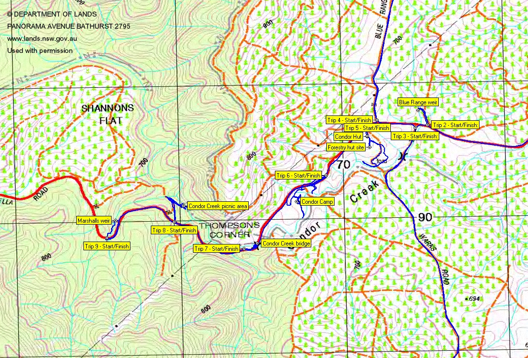
1a Search for Blue Range weir just off the Brindabella Rd up Blue Range Rd, as indicated by John Burns.
1b From the Condor Hut site, ride down Warks Rd to search for Greens weir from Bent J's map. Ground-truth KHA 852 Forestry Hut (Destroyed Jan 2003 bushfire) (this is located at 1st edn map marked building location, around 70m from my visited Condor Hut site).
2a Drive in towards Blue Range Hut. Walk forestry trails to KHA 848 Sherwood historic site and Uriarra weir. Return.
2b Walk to Blue Range Hut - look for vegetable terrace sites (see Above the Cotter, p 107). Search for charcoal pits at first intersection past the hut (see Above the Cotter, p 107). Walk up to Blue Range arboretum KHA 849. Wander fire trails to the W to the seed orchard (is this the nursery mentioned in Above the Cotter, p 34?) site marked on the 1st edn map.
3 Ground-truth KHA 853 Condor Camp (this is located at 1st edn map marked location).
4 KHA 760 Condor Creek (the bridge at Thompsons Corner).
5 KHA 858 Shannons Picnic area (Single artefact located in a gravelled car turning/ parking area at the ACT Forests Shannons Flat picnic area. Site includes remains of an historic hut to be recorded at a later date. Raining heavily when site recorded, adversely affected visibility. Lot...). Condor Creek picnic area also described in Above the Cotter, p 108: "700m after Condor Creek, marked by Water Catchment sign, take the right fork 30m down".
6 Search for Marshalls weir from Bent J's map.
7 Drive to Piccadilly Circus and walk Two Sticks Rd and the border break to the Curries Rd intersection looking for border markers, particularly T50, S50, R50, Q50, P50, 2 Mile, O50, N50 and M50 (not looked for before) and G50, F50 and E50 (which have previously eluded me).
Sunrise 0630. Sunset 1735.
Photographs
You can also access all photographs here.
Walk
| Track maps: thumbnails are active - click for a larger picture | |||||
|
|
|
|
|
|
| Trips overview | Trip 1 | Trips 2, 5-9 | Trip 3 | Trip 4 | Uriarra Crossing trip |
A successful day, with 4 weirs found and 2 major sites visited. However, I was pricked and ripped to shreds by the blackberries.
Trip 1 - Padovans Crossing and a search for Cpt 97 weir
Turning off the Brindabella Rd, a 9.6km return drive along Bullock Paddock Road over Padovans Crossing and onto Vanitys Crossing Road. 0.6km of walks unsuccessfully searching for Cpt 97 weir. Ground-truth KHA 761 Padovans Crossing.
Drive a further 3.5km along Brindabella Rd to park on the N of the road just before Warks Rd leaves to the S.
Trip 2 - Blue Range weir
John Burns had said that Blue Range weir was a hundred metres or so N of the road over the creek which flows under the road just before the Warks Rd intersection. Indeed it was, with initial access via a log-strewn forestry trail. A 0.3km return walk, slowly forcing through the blackberries down by the creek.
Drive a further 0.1km along Brindabella Rd to the Walks Rd turn off.
Trip 3 - Greens weir
A 7.0km return drive along Warks Rd to park at a spot which I thought might be close to Greens weir. From there, a 3.3km walk which took me SE towards the creek line (only to be repelled by the blackberries); back to the car and a return walk S along Warks Rd to the Lees Creek ford; N then E from the car to a rehabilitated forestry track which led up to a knoll to the E of the creek, then down to the loudest gurgling on the creek at Greens weir (woot, woot!); return.
Drive a further 0.3km W along Brindabella Rd to the Blue Range Road intersection.
Trip 4 - Sherwood historic site, Uriarra weir, Blue Range arboretum, charcoal pits, Blue Range Hut
A 4.8km return drive along Blue Range Rd to park the car just past the East West Rd intersection at the gate preventing unauthorised vehicle access to Blue Range Hut. Here I got my bike out and rode 4.6km to the Sherwood historic site. I dropped the bike and walked a total of 1.8km to - N into the Sherwood site, SW up the gentle hill to the seat and followed the old walking track posts till I could see the route was choked with blackberries, back down to the forestry track and ENE to another old walking track post, forced my way through the blackberries across the gurgling creek, headed SSE towards the 1st edn Cotter Dam map-marked weir location. There it was, Uriarra weir, in a currently dry arm of the creek system.
Next rode a 3.8km loop to the NW and S on forestry trails to the Blue Range arboretum. A gate on the SE flank of Two Sticks Hill. N of the arboretum, an eagle soared.
A 0.8km wander from where I dropped my bike at the SE corner of the arboretum back up its E side and a couple of forays into the arboretum site. A metre high fir tree of some sort, definitely not a pinus radiata. Ground-truth KHA 849 Blue Range Arboretum. Then a slow and painful search for the charcoal pits in amongst the blackberries and the oozing creek. The burnt tool shed was evident. Maybe this is KHA 850 Blue Range Internment Camp.
A 0.3km ride S along the road to the Blue Range Hut. A poke about there, then 0.25km further S to the car.
Drive a further 0.2km along the Brindabella Rd and into the signposted Condor Hut ruin.
Trip 5 - Condor Hut, Forestry Hut site
At the S end of the Condor Hut clearing, a well used dirt bike track headed off down through the pine trees and blackberries. I followed it as it curved down to the bank of Condor Creek, turning around when it crossed the creek. A little way back, a disused forestry track headed off on the left and I thought it may go close to the KHA 852 Forestry Hut site. It was slow going, first over the pine logs placed across it, then through the encroaching blackberries. Insult added to injury when it didn't go near the site, but joined onto the cleared dirt bike track.
Back at the Condor Hut clearing, I headed slowly into the pines and blackberries a fraction to the W. The two pieces of galvanised iron and bits of timber I found at the site were hardly worth the scratches. Ground-truth KHA 852 Forestry Hut. 1.0km in total.
Drive 0.5km further SW along the Brindabella Rd, parking at a clear sweep on the left.
Trip 6 - Condor Camp
A 1.7km wander along the road, down to the creek (using the dirt bike track again); back up to the road and back to the car (as I was a bit far from the waypoint for the site and I'd lost a bit of gear); back along the road further, to an old forestry track blocked off with logs; down it to an open area which could be the site of Condor Camp (it's certainly is frog site 110 - I got excited when I saw the star picket and tag), ground-truth KHA 853 Condor Camp; S along the dirt bike track to Condor Creek; then generally N along the dirt bike track till it got too boggy; back to the forestry track and steeply up to Brindabella Rd.
Drive 0.8km to park at the W side of Condor Creek bridge.
Trip 7 - Condor Creek bridge
Walk 0.3km return back along the road to the centre of the bridge, then under it. Ground-truth KHA 760 Condor Creek. The ubiquitous dirt bike track appears to start under the bridge.
Drive 0.5km further W along Brindabella Rd to park on the right at an intersection with a gated forestry track.
Trip 8 - Condor Creek picnic area
A pleasant 0.9km return stroll down the track, turning right at the bottom, to the Condor Creek picnic area. Old table and benches and a fire place. No sign of the hut. Ground-truth KHA 858 Shannons Picnic area.
Drive 0.7km further up Brindabella Rd to park on a corner on the left.
Trip 9 - Marshalls weir
I certainly take my hat off to John Burns' 43 year memory. A couple of times as we drove the Brindabella Rd he said there was a weir down off the road and he was correct. I walked across the road, over the guard rail and bashed down a quite steep little creek. And there was Marshalls weir. A simple matter of climbing steeply and directly up to the road nearby and walking back to the car. 0.4km total.
Uriarra Crossing
I stopped at Uriarra Crossing West and Uriarra Crossing East on the way back. The latter is very pretty and well worth a picnic. Ground-truth KHA 468 Uriarra Crossing West and KHA 469 Uriarra Crossing East.
Distance: 11.1km Climb: 200m, plus 9.0km ride. Time: 7.25am - 2.45pm
Grading: M/M-R,ptX; M(10)
KMZ file for Google Earth/Maps: Blue Range, Greens, Uriarra and Marshalls weirs; Uriarra Crossing
Back to Walks Index
This page last updated 26Ag22