


18 June 2011 Brindabella Sites with Matthew H
Maps: Corin Dam, Tidbinbilla and Cotter Dam 1:25000
Getting There
This walk was organised and led by Matthew H as a private walk.
We were going to have a look around Stockyard Gap and Stockyard arboretum, but were stopped by a fallen tree on the Mt Franklin Rd.
Photographs
You can also access all photographs here.
Walk
| Track maps: thumbnails are active - click for a larger picture | |||
|
|
|
|
| Stop 1 | Stop 2 and Walk 3 | Walks 4 and 5 | Walk 6 |
We left Canberra at 8am in nice sunshine. However, the clouds were hanging over the Brindabella tops and a cold front had gone through during the night. All the roads open at the sign just past Uriarra Station. As we drove round Bendora Hill we ran into a little snow on the road, a couple of deeper drifts further on and were finally stopped by a fallen tree perhaps 2km shy of the Ginini car park. We could have walked in, but the snow cover made site hunting well nigh impossible. With much to-ing and fro-ing we turned the car around and relied on Matthew's fantastic knowledge of the history and sites of the area to fill a great day.
Stop 1 - old Little Ginini ski run
A stop on the Mt Franklin Road. Matthew pointed out a metal pole down below the road to the W and you could see the cleared tree line E and above the road (albeit with plenty of regrowth and saplings). The knoll above the road (SH1693 on the Corin Dam 1:25000 topo map) was originally called Little Ginini). Matthew said that the brave skied down the hill and jumped the road to the slope below!
Stop 2 - 11 Mile marker and blaze; 7½ mile from Piccadilly Circus
We parked the car on the side of the road and wandered across to the 11 Mile marker with its attendant blaze, then a little N to the 7½ mile blaze from Picadilly Circus. Matthew reminded us that the original alignment of the Mt Franklin Road was along Chalet Road. Poor going in the wet on the E side of Bendora Hill caused it to be rerouted onto the dryer W side of Bendora Hill.
Walk 3 - Bendora Arboretum and Wombat Rd loop
We drove to the intersection of Chalet Rd and the Mt Franklin Rd, now out of the snow. We wandered in to Bendora Hut and the arboretum, on the way passing Jim Andersons shower site.
Anderson's Shower
"Mal and Tim had been fishing well above Tops Flats on the Cotter River. Jim cycled to Bendora on the Franklin Road and descended towards Cow Flats higher on the Cotter. He camped on the slope and found the others next morning. On the return trip near Bendora, Jim took a shower in the water falling from a length of bark on the side of the eastern bulge of the Mt Franklin Road [Chalet Road was the original alignment of the Mt Franklin Road]. The bark trough had been planned to direct water from a small creek into the mobile tanks (furphies) used by the road gang. John Cumpston named the creek 'Anderson's Shower'. The name of the area was changed to Bendora much later when a forestry camp was established there." Source: Hiking from early Canberra, Cla Allen, Canberra, 1977, ISBN 0 9596981 0 8, pp 53-54.
A mine of information about the flora, too, Matthew identified Mat Rush (Lomandra longifloria) for me. A look in Bendora Hut, where the stencil on the packing case wall lining was pointed out - addressed from the USA to the Honeysuckle Creek Tracking Station. Then on into the arboretum for a wander about and morning tea. We decided to walk a short loop, down Bendora Break (1st edn map)/Warks Rd (2nd edn map) to the 4-way intersection, right onto Wombat Rd and back to the arboretum via the forestry track (unmarked on 2nd edn but shown on 1st edn Tidbinbilla map). The right person for my plant kick, Matthew pointed out Ribbon Gum (Eucalyptus viminalis), Alpine Ash (Eucalyptus delegatensis) and Old Mans Beard (Clematis aristata) along the way. He even counted about 150 growth rings on a sawn tree fallen across the road. Back at Bendora Hut we had lunch, then walked back to the car.
Walk 4 - Bulls Head picnic area
Next stop was Bulls Head picnic area, the site of the old forestry settlement (read all about it in Matthew's book Rugged Beyond Imagination, National Museum of Australia Press, 2009). We had a look at the Lawson Cypress and plaque, wandered up to the site of the Bulls Head fire tower, then back to a rubbish dump (containing the shell of a 1950s Holden) just down to the W from the picnic area.
Walk 5 - Brindabella Mountain fire tower site
On to Piccadilly Circus, where we walked up the power line service track to Brindabella Mountain to view the site (burnt, fallen tree plus a few bits of tin and wire) of a firetower that was built in a Snow Gum (see page 129 of Rugged...). With a couple of clear patches, nice views to the Goodradigbee, Tidbinbilla Range and Canberra.
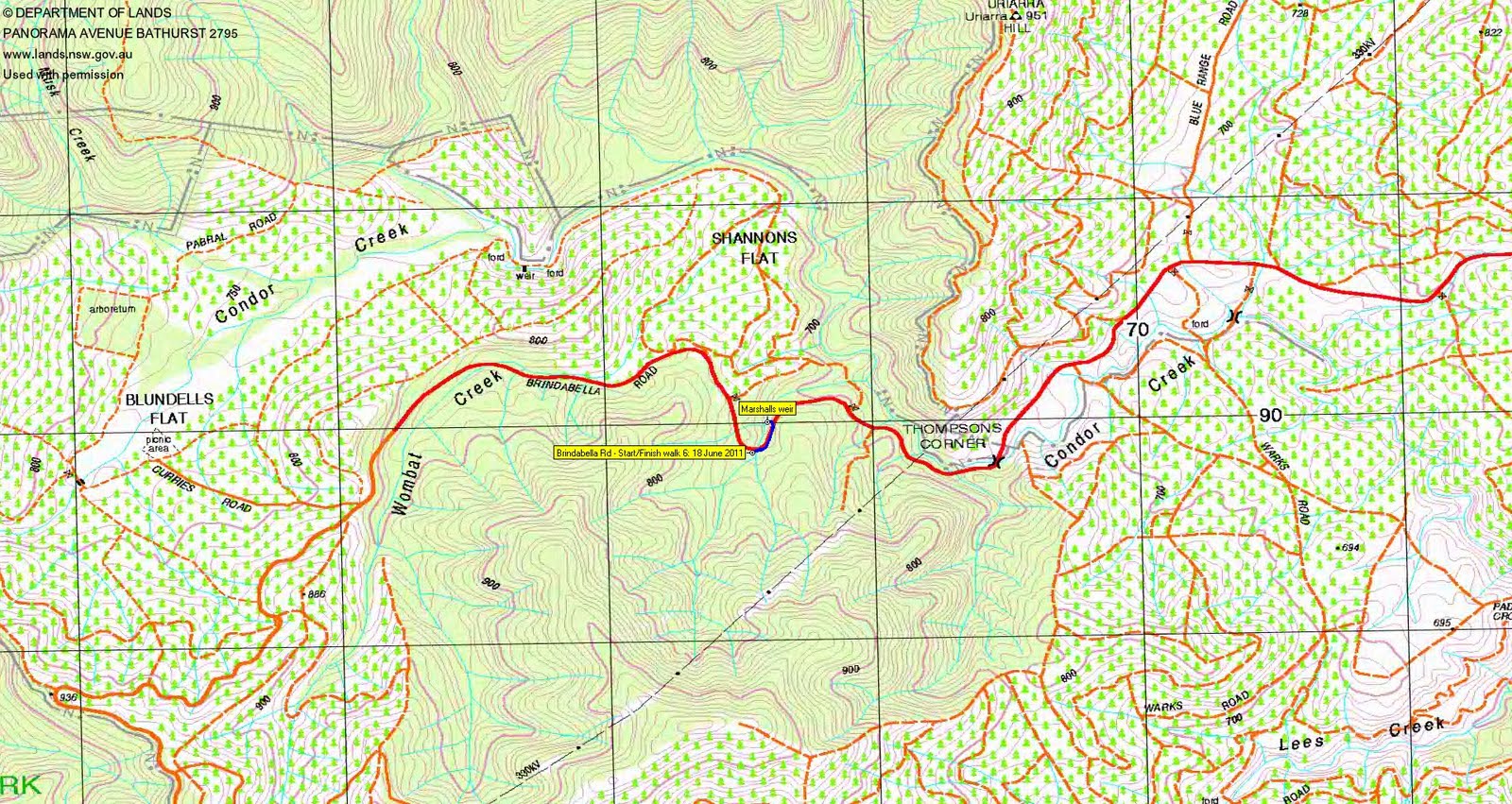
Walk 6 - Marshalls weir
All I could contribute in return was a visit to Marshalls weir after we got back onto the tarred Brindabella Road. Nice hand-packed rock wall over the edge of the guard rail where we descended to the weir. Maiden hair fern (Adiantum spp) growing by the weir - I can manage to kill it at home.
A wonderful day after we were initially thwarted. Huge thanks Matthew, and to Mike B and Rob M.
Distance: 12.4km Climb: 400m. Time: 10.15am - 2.35pm (4hrs 20mins), with plenty of driving in between and stops.
Grading: M/E; M(8)
KMZ file for Google Earth/Maps: Brindabella Sites with Matthew H
Back to Walks Index
This page last updated 26Aug22