
7 August 2012 More Border Markers on the Clear Range from Caloola
|
| View N along the Clear Range from B30 near Mt Yarara |
Map: Michelago 1:25000
Getting There
This walk was organised and led by me as an irregular CBC Tuesday walk:
Tuesday 7 August - More Border Markers on the Clear Range from Caloola - L/R,W,ptX. Naas Valley Fire Trail from Caloola Farm, crossing the Naas River 7 times. Climb The Forest Trail to the Mt Clear Fire Trail including off-track to cut the southern loop. Hunt border markers north through Mt Yarara to east of Caloola. 450m down the side of the Clear Range back to the start. Around 25km and 700m climb. I don't wish to return a third time, so this trip is for fast walkers only. Map: Michelago. Leader: John Evans - john@johnevans.id.au, 0417 436 877. Transport: ~$10 per person.
3 of us drove via the Naas Rd to Caloola Farm. We were greeted by John, the Caloola Farm Manager, and signed in on the board.
Further Information
Similar entry and an extension of hunting from 14 Feb 12. Checked with Manager John and all ok to come out.
On 14 Feb 12 we did 27km in 8hrs 30mins, from 7.25am - 3.55pm and visited 26 BMs. For 7 Aug 12, sunrise is 6.53am, sunset is 5.26pm and civil sunset is 5.52pm.
Photographs
You can access all photographs here.
Walk
| Track maps: thumbnails are active - click for a larger picture | |||
 |
 |
 |
 |
| Track overview | Track 1 | Track 2 | Track 3 |
A hugely successful day, a fast and cohesive party, beautiful blue-sky day with no breeze and every objective achieved! Most satisfying and I don't have to go back to this area.
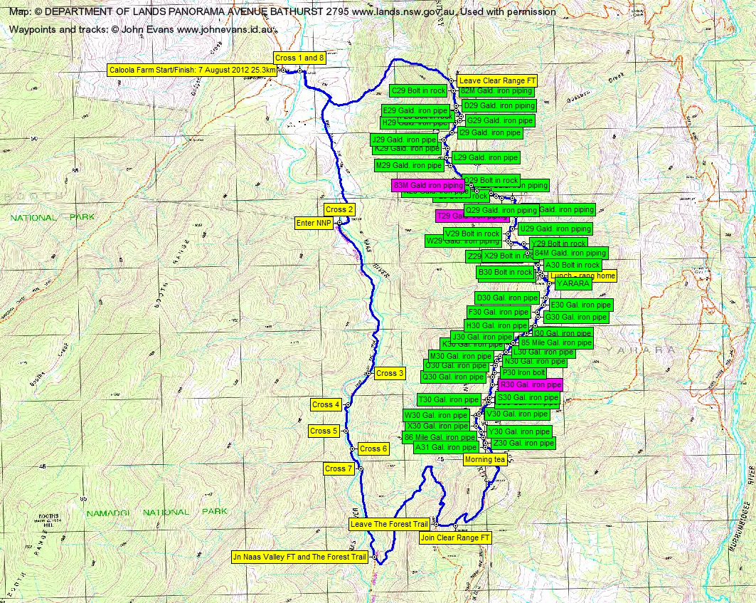
We visited 57 border marker locations from A31 in the South to 82 Mile/C29 in the North. 11 had been seen before (A31, Yarara, C30, B30, A30, Z29, 84 Mile, Y29, S29, 82 Mile, C29). Of the 46 new locations visited, we found 41 border markers and 2 mile markers. 2 border markers and 1 mile marker could not be located at their locations - in the middle or at the side of the Mt Clear FT. We found Z30, 86 Mile, Y30, X30, W30, V30, U30, T30, S30. The location of R30 was in the middle of the Mt Clear FT, so not there. We found Q30, P30, O30, N30, M30, L30, K30, 85 Mile, J30, I30, H30, G30, F30, E30, D30. We found X29, W29, V29, U29. The location of T29 was just on the side of the Mt Clear FT, so not there. We found R29, Q29, P29, O29, N29. The location of 83 Mile was in the middle of the Mt Clear FT, so not there. We found M29, L29, K29, J29, I29, H29, G29, F29, E29, D29.
One of the party had a swim at the third Naas River Crossing and it was frosty cold till the sun finally hit us some time after that. The crossings seem to get deeper and deeper (even though we were heading upstream), some of them shin deep.
We left the Naas Valley Fire Trail and turned up The Forest Trail. After the zig of it to the N and a half zag to the S, we were ready to head into the bush. 11.7km in 2hrs 25mins to here - I was most grateful for the boys' pace. Up 100 vertical metres to join the Mt Clear Fire Trail. It was very overgrown where we joined it and for a kilometre or so to the N. Morning tea at A31, the N most border marker reached on 14 Feb 12. It was 13.9km in 3hrs 10mins from Caloola to this point. Not too bad at all.
We then began a most successful hunt along the generally open timbered ridge top, crisscrossing the Mt Clear Fire Trail a couple of times. We found Z30, 86 Mile, Y30, X30, W30, V30, U30, T30 and S30. R30 has gone forever, its location in the middle of the Mt Clear Fire Trail. We found Q30, P30, O30 (I shut down the iPhone before the photo had been fully stored), N30, M30, L30, K30, and 85 Mile.
This brought us to the pleasant open approach to Mt Yarara. We found J30, I30 (with a little animal shelter visible a few tens of metres to the E over the border fence), H30, G30, F30, E30 and D30.
Yarara and N to the next saddle we'd visited previously. But we took the opportunity to revisit the markers - Yarara, C30 (where we had lunch), B30, A30, Z29, 84 Mile and Y29.
Continuing N, we found X29, W29, V29 and U29. T29 has gone forever, its location was just on the side of the Mt Clear FT. We found S29, R29, Q29, P29, O29 and B29. 83 Mile has gone forever, its location in the middle of the Mt Clear Fire Trail.
The remaining border markers involved a wander through the scrub parallel with the Mt Clear Fire trail. We found M29, L29, K29, J29, I29, H29, G29, F29, E29 and D29. We ended up back on the fire trail at the co-located 82 Mile and C29, the S most markers reached on 10 Apr 12.
To leave the range, we wandered down the next spur system to the N, which included a nice open spur running down to the SW that I'd seen on Google Earth. It was even hot in the open under the westering sun.
One last splash across the Naas River and we were back at the car at Caloola. We signed out off the Bushwalking Board.
A quick beer at the Tharwa General Store on the way home.
Thanks for a most successful day to Eric G and Stewart J.
Distance: 25.3km Climb: 950m. Time: 7.30am - 3.50pm (8hrs 20mins), including 35mins of stops.
Grading: L/R,W,ptX; H(14)
KMZ file for Google Earth/Maps: More Border Markers on the Clear Range from Caloola
Back to Walks Index
This page last updated 1Sep22