
18 August 2012 Canberra Centenary Trail: Sections 7 and 8 - Tuggeranong to Parliament House via S Canberra ridges
|
| View to Woden from just N of Red Hill saddle |
Maps: Tuggeranong and Canberra 1:25000
Getting There
This walk was organised and led by me as a private walk:
Saturday 18 August - Canberra Centenary Trail: Sections 7 and 8 - Tuggeranong to Parliament House via S Canberra ridges- L/E,ptX. Follow the proposed route of the CCT beside Tuggeranong Creek, through MacArthur onto the Isaacs Ridge. Then via Red Hill and down Melbourne Avenue to Parliament House. Around 30km and 300m climb. Maps: Tuggeranong and Canberra. Leader: John Evans - john@johnevans.id.au, 0417 436 877. Transport: ~$10 per person, car shuttle required.
2 of us met at Tuggeranong.
Further Information
For 18 Aug 12, civil sunrise is 6.15am, sunrise is 6.41am, sunset is 5.34pm, civil sunset is 6.00pm.
2 had booked, those 2 pulled out and Alan joined in.
Photographs
You can access all photographs here.
Walk
| Track maps: thumbnails are active - click for a larger picture | |||
 |
 |
 |
 |
| Track overview | Track 1 | Track 2 | Track 3 |
 |
 |
 |
|
| Track 4 | Track 5 | Track 6 | |
Showers forecast for the day, but it remained dry. Plenty of snow to be seen on the Tidbinbilla Range and the hills around Mt Tennant. The breeze was cool up on the ridges, but it seemed to be blowing from the N.
Got going at 7.15am, as Alan was waiting in one part of the car park and me another. I need to be more specific.
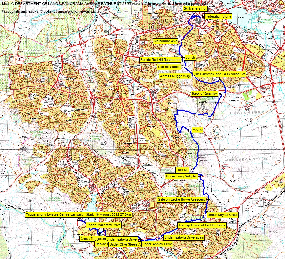
The proposed alignment of the Canberra Centenary Trail took us along Anketell St, past the front of the Hyperdome. Lots of cafes and toilets here, as long as it is in business hours. I think McDonalds is nearby, so there's another location. Left along Reed St North and past the Tuggeranong Arts Centre and onto the edge of Lake Tuggeranong. Crossed Tuggeranong Creek via the Tuggeranong Weir along a bike path, then under Drakeford Drive.
A rather uninteresting section followed, up the Tuggeranong Creek concrete channel, paralleling Isabella Drive and across the S side of Monash and Gowrie. A bit more pleasant as we passed through the Fadden Pines area. I took the wrong path for a bit and we had to double back and the track shows that we also visited the Fadden Pines public toilets. NE past the huge tennis centre, under Coyne St and up the paths through the middle of MacArthur.
Through the gate on the N side of Jackie Howe Crescent, we deviated a bit from the proposed (initial) alignment of the Trail. We followed the management trail that took us into the Wanniassa Hills Nature Reserve, then more directly to the Long Gully Rd underpass.
Back on the proposed alignment, touching Long Gully Rd at a car accident memorial. Then NE to the Isaacs Ridge and N along it. Nice views in the chilly breeze. Another deviation as we continued along the ridge and a bit steeply down.
Through the Isaacs Ridge NR, passed the YA90 trig, then NW and S and N along the E side of the N part of Isaacs.
We stopped for morning tea at the SE corner of O'Malley, within a couple of hundred metres of Alan's home.
More deviation from us on the next leg, following a trail E across the N boundary of the Isaacs Ridge NR and avoiding the riding school leases, then up to the old Mugga Quarry area. This could be a useful route, as it ends up on old sealed roads and goes through the (recent) historical area of the old quarry offices, weigh-bridge and Aloevera plants. Rejoined the proposed alignment N of the reservoir, down along the old road past Murray's Buses on the right and along the side of Mugga Lane for a bit. Past the dog pound, then via obviously public footpads/paths along the W and N boundary of Quamby.
To the traffic lights on Hindmarsh Drive - felt a little weird entering suburbia in bushwalking kit, but it was still very cool in the wind. Dalrymple St, left into La Perouse and past the Red Hill shops. A coffee could be had here in business hours, plus one of the few points with bus access. Across Mugga Way to the entrance to Red Hill NR E of Davidson trig.
NW up to the Red Hill saddle, then N up and along the track to the Red Hill Restaurant. Fine dining here in opening hours, if you're into that. Public toilets nearby. We walked N to the end of the parking area by the entry/exit road and had lunch.
The only 'bushwalk' for the day, as I left the road and paralleled it to the E to get out of the wind. Some steep contouring. Took a short-cut down a recognised (because it had some nice signage beside it) footpad to rejoin the alignment, to rejoin the proposed alignment, cross Mugga Way and get on to Melbourne Avenue.
Down Melbourne Avenue, across State Circle back down some grass to cross under Adelaide Avenue via State Circle's footpath. Then across the circular flyoff from Adelaide Avenue to State Circle and around the NW quadrant between State Circle and Capital Circle. A delightful strip of remnant woodland! Through it to the Scriveners Hut barbeque area.
From here, up what I used to think was a bike path, but it leads to the special tracks that run through the well maintained and watered bushland surrounding Parliament House. A lovely approach. TO the front of Parliament House, a quick circle of the Federation Stone, then down one of the two outside staircases to wait in the underground car park for our lift.
Thanks for your company Alan V. And a huge thanks to Sue for driving me back to Tuggers to my car.
Distance: 27.8km Climb: 450m. Time: 7.15am - 1.15pm (6hrs), with 25mins of stops.
Grading: L/E,ptX; M(10)
KMZ file for Google Earth/Maps: CCT Tuggeranong to Parliament House
Back to Walks Index
This page last updated 1Sep22