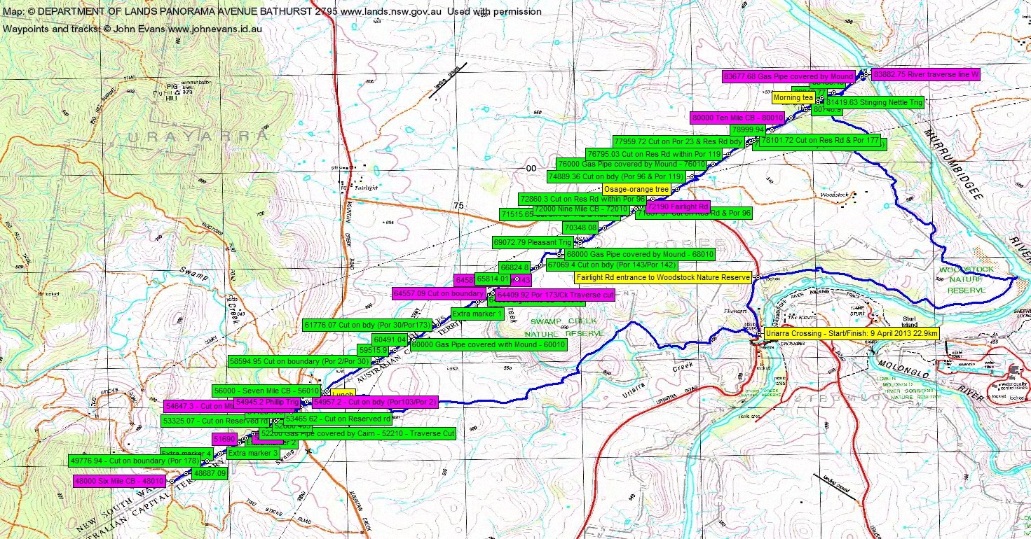
9 April 2013 Border Markers from Mountain Creek Rd to the Murrumbidgee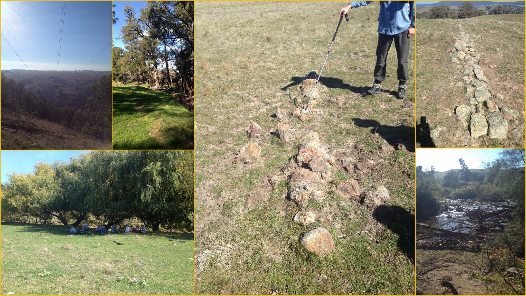 Markers, powerlines, Swamp Creek NR, lunch, lowest point in the ACT Maps: Umburra and Cotter Dam 1:25000 Walk Description This walk was organised and led by me as an irregular CBC Tuesday walk: Tuesday 9 April: Border Markers from Mountain Creek Rd to the Murrumbidgee - L/M,X. Park at Uriarra Crossing and walk the Murrumbidgee River downstream through the Woodstock Nature Reserve to the border. Follow the border up through Stinging Nettle Hill out of the NR, across 'Woodstock' (permission has been obtained from the land holder) to Fairlight Rd. Continue across Pleasant Hill through 'Brookvale' (permission has been obtained from the land holder) to Mountain Creek Rd. Perhaps continue along the border to Two Sticks Rd. Return NE to the Swamp Creek Nature Reserve and back to Uriarra Crossing. Around 20km and 400m climb. Maps: Umburra and Cotter Dam. Limit: 8. Leader: John Evans - john@johnevans.id.au, 0417 436 877. Transport: ~$6 per person. 9 of us drove from Canberra to Uriarra Crossing. Further Information OK from owners of 'Brookvale' and 'Woodstock' on 20 Jan. Latter wants cooler weather to lessen fire risk. Ring both closer to the date to tell them when. Rang Judy B of 'Brookvale' 3/4/13 - OK. She told me Tony G of 'Uriarra' was agisting stock between Mountain Creek Rd and Two Sticks Rd. Rang him 3/4/13 - OK. Spoke with Michael R of 'Woodstock' 4/4/13 - OK. The straight line of the ACT border runs at 42°M in a NE direction from Mt Coree to One Tree Hill and 222°M in a SW direction. Could be a wet few steps - we have to cross Swamp Creek several times. Photographs Click here to access all walk photographs.Track Maps Track maps: thumbnails are active - click for a larger picture
Google Earth Track Notes A productive day, a little boring walking the grazing land, but also good as I'd never been in this area before. We visited 53 border and mile markers and found 40 of them. All the markers on the straight line of the ACT border are named with the distance in links from Mt Coree. We found 83185.43, 82212.77, 81419.63 Stinging Nettle Trig, 80746.9, 78999.94, 78101.72, 77959.72, 77706.9, 76795.03, 76000 Gas Pipe covered by Mound/76010, 74889.36, 72860.3, Extra marker on W side of Fairlight Rd, 72000 Nine Mile CB/72010, 71657.97, 71515.65, 70348.08, 69072.79 Pleasant Trig, 68000 Gas Pipe covered by Mound/68010, 67069.4, 66824.8, 65814.01, 64000 Eight Mile CB/64010, Extra marker 1, 61776.07, 60491.04, 60000 Gas Pipe covered by Mound/60010, 59515.9, 58594.95, 56000 Seven Mile CB/56010, 54129.775, 53465.62, 53325.07, 52880.405, 52200 Gas Pipe covered by Cairn/52210, Extra marker 2, Extra marker 3, Extra marker 4, 49776.94, 48687.09. We could not find 83882.75 River traverse line W (washed away), 83677.68 Gas Pipe covered by Mound/8368.68 (in a huge blackberry wall), 80000 Ten Mile CB/80010, 72190 Fairlight Rd, 64587.49, 64557.09, 64409..92, 54957.2, 54945.2, 54647.3 - Cut on Mtn Ck Rd N side, 51838.8, 51690, 48000 Six Mile CB/48010. We parked at the picnic ground on Fairlight Rd, just over Uriarra Crossing, then walked up the road to the entrance to the Woodstock Nature Reserve. Followed the track E to the point of the bend in the Murrumbidgee River. Early morning views across to Camp Sturt and up to Shepherds Lookout. The water quality control centre dominates the area. It looked impossible going through the blackberries by the edge of the river, so we climbed away into more open going along the W edge of the Woodstock Nature Reserve. A few ups and downs. Under the power lines and so to a spur near the border that took us down to the lowest point in the ACT (SH429) where the border crosses the Murrumbidgee River (and thus where the river leaves the ACT). Much faffing around to get through the wall of blackberries guarding the river. No 83882.75 River traverse line W, as it was in the overflow area of the river and would have been washed away. Back to the river side of the blackberry wall and 83677.68 Gas Pipe covered by Mound/8368.68 was still 12m away, so we did not see it. We puffed back up the spur, finding 83185.43 and 82212.77. There was handy shade and we could see those of the party who didn't go down to the river, so we stopped for morning tea. Away again and we wandered up to the little mini-trig of Stinging Nettle Hill. Not a stinging nettle in sight. We found 81419.63 Stinging Nettle Trig, a nice long lockspit (straight of course), a little further on from the quadruped trig. Then 80746.9. No 80000 Ten Mile CB/80010 at the location. A good string of finds of 78999.94, 78101.72, 77959.72, 77706.9, 76795.03, 76000 Gas Pipe covered by Mound/76010 and 74889.36 although the markers were pretty insignificant. An osage-orange tree. Up the rise to Fairlight Rd, we found 72860.3 but not 72190 Fairlight Rd (there was a modern red post there). Just over the fence on the South side of Fairlight Rd we found an extra new survey peg. The next three finds were insignificant small cairns - 72000 Nine Mile CB/72010, 71657.97 and 71515.65. On the open approach to Pleasant Hill, we found 70348.08, a nice long lockspit. Pleasant Hill was quite pleasant and we found 69072.79 Pleasant Trig just off the high point. Between Pleasant Hill and Swamp Creek we found 68000 Gas Pipe covered by Mound/68010, 67069.4, 66824.8 and 65814.01. But down around the creek and in the blackberries, we could not find 64587.49, 64557.09 or 64409.92. On the leg to near 'Brookvale' we found 64000 Eight Mile CB/64010, Extra marker 1, 61776.07, 60491.04, 60000 Gas Pipe covered by Mound/60010, 59515.9, 58594.95 and 56000 Seven Mile CB/56010. Several in the open paddocks were marked with tall star pickets. Approaching the farm buildings we were greeted by four horses in the paddock. Swamp Creek below the buildings had lovely green grass and shady willows, so we had lunch there. Setting off after lunch three very friendly kelpies came over from the sheep yards and we waved to a couple of men. No sign of 54957.2, 54945.2 or 54647.3 - Cut on Mtn Ck Rd N side around the buildings. After crossing Mountain Creek Rd we had a good run, finding 54129.775, 53465.62, 53325.07, 52880.405 and 52200 Gas Pipe covered by Cairn/52210. No 51838.8 or 51690. Then we found Extra marker 2, Extra marker 3, Extra marker 4, 49776.94 and 48687.09. A bit sad at the final marker 48000 Six Mile CB/48010. I have a photo of it, taken 13 Mar 12. It's now gone with all the earthworks disturbance at the location. Now 1.30pm and we were able to turn for home. Quite warm walking with no shade. A controlled burn on a nearby wooded hill. We headed back to our lunch spot, taking a vehicle track for some of the SW side of Mountain Creek Rd instead of the straight line. We then headed generally E-ish back into the Swamp Creek Nature Reserve. A rare, lovely green patch by the creek between the 600+m and 500+m knolls. But we soon had to climb high above the creek to get around huge infestations of blackberries. With hindsight, it would have been better to take the S side of Uriarra Creek back to the crossing. We continued to dodge blackberries on the N side of Uriarra Creek. The last insult and injury was the last descent to the cars - the blackberries ripped at us right down to the edge of the road opposite the cars. The walk turned out to be a little harder than I thought it would be - a little longer, more climbs, with a few patches of scrub and lots of infernal blackberries. We probably crossed as many fences via gate, over and under, as we did find border markers! Summary Distance: 22.9km Climb: 800m. Time: 7.30am - 3.30pm (8hrs), with 35mins of breaks. Walk Participants 9 walkers - Cynthia C, Roger E, Meredith H, Maggie K, Richard M, Aman S, Ros T, Ian W, me. Back to Walks Index This page last updated 2Sep22 |