24 August 2013 Apollo Rocks
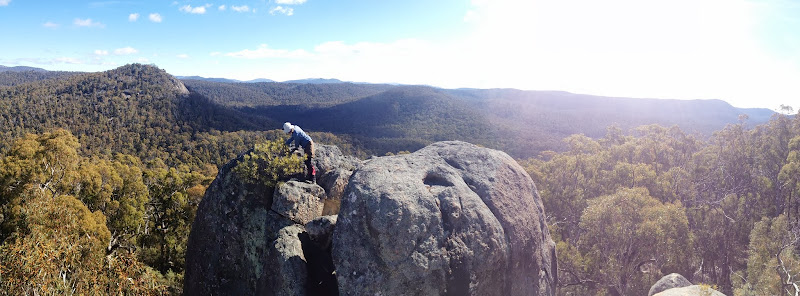 Linda in her element on 'Spinnaker View Rock' Map: Corin Dam 1:25000 Walk Description This walk was organised and led by Linda G as a CBC walk: Saturday 24 August: Apollo Rocks - M/R,ptX. From the Apollo Road at 809E 609N, south, finding a way straight up for 350 metres through scrub and granite bluffs to the outcrop at 809E, 603N. This outcrop has a route inside it that allows access to the very top, with great views. Then SW along the ridge and down to the tracking station site. Thanks to Rob H for introducing me to this ridge (by a far more sensible route). Leader: Linda G. Map: Corin Dam. Transport: $36 per car. Limit: 8. 6 of us drove from Canberra and parked at a convenient spot on the side of Apollo Rd. Photographs Click here to access all walk photographs.Track Map Track map: thumbnail is active - click for a larger picture
Video Google Earth Track Notes Linda's objective on this short walk (but certainly not a ramble!) was to choose the most difficult route with the maximum amount of scrambling. It was challenging in places. We parked on the side of Apollo Rd and were greeted by two wedge-tailed eagles sitting in a tree on the opposite side of the road. It was a beautifully mild, late Winter's morning. We wandered back down the road to a suitable take-off point and began the 330m ascent to the top of the ridge, scrambling up and passing by some great granite formations. You'll see photos of squeezes, big tors and rocks just waiting to be named. There were huge views across the road to SH1396 and Deadmans Hill and, from further up, to the snow-capped Brindabella Range. We took morning tea for 15 or so minutes and arrived at our objective, Apollo Rocks, at 11.40am. I seem to have exorcised a few demons lately. My first disgrace coming off Mt Yarara on 18 Feb 06 has been expunged several times and I recently made up for my poor night time navigation on the Navigation Course on 13 May 04. Today presented me with the opportunity to climb up inside Apollo Rocks, which I'd wimped out of on 29 Jul 08. It was an interesting scramble, picture windows of rock in places. Towards the top, the best method was to lie on your back to get the best hand-holds to wriggle up through a slot to the top. Fabulous views all round and we spent some time up there. At last we had to descend, helping each other to pass packs down and guide feet to secure places. As the track map shows, we then walked/scrambled down and up the knolls along the ridge to the SW. Lunch with a view was included. A massive tor christened 'Spinnaker View Rock' provided exactly that on our descent to the open saddle between the ridge and The Spinnaker. Down in the open, Barrie found 'Sun Dial Rock' for us. A couple of us explored a little way to the SSE; Barrie suggested a nice walk down that way. We exited along the footpad (detailed here) to the fire trail coming from the tanks and followed it down to the creek crossing. Linda, not content with a simple return via Honeysuckle Creek camping ground, turned us down the creek. Good on her because, as a last little surprise for the day, we came across a weir and pumps which used to serve the Honeysuckle Creek Tracking Station. Just near it (whoops, I misplaced the 'Start of Track' waypoint on the track map) was an old road leading towards the Tracking Station site and another old benched track which headed NE of it. We followed that and, as it bent right away to the W, just wandered down 40m of bush to come out at the Booroomba Rocks turn off. 500m had us back at the cars. A cameo of a walk with some scrambling. Summary Distance: 8.4km Climb: 410m. Time: 8.40am - 3.10pm (6hrs 30 mins), with 1hr of breaks. Walk Participants 6 walkers - Peter C, Linda G (leader), Jack J, Meg McK, Barrie R, me. Back to Walks Index This page last updated 3Sep22 |
