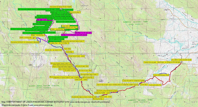
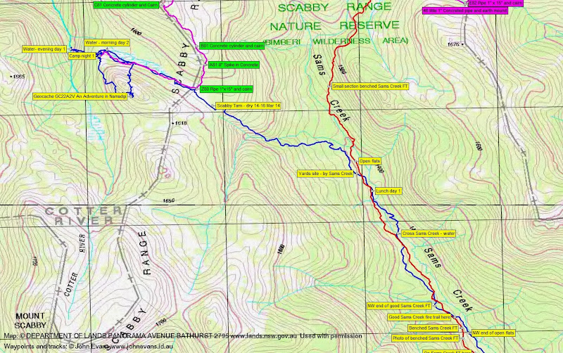
14-16 March 2014 3 days Border Marker Hunting on the Scabby Range Mt Kelly, Coronet Peak, Rotten Swamp, Mt Namadgi and Mt Burbidge from Z81 on the granite slabs of 1733m feature Maps: Rendezvous Creek and Yaouk 1:25000 Walk Description This walk was organised and led by me as a short-notice CBC walk: Friday-Sunday 14-16 March 2014: 3 days Border Marker Hunting on the Scabby Range - L/R,ptX. Hunt for border markers on the A-shape of the ACT border SW and SE of Mt Kelly. This is beautiful country, but rugged. Insert via the Gudgenby saddle and Sams Creek fire trail to the Scabby Tarn. Walk the border up through Mt Kelly and down through The Fortress and along the west side of Mt Gudgenby. Around 38km and 1600m climb. Maps: Rendezvous Creek and Yaouk. Limit: 4 strong walkers. Leader: John Evans - john@johnevans.id.au, 0417 436 877. Transport: ~$15 per person. Further details at www.johnevans.id.au. 3 of us drove from Canberra and parked at the Yankee Hat car park. Further Information Leaving the best till last, this will be nearly the last of the ACT border I have to walk. Day 1 - from Yankee Hat car park via the usual FTs and open lead to the start of the Gudgenby Saddle footpad; footpad to Gudgenby saddle; ctu down to join Sams Creek FT (on 13-14 Jul 13 the 10km to the Sams Creek crossing took 3 hours); Sams Creek FT alignment to GR 69892-42772 (MGA94); 273°M to Scabby Tarn to camp. 15.5km. If time available, look for geocache Geocache 'GC22A2V An Adventure in Namadgi' about 600m W of the camp. Other option is to continue up the border, but we'd have to carry water.
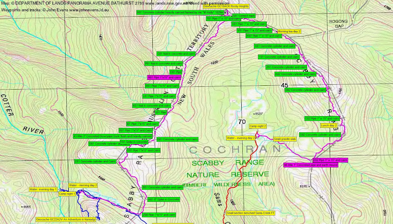
Markers to hunt: Day 1 - Geocache Geocache 'GC22A2V An Adventure in Namadgi' = 1 Day 2 - A81, B81, C81, D81, E81, F81, G81, 43 Mile, H81, I81, J81, K81, L81, M81, N81, O81, P81, Q81, Geocache 'GC18ACK Rocky Heights',T81, U81, W81, X81, Y81, Z81, A82, B82, C82, D82, E82, 46 Mile = 31 Day 3 - F82, G82, H82, I82, J82, K82, L82, 47 Mile, M82, N82, O82, P82, answer questions for 'GC1JWEX Yankee Doodle Dandy' = 13. Here's my gear list.
Photographs Click here to access all walk photographs,or sit back and watch the pretty pictures (slideshow not available via smart phone access). Track Maps Track maps: thumbnails are active - click for a larger picture
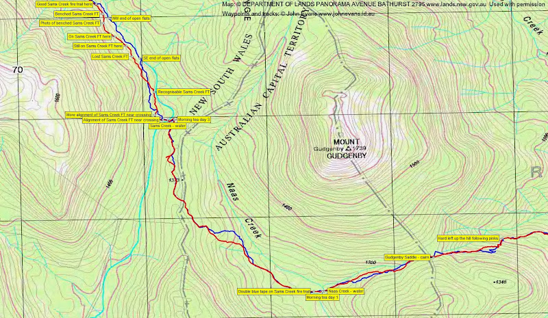
Videos Google Earth Click here to download the walk's .kmz file for display in Google Earth on your PC. (Haven't got Google Earth? Get it for mobile or Get it for PC/Mac/Linux) Track Notes Day 1 -Yankee Hat car park via Sams Creek fire trail alignment and Scabby Tarn to Cotter River Friday was a blue-sky day, although the clouds came over in the evening. My companions, Ian and Stephen, proved immediately useful, as I lost the track and my sun glasses a couple of times during the insert. A drink break at Gudgenby saddle and morning tea at Naas Creek. We picked up a bit of water at the first crossing of Sams Creek near the black sallee camp site. Made the 10.8km to here in 3hrs 15mins, so only a bit slower than 13-14 Jul 13. Not good route finding on my behalf as we headed up the Sams Creek Fire Trail alignment. Coming out of the creek crossing I started too low, then went too high (a bit of pea regrowth to push through), then too low again down along the creek flats. I had the waypoint 'Good Sams Creek fire trail here', so went up to it. Crossed then re-crossed Sams Creek and stopped for lunch at 12.30pm. This leg up Sams Creek 3.1km in 1hr 15mins. After lunch we continued up across the open yards site, then turned NW and climbed up to the Scabby Tarn. This leg 1.9km in 55mins, so not too bad. However ... Scabby Tarn was dry! So plan B was to wander down the drainage line from the tarn towards the Cotter River, looking for water. On the way we went to look for the Z80 border marker, but couldn't find it. No water (so I thought), so we propped near the steep drop to the Cotter, dropped our gear and went down to the mighty - just a trickle here - Cotter River. Filled up and lugged the water back up. All this was 2km in 1hr 15mins. It was not possible to return to the Scabby Tarn/border area, as we didn't have enough water carrying containers for tea plus the dry next day (an empty 4l wine cask bladder weighs next to nothing and is great for camp water), so we made the best of a poor site to camp. Anyway there were other plans ... Dumping most of our gear and setting up tents, we headed S and E around the flanks of the nearby knoll and up to geocache 'GC22A2V An Adventure in Namadgi'. Not the best approach (as we found later) - very scrubby and rocky. However, geocachers and friend cannot be daunted and BorderTrekker made the find and logged us in. A remote cache, with the last visit on 21 Mar 10. Magnificent views all round! Videos 1 and 2 are worth a thousand words. From our vantage point there was an obvious and (relatively) easy exit down to the N. And the glint of water in the Scabby Tarn drain near our camp site. So down we went and over to check the water source for use on the way out the next morning. This little jaunt and taking in the views 1.7km in 2hrs. There are several reasons why the Walks Secretary gives me approval to run a walk with 3 in the party as a CBC walk, when normally the minimum party size for safety is 4. These include:
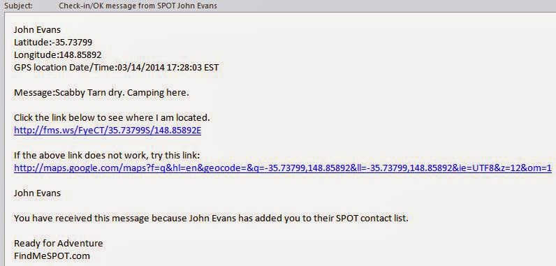
One gadget is a SPOT Communicator which, bluetooth-paired with a smart phone, allows one-way field-composed short messages. (It has a stand-alone SOS button as well). These messages go to 2 bushwalking mates and non walking wife who know what we're up to. An example of what's received by email (and similar to SMS) is:
Cooked tea on gas and, although we were in the ACT without a fire permit (we would have been ok in NSW at the Scabby Tarn), lit a small fire for a bit of cheer and conversation. A mild, starry night with a full moon. Day 2 - Cotter River via Mt Kelly to top of Sams Creek Broke camp and away by 7.45am. Picked up water at the spot identified yesterday afternoon and walked up the drainage line. Found Z80. 0.9km in 25mins. Pleasant going up the Scabby Range in a NE direction towards Mt Kelly. A couple of ups and downs. The saddle near J81 was dry. Found A81, B81, C81, D81, E81, F81, G81 (a bit knocked around when we arrived, but we repaired it), 43 Mile marker, H81, I81, J81, K81, L81 and M81. A fine collection of concrete cylinders (in food tins?), spikes, 3" concreted downpipe and nails in the lockspits at the border corners. No N81. Some great views forward to Mt Kelly and across the top of Sams Creek to the Scabby Range running down SE from Kelly. Found O81. Surprised to get (Telstra) phone reception here. Rang friends who were cycling this morning and told them I wouldn't be there. Found P81. Rang Tim the Yowie Man's producer at ABC 666 to see if he wanted to talk on air. She said they'd call back and I missed TYM's SMS, so no. Found Q81. From Z80 to Q81 was 3.3km in 1hr 50mins. Our ascent of Mt Kelly began, with fine views opening up. Lovely drain from the saddle between Kelly and the bump at the start of the Kelly Spur. Huge views across the top of Sams Creek to the 1700+m feature and down to the Fortress along the Scabby Range running SE from Kelly, the area we were to cover this afternoon and Sunday. At the top at 10.30am, from Q1 to Kelly was 0.8km in 30mins. BorderTrekker and I had a hunt for geocache ' GC18ACK Rocky Heights' and once again my companion came up with the goods. Rang home. We had a good dose of the scenery and I took a bit away in video and photos. Absolutely stunning! We continued down along the border, finding S81, T81, U81 and V81. A rough descent and definitely not the recommended route (the usual descent from Kelly to Kelly saddle descends the granite slabs near the top and swings a bit to the E then to the saddle). Ian surprised a snake - or vice versa. Morning tea in Kelly Saddle. The descent was 0.8km in 40mins. New country for me after morning tea. I've been in this area a bit and always hankered to have a look up around the 1700+m feature (SH1733 marked on the 1st edn Rendezvous Creek 1:25000 topo map). The ascent was a bit scrubby. Found W81, X81 (a 1" gal pipe) and Y81. We broke out of the scrub onto the magnificent granite slabs. Huge views to the heart of the Namadgi - Kelly, Namadgi and Burbidge with Rotten Swamp. Found Z81, A82 and B82 which are atop huge granite slabs and command some of the best views of the Bimberi Wilderness Area. There may be a geocache come on line at A82, so that's another reason to visit up here :-). C82 was pretty unimpressive after the previous few. Lunch was called. D82 was dutifully recorded and then we descended to the saddle at the top of our exit off the Range. A dry tarn greeted us, and we could not find E82 or 46 Mile marker. The leg from Kelly saddle to this exit saddle was 2.9km taking 2hrs 25mins (including 25mins of lunch). A relatively easy descent to the top of Sams Creek, 1km in 40mins. Found water immediately and a sheltered camp site. It was 2.45pm and an option was to cart water back up onto the Scabby Range, but the weather was starting to come over. Good decision not to - we had an hour of heavy rain whilst we lay about in our tents. Rain over, we cooked tea then a small fire was coaxed into action with the help of Ian's pieces of rubber tubing. We retired around 8.30pm. With a near full moon and increasing wind, the sky was alternating bright with racing clouds. I woke around midnight with the tent shaking like I've never experienced on my limited number of overnight trips. Huge wind gusts and some showers continued for the rest of the night. Distant lightening and thunder, which thankfully didn't come closer. The wind was still gusting strongly in the morning and, after consultation, I deemed it too dangerous to go back up on the Range after experiencing the exposed crest yesterday and having visited the Fortress on 5 Apr 08. I see my decision to not go back up to the SE Scabby Range around the Fortress (1730m) on Sunday was vindicated. Wind gusts to 74kph at Mt Ginini (1760m). But it was a bit sad for Stephen, as the planned route for the day was the only area that he hadn't covered before - we'll be back! So we bugged out down Sams Creek. 2hrs 10mins for the 5.5km down to the crossing near the black sallee camp site. A lot better than going in, with more bits of the Sams Creek FT alignment found and used, particularly the mid-leg benched section. See the track map for recognisable bits. After morning tea we headed round to morning tea on Naas Creek. A bit o faffing around on the FT alignment and I stepped over a snake. Generally up the drainage line to the Gudgenby Saddle, then down the footpad. More poor route finding by me, so the others took over. Lunch at the top of the open green area. All I could offer to Stephen was Frank and Jacks Hut (which he hadn't seen) and a stop at the Rendezvous Creek culvert on the way home. We answered the questions from the signage at the Yankee Hat car park for geocache multi GC1JWEX Yankee Doodle Dandy. A quick look at the map had the final GZ back the way we'd come in. Surely not Frank and Jacks! No. A well-deserved beer on the verandah at Val's Tharwa General Store. As we were relaxing, up pulled Stan M. He had a ginger - I'd said we must have a beer together! Nice walk - we'll be back. Summary Day 1 - Distance: 19.5km Climb: 995m. Time: 8.05am - 5.15pm (9hrs 10 mins), with 45mins of breaks + 20mins camp setup; Total - Distance: 46.4km Climb: 1790m. Time: 3 days. Walk Participants 3 walkers - Stephen G, Ian W, me. This page last updated 21Mar14 |