| Map Walk # |
Date |
Hike |
gpx file |
Distance |
Climb |
Grading |
Photos |
| 1739 |
30 May 26 |
GoNR: Goorooyarroo NR and Trigs and NRs #5 * THE LATEST |
Download here |
14.3 |
450 |
M/M; M(9) |
Photos
|
| 1738 |
25 May 26 |
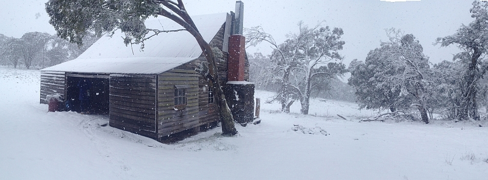
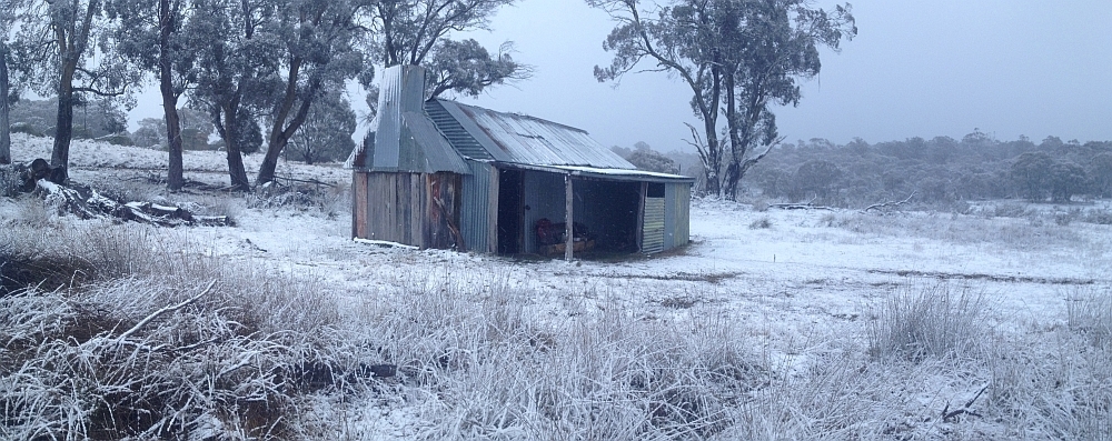
CNP: Tuggeranong Hill NR and Stranger trig recce ! |
Download here |
11.6 |
445 |
M/M; M(9) |
Photos
|
| 1737 |
23 May 26 |
CNP: CBC Navigation Course 6 – Using a GPS Device to Navigate; Trigs and Nature Reserves #4 * |
Download here |
12.1 |
285 |
M/M; E(7) |
Photos
|
| 1636 |
19 May 26 |
Pri: CBC Navigation Course 5 – Introduction to GPS Devices * |
|
|
|
|
|
| 1735 |
16 May 26 |
CNP: Trigs and Nature Reserves #3 * |
Download here |
16.9 |
650 |
L/M; M(11) |
Photos
|
| 1734 |
12 May 26 |
TNR: Short ‘n’ Brutal, Trigs and NRs #2 * |
Download here |
9.7 |
850 |
M/M; M(10) |
Photos and vids
|
| 1733 |
9 May 26 |
CNP: Trigs and Nature Reserves #1 * |
Download here |
17.1 |
655 |
L/M; M(10) |
Photos
|
| 1732 |
6 May 26 |
TNR: Nil Desperandum ! |
Download here |
11.4 |
480 |
M/E; M(8) |
Photos
|
| 1731 |
2 May 26 |
NNP: Stockyard Spur at your own pace * |
Download here |
12.0 |
890 |
L/E; M(10) |
Photos
|
| 1730 |
29 Apr 26 |
GoNR: Easy-Medium Wednesday Walk #2: Goorooyarroo NR * |
Download here |
11.3 |
450 |
M/M; M(9) |
Photos
|
| 1729 |
26 Apr 26 |
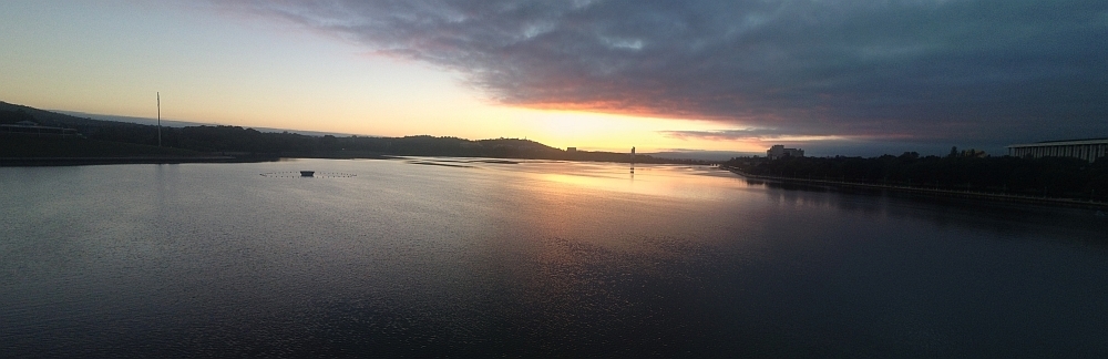
RRNR: Sunset from Big Monks * |
Download here |
4.8 |
300 |
S/R; E(7) |
Photos
|
| 1728 |
25 Apr 26 |
NNP: Glendale Drystone Walls * |
Download here |
10.5 |
645 |
M/R; H(12) |
Photos
Jenny T’s photos
|
| 1727 |
23 Apr 26 |
CRNR: Thursday ramble: off-track along the rocky knolls of Cooleman Ridge |
Download here |
4.6 |
145 |
S/M; E(6) |
Photos |
| 1726 |
20 Apr 26 |
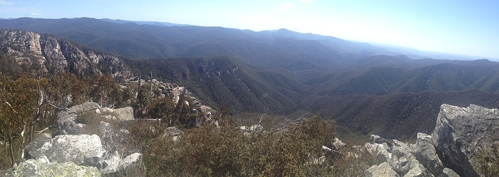
NNP: The Secrets of Mt Tennent * |
Download here |
14.3 |
845 |
L/M; M(11) |
Photos and vid |
| 1725 |
19 Apr 26 |
MTNR: Around Mt Taylor |
Download here |
7.0 |
129 |
S/E; E(5) |
Photo |
| 1724 |
18 Apr 26 |
GoNR: Goorooyarroo NR different * |
Download here |
12.4 |
400 |
M/M; M(9) |
Photos |
| 1723 |
11 Apr 26 |
NNP: Mt Tennent geocaching * |
Download here |
14.7 |
925 |
L/R; H(12) |
Photos |
| 1722 |
4 Apr 26 |
Pri: Molonglo Ridge to Yarrow Pic * |
Download here |
20.0 |
990 |
L/M; H(12) |
Photos |
| 1721 |
1 Apr 26 |
TNR: Banguu Track plus * |
Download here |
11.3 |
825 |
M/M; M(10) |
Photos |
| |
29 Mar 26 |
ABC Radio Interview with Alice Matthews |
|
|
|
|
|
| 1720 |
28 Mar 26 |
TNR: North Mindjagari Track * |
Download here |
19.3 |
1055 |
L/M; H(13) |
Photos |
| 1719 |
24 Mar 26 |
TNR: Tidbinbilla Peak via Banguu Track * |
Download here |
8.5 |
735 |
M/M; M(9) |
Photos |
| 1718 |
21 Mar 26 |
DNP: Big Hole and Marble Arch * |
Download here |
12.6 |
515 |
M/M; M(9) |
Photos and vids |
| 1717 |
17 Mar 26 |
TNR: Mt Domain geocaching * |
Download here |
12.9 |
790 |
L/M; M(11) |
Photos |
| 1716 |
14 Mar 26 |
NNP: Boboyan Divide * |
Download here |
20.2 |
640 |
L/M; M(10) |
Photos |
| 1715 |
9 Mar 26 |
THNR: Tuggers Hill and flank * |
Download here |
5.4 |
290 |
S/M; E(6) |
Photo |
| 1714 |
7 Mar 26 |
NNP: RAMSAR Wetlands, Upper Ginini Falls, Westernmost point of the ACT, Mt Franklin * |
Download here |
9.9 |
420 |
M/R; M(9) |
Photos and vid |
| 1713 |
3 Mar 26 |
NMNR: Nadjung Mada explore * |
Download here |
5.4 |
95 |
S/E; E(4) |
Photos |
| 1712 |
1 Mar 26 |
Pri: Weetangera Methodist cemetery, Pine Ridge trig and about * |
Download here |
6.7 |
180 |
S/M; E(6) |
Photos |
| 1711 |
28 Feb 26 |
MTNR: Mt Taylor 3 times * |
Download here |
9.0 |
570 |
M/M; M(8) |
Photos |
| 1710 |
26 Feb 26 |
BRNR: Murrumbidgee Ramble |
Download here |
7.5 |
345 |
S/E; E(6) |
Photos |
| 1709 |
22 Jan 26 |
MGNR: Molonglo Gorge |
Download here |
6.8 |
275 |
S/E; E(5) |
Photos |
| 1708 |
17 Jan 26 |
Pri: Weetangera Methodist Cemetery ! |
Download here |
0.5 |
5 |
S/E; VE(3) |
Photos |
| 1707 |
4 Jan 26 |
KNP: Snowies Alpine Walk Day 4 – Perisher Valley to Bullocks Flat * |
Download here |
12.6 |
265 |
M/E; E(7) |
Photos and vids |
| 1706 |
27 Dec 25 |
BRNR: The Chasm with family ! |
Download here |
4.8 |
120 |
S/M; E(6) |
Photos |
| 1705 |
16 Dec 25 |
WNR: Belconnen Mine ! |
Download here |
4.0 |
165 |
S/R; E(7) |
Photos |
| 1704 |
13 Dec 25 |
ACTF: NPA Bogs and Fens Field Education event |
|
0.4 |
30 |
S/M; E(5) |
Photos |
| 1703 |
4 Dec 25 |
NH: Narrabundah Hill |
Download here |
5.7 |
135 |
S/E; E(6) |
Photos |
| 1702 |
28-29 Nov 25 |
CCT: Forde to Hall, night * |
Download here |
20.2 |
515 |
L/E; M(10) |
Photos |
| 1701 |
27 Nov 25 |
MRC: The Chasm * |
Download here |
5.4 |
150 |
S/M; E(7) |
Photos |
| 1700 |
27 Nov 25 |
CR: NPA Wildlife Photography Workshop |
Download here |
1.9 |
20 |
S/E; VE(3) |
Photos |
| 1699 |
26 Nov 25 |
MRC: E-M WW Forster Hill and Murrumbidgee Walking Track |
Download here |
11.0 |
645 |
M/M; M(9) |
Photos and vid |
| 1698 |
23 Nov 25 |
SCNR: Below Brindabella Road ! |
Download here |
4.1 |
235 |
S/R,X; M(8) |
Photos |
| 1697 |
20 Nov 25 |
UHNR: Urambi Hills and Murrumbidgee River |
Download here |
6.8 |
250 |
S/M; E(7) |
Photos and vid |
| 1696 |
17 Nov 25 |
TNR: Short ‘n’ Brutal + The Pimple * |
Download here |
12.6 |
1060 |
L/R; H(13) |
Photos and vids |
| 1695 |
15 Nov 25 |
NNP: Mt Tennent * |
Download here |
14.0 |
815 |
L/E; M(9) |
Photos |
| 1694 |
13 Nov 25 |
Pri/GiNR: William Farrer’s Grave and De Salis Cemetery * |
Download here |
4.8 |
100 |
S/M; E(5) |
Photos |
| 1693 |
11 Nov 25 |
MRC: Murrumbidgee Discovery Track * |
Download here |
10.6 |
285 |
M/E; E(6) |
Photos |
| 1692 |
8 Nov 25 |
CBNR: Navigation Course Session 6 * |
Download here |
6.0 |
150 |
S/E; E(6) |
Photo |
| 1691 |
6 Nov 25 |
MFNR: Sammys Hill |
Download here |
5.4 |
125 |
S/E; E(5) |
Photos |
| 1690 |
4 Nov 25 |
MTNR: Around Mt Taylor – testing Naismith’s Rule * |
Download here |
6.5 |
160 |
S/E; E(5) |
Photo |
| 1689 |
1 Nov 25 |
TNR: Southern Mindjagari Track Geocaching – Snowy Corner Traverse * |
Download here |
12.3 |
925 |
L/M; H(12) |
Photos and vids |
| 1688 |
30 Oct 25 |
THNR: Daylight Savings evening walk – Tuggeranong Hill * |
Download here |
4.1 |
265 |
S/M; E(7) |
Photos |
| 1687 |
28 Oct 25 |
MoRC: Barrer Hill and Misery Point |
Download here |
6.4 |
210 |
S/E; E(6) |
Photos |
| 1686 |
27 Oct 25 |
TNR: Banggu Loop ! |
Download here |
12.5 |
770 |
L/E; M(10) |
Photos |
| 1685 |
25 Oct 25 |
TNR: Camels Hump plus * |
Download here |
14.9 |
720 |
L/M; M(11) |
Photos and vid |
| 1684 |
23 Oct 25 |
RRNR: Big Monks * |
Download here |
4.5 |
280 |
S/M; E(6) |
Photos |
| 1683 |
22 Oct 25 |
THNR: Tuggeranong Hill – not an easy descent ! |
Download here |
5.5 |
270 |
S/R; M(8) |
Photos |
| 1682 |
20 Oct 25 |
THNR: Tuggeranong Hill ! |
Download here |
6.1 |
290 |
S/M; E(7) |
Photos |
| 1681 |
18 Oct 25 |
Urb: Urban Worn Boot Bash |
Download here |
30.1 |
1220 |
L/E; H(13) |
Photos |
| 1680 |
17 Oct 25 |
TNR: Opening of the Mindjagari Track |
|
|
|
|
Photos |
| 1679 |
14 Oct 25 |
ANU: Brown Hill and Mt Stromlo for the Conservation Council * |
Download here |
8.6 |
270 |
S/E; E(6) |
Photos |
| 1678 |
12 Oct 25 |
ANU: Brown Hill and Mt Stromlo * |
Download here |
8.7 |
300 |
S/E; E(6) |
Photos |
| 1677 |
6 Oct 25 |
MRC: Whitlam from Denman Prospect |
Download here |
10.2 |
190 |
S/E; E(5) |
Photos |
| 1676 |
5 Oct 25 |
THNR: Tuggeranong Knolls and the Theodore Axe Grinding Grooves * |
Download here |
5.3 |
215 |
S/E; E(5) |
Photo |
| 1675 |
4 Oct 25 |
NNP: Mt Tennent ! |
Download here |
14.1 |
805 |
L/E; M(9) |
Photos |
| 1674 |
28 Sep 25 |
NNP: Gudgenby Grasslands with rocks |
Download here |
7.8 |
195 |
S/M; E(7) |
Photos and Vids |
| 1673 |
23 Sep 25 |
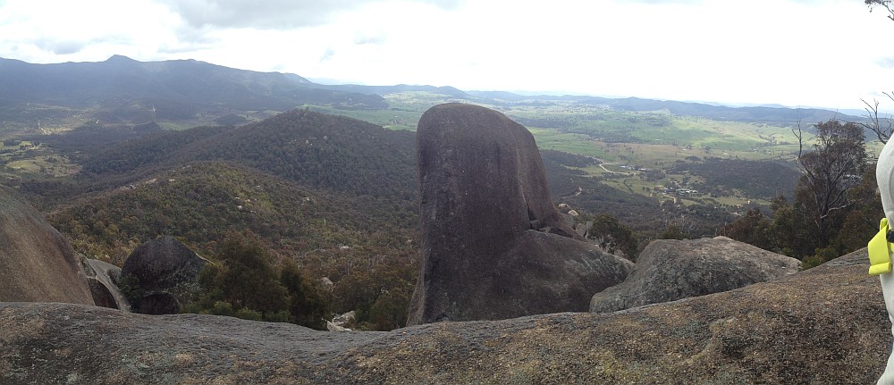
NNP: Smiling Rock ! |
Download here |
7.9 |
495 |
M/R,X; M(10) |
Photos and Vid |
| 1672 |
22 Sep 25 |
BB: Bluetts Block for the Conservation Council * |
Download here |
6.1 |
260 |
S/M; M(7) |
Photos |
| 1671 |
21 Sep 25 |
BB: Bluetts Block for the Conservation Council * |
Download here |
6.9 |
310 |
S/M; M(7) |
Photos |
| 1670 |
14 Sep 25 |
MRC: The Chasm * |
Download here |
5.6 |
150 |
S/R; M(8) |
Photos and Vids |
| 1669 |
13 Sep 25 |
BB: Bluetts Block * |
Download here |
6.9 |
310 |
S/M; M(7) |
Photos |
| 1668 |
12 Sep 25 |
MRC: Chasm recce ! |
Download here |
6.2 |
170 |
S/R; M(8) |
Photos |
| 1667 |
8 Sep 25 |
SCNR: Murrumbidgee River from near Cotter Pines ! |
Download here |
5.1 |
195 |
S/E,X; E(5) |
Photos |
| 1666 |
6 Sep 25 |
NNP: 1220+m Knoll South of Yankee Hat carpark * |
Download here |
6.5 |
240 |
S/R,X; M(9) |
Photos |
| 1665 |
2 Sep 25 |
SCNR: A look-see in Stoney Creek Nature Reserve ! |
Download here |
5.7 |
230 |
S/E,X; E(4) |
Photos |
| 1664 |
31 Aug 25 |
ACTF: Sherwood Daffy-dills * |
Download here |
9.2 |
370 |
M/E; E(7) |
Photos |
| 1663 |
30 Aug 25 |
RRNR: A Circuit of Rob Roy Nature Reserve * |
Download here |
11.4 |
660 |
M/M; M(10) |
Photos |
| 1662 |
27 Aug 25 |
NNP: M-H WW Orroral Valley Circuit |
Download here |
20.5 |
275 |
L/E; M(9) |
Photos |
| 1661 |
25 Aug 25 |
ACTF: Check out the Sherwood Daffodils ! |
Download here |
2.9 |
55 |
S/E; VE(3) |
Photos |
| 1660 |
23 Aug 25 |
NNP: Bushfold Flats geocaching * |
Download here |
15.7 |
585 |
L/E; M(9) |
Photos |
| 1659 |
22 Aug 25 |
Pub: Brown trig and Mt Stromlo ! |
Download here |
9.98 |
305 |
M/E; E(7) |
Photos |
| 1658 |
20 Aug 25 |
CF: Raggeds Falls and lunch at Captains Flat pub ! |
Download here |
2.6 |
135 |
S/E; E(4) |
Photos |
| 1657 |
17 Aug 25 |
NNP: Yankee Hat Rock Art and about * |
Download here |
13.8 |
385 |
M/M; M(8) |
Photos |
| 1656 |
16 Aug 25 |
BB: Bluetts Block ! |
Download here |
7.2 |
280 |
S/M; E(6) |
Photos |
| 1655 |
13 Aug 25 |
NNP: E-M Wednesday Walk: Yankee Hat Rock Art and surrounding area * |
Download here |
13.2 |
340 |
M/M; M(8) |
Photos |
| 1654 |
12 Aug 25 |
RRNR: Lance Bates Track ! |
Download here |
7.2 |
430 |
S/R,ptX; M(9) |
Photos |
| 1653 |
10 Aug 25 |
THNR: Tuggeranong Hill NR and Theodore Axe Grinding Grooves ! |
Download here |
8.5 |
385 |
S/E; E(6) |
Photos |
| 1652 |
6 Aug 25 |
NNP: Yankee Hat Rock Art ! |
Download here |
7.0 |
165 |
S/E; E(6) |
Photos |
| 1651 |
30 Jul 25 |
NNP: Paddy Smiths Hut site ! |
Download here |
2.7 |
85 |
S/E; E(4) |
Photos |
| 1650 |
27 Jul 25 |
MRC/BRNR: A Search for Maloneys * |
Download here |
17.8 |
450 |
L/M,ptX; M(10) |
Photos |
| 1649 |
23 Jul 25 |
BRNR/Pri: Calvary ! and Lambrigg |
Download here |
14.4 |
350 |
M/M; M(9) |
Photos |
| 1648 |
19 Jul 25 |
BRNR: Bullen Range * |
Download here |
13.5 |
730 |
L/M; M(11) |
Photos |
| 1647 |
14 Jul 25 |
LCCR: Cotter Caching and Mt McDonald ecce ! |
Download here |
4.5 |
255 |
S/E; E(4) |
Photos |
| 1646 |
12 Jul 25 |
LCCR: Cotter Sights and Sites * |
Download here |
14.5 |
480 |
M/E; M(8) |
Photos |
| 1645 |
9 Jul 25 |
BRNR: Bullen Range caching |
Download here |
14.3 |
650 |
M/M; M(10) |
Photos |
| 1644 |
5 Jul 25 |
MRC: Murrumbidgee Discovery Track – Casuarina Sands to knoll lookout |
Download here |
14.9 |
445 |
M/E; M(8) |
Photos |
| |
30 Jun 25 |
Johnny Boy’s Walkabout Blog 20 years in review |
|
|
|
|
|
| 1643 |
29 Jun 25 |
LMRCNR: Tongs Hole to Namarag * |
Download here |
11.0 |
325 |
M/E; M(8) |
Photos |
| 1642 |
28 Jun 25 |
TNR: Under Camels Hump ! |
Download here |
12.7 |
530 |
M/E; M(8) |
Photos |
| 1641 |
25 Jun 25 |
TNR: Exploring Jedbinbilla * |
Download here |
12.8 |
475 |
M/E; M(8) |
Photos |
| 1640 |
21 Jun 25 |
MRC: Around Cotter ! |
Download here |
11.2 |
365 |
M/E; M(8) |
Photos |
| 1639 |
20 Jun 25 |
TNR: Jedbinbilla King Ferns ! |
Download here |
11.6 |
450 |
M/E; M(9) |
Photos |
| 1638 |
10 Jun 25 |
NNP: Nursery Creek to Rendezvous Creek * |
Download here |
11.2 |
490 |
M/R; M(10) |
Photos |
| 1637 |
7 Jun 25 |
ACTF/NNP/BNP: Mt Blundell adit * |
Download here |
13.6 |
670 |
L/M; M(10) |
Photos |
| 1636 |
4 Jun 25 |
MTNR: Cultural tour on Mt Taylor with Tyronne Bell |
Download here |
3.6 |
200 |
S/E; E(4) |
Photos |
| 1635 |
3 Jun 25 |
TNR: Skyline Track filming * |
Download here |
9.8 |
710 |
M/R; M(10) |
Photos |
| 1634 |
1-2 Jun 25 |
NNP: Lutons Crutching Shed camp * |
Download here |
20.7 |
325 |
M/E; E(7) |
Photos |
| 1633 |
24 May 25 |
TNR: Nil Desperandum and surrounds * |
Download here |
12.5 |
500 |
L/E; M(9) |
Photos |
| 1632 |
18 May 25 |
NNP: Adventures in the Southern Namadgi * |
Download here |
22.1 |
590 |
L/M; M(11) |
Photos |
| 1631 |
10 May 25 |
NNP: Four Short Walks from the Boboyan Road * |
Download here |
13.6 |
535 |
M/M; M(9) |
Photos |
| 1630 |
4 May 25 |
NNP: Bendora Arboretum and Bendoura Hill * |
Download here |
9.0 |
310 |
M/M; M(8) |
Photos |
| 1629 |
3 May 25 |
NNP: CBC Heritage Festival Orroral Valley Walk |
|
|
|
|
Photos |
| 1628 |
27 Apr 25 |
TSR: Hall Ring Tree |
|
|
|
|
Photos |
| 1627 |
26 Apr 25 |
GEP: Gungahlin Eucalypt Plantation and Sun Moth area * |
Download here |
19.0 |
610 |
L/M; M(11) |
Photos |
| 1626 |
19 Apr 25 |
TNR/NNP: Camels Hump to Cotter River crossover * |
Download here |
13.8 |
785 |
L/M; H(12) |
Photos |
| 1625 |
16 Apr 25 |
MFNR: Aaron Chatfield’s Bush Tucker walk at Mulligans Flat |
|
|
|
|
Photos |
| 1624 |
5 Apr 25 |
TNR: Tidbinbilla Nature Reserve Ramble * |
Download here |
14.6 |
490 |
M/M; M(9) |
Photos |
| 1623 |
27 Mar 25 |
KNP: Blue Lake and Mt Twynam * |
Download here |
19.3 |
820 |
L/M; M(11) |
Photos |
| 1622 |
23 Mar 25 |
CBNR: Practical Map and Compass Navigation Exercise #11 * |
Download here |
6.7 |
170 |
S/M |
|
| 1621 |
22 Mar 25 |
TNR: Mt Domain * |
Download here |
12.6 |
730 |
M/M; M(11) |
Photos |
| 1620 |
16 Mar 25 |
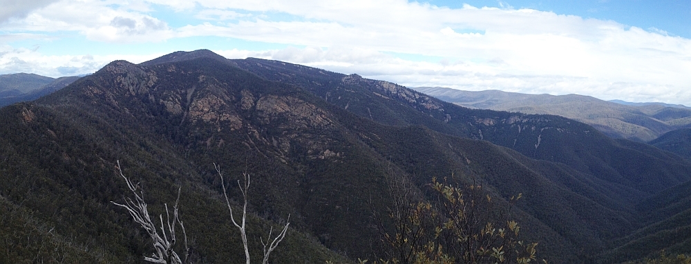
TNR: Camels Hump, Johns Peak, Tidbinbilla Peak * |
Download here |
13.8 |
895 |
L/M; M(11) |
Photos |
| 1619 |
11 Mar 25 |
KNP: Snowies Alpine Walk stage 3 – Charlotte Pass to Perisher * |
Download here |
14.5 |
495 |
M/E,ptX; M(8) |
Photos |
| 1618 |
8 Mar 25 |
WJGNR: Callum Brae and West Jerrabomberra Grasslands NRs for Office of the Commissioner for Sustainability and the Environment ! |
Download here |
7.1 |
175 |
S/M |
Photos |
| 1617 |
2 Mar 25 |
CBNR: Map and Compass Navigation Exercise for the Tumut Bushwalking Club * |
Download here |
6.4 |
160 |
S/M; E(7) |
Photos |
| 1616 |
13 Feb 25 |
RRNR: Big Monks * |
Download here |
4.4 |
270 |
S/M; E(6) |
|
| 1615 |
6 Feb 25 |
Pri: William Farrer’s Grave * |
Download here |
1.9 |
55 |
S/E; E(5) |
|
| 1614 |
30 Jan 25 |
RRNR: Big Monks torch light return * |
Download here |
4.9 |
305 |
S/R; E(7) |
|
| 1613 |
25 Jan 25 |
THNR: Tuggeranong Hill * |
Download here |
5.1 |
255 |
S/M; E(6) |
|
| 1612 |
23 Jan 25 |
ACTF: Narrabundah Hill |
Download here |
5.8 |
135 |
S/E; E(5) |
|