Cotter River and Pipeline Rd from Cotter Hill

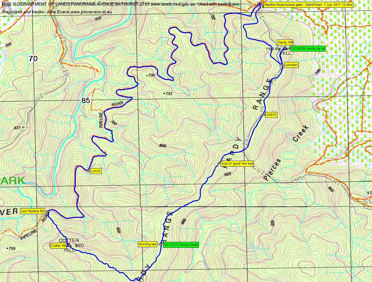
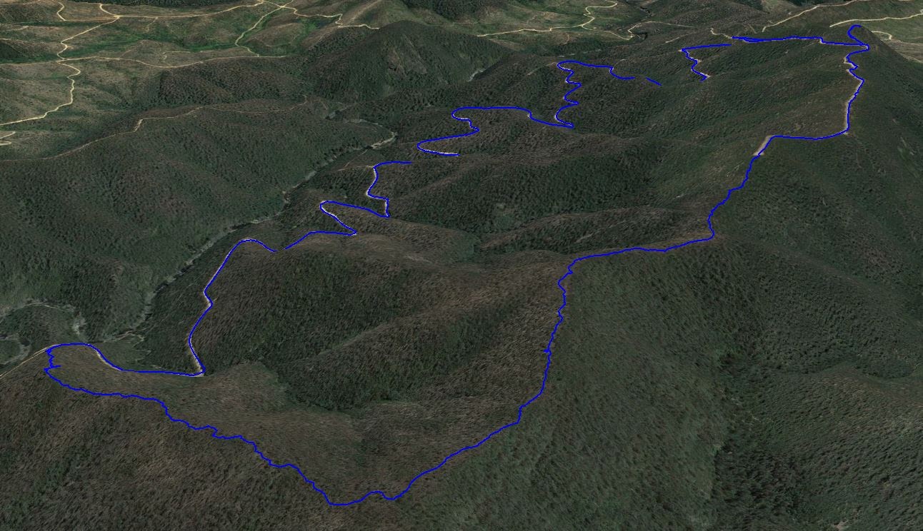
Saturday 1 July: Hardy Range geocaching – M/M-R. Drive to the bottom of Hardy Hill. Walk up an old fire trail to the top for geocache GCWE2M Hardy ha ha. Next, walk the crest of the Hardy Range generally to the SW, first following an old vehicle track alignment which finally peters out, then off-track. We’ll find geocache GC15Z1V Rocky Road. A southerly arc down to Cotter Hill and its stony cairn, then steeply down to Pipeline Road. Walk back up Pipeline Road to the start. Around 12km (4km of which is off-track) and 500m climb. Maps: Cotter Dam and Tidbinbilla. Leader: John Evans 0417 436 877 john@johnevans.id.au . Transport: ∼$10 per person.
Further Information
A while since I was through here, relevant ones on 12 May 09 and 20 Aug 13.
Summary
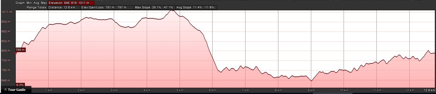
Distance: 12.8km | Climb: 800m | Time: 8.20am – 2.15pm (5hrs 55mins), including 40 mins of breaks | Grading: M/M-R; H(13)
Photographs
Photographs are available, where you can start a large sized slideshow.
Waypoint and Track Files
Download the .gpx file. (Right click, Save Link As…, Save – if you want to use it.)
To use in Google Earth, do File, Open… and select Gps or All files as the File Type.
Track Notes
A bit of churning in the party participants as the day drew near. Thanks to Stephen for driving, as my bush car needs a new oil pressure sensor and if you were 14 years old, you might have to wait a month for a spare part too.
If you weren’t outside today, well …. Even my poor dear wife did 200m on her crutches with me after I got home. It was a magnificent, cold start, blue sky day! -4ºC (forecast -6ºC) as Stephen drove me north from my deep south old folks home. We picked up the rest of the party (there had been some EOFY churning, but eventually 4 came to the party) and we drove out through the Cotter, along Paddys River Rd, down Laurel Camp Rd, west along East-West Rd and up Pipeline Rd to the locked gate at the saddle below Hardy Hill.
Not a breath of wind as we set off from the about 6-way intersection either side of the gate. The correct fire trail to choose, once over the gate, is up. This fire trail is not marked on the current edition Cotter Dam 1:25000 topographic map, but is on the older version. A pleasant tromp up to the junction, where we switched back along the old alignment to Hardy Hill, through the trig, to the nearby cache, GCWE2M Hardy ha ha. Roger found it at around 17m from the advertised location, so Noikmeister’s and Fox in Joxs corrections are correct. Duly logged.
Returning to the junction, we enjoyed 1.4km of good fire trail taking us SW along the crest of the Hardy Range. It suddenly came to and end!
From there, it was bush ‘whacking’. The regrowth was mostly dry, so relatively easy to crash through. A few patches of more supple eucalypt regrowth. 1.3km in 55mins along the crest of the range, we found and logged GC15Z1V Rocky Road. We sat down for morning tea.
From here, we could look down to the west to a creek system that descended to Pipeline Road. And to the further spur which went down through Cotter Hill. As tempting as it might be, it would be a slow trip down, compared with our chosen route to skirt the top of the bowl and bash on to the spur. Another scrubby leg down to Cotter Hill and its stone trig cairn. As Roger said, one doesn’t often walk down to a trig! Great views down into the wild Cotter River valley.
All that remained was a 500m leg, descending 200 vertical metres (so pretty steep), down to join the Pipeline Road. But better than walking up it.
Down on the road it was all over, but for the 6.6km back up along the twisting Pipeline Road to the car. A stop for lunch once we’d climbed the first hill. The Ranger’s wife from Bendora Dam passed us and stopped for a chat. She was driving into town to do the shopping. I’d met her along this road before.
The creeks which must tumble down to the Cotter River in the wet have had post 2003 fire work and some of the gabion walls are worth a look.
We had a newbie with us today. Always a challenge to take a self-assessed, site unseen walker out with top mates and walkers. Janet starred – strong walker, not one complaint and even appreciated the ducking and weaving bush whacking as a good gym workout. A great walking companion. She wore a down jacket all day (as she’s from the West)!
Top little trip. We were back in Canberra at brownie point time. Thanks all. And a 2-cache day to boot.
Track Map
Party
4 walkers – Roger E, Stephen M, Janet P, me.