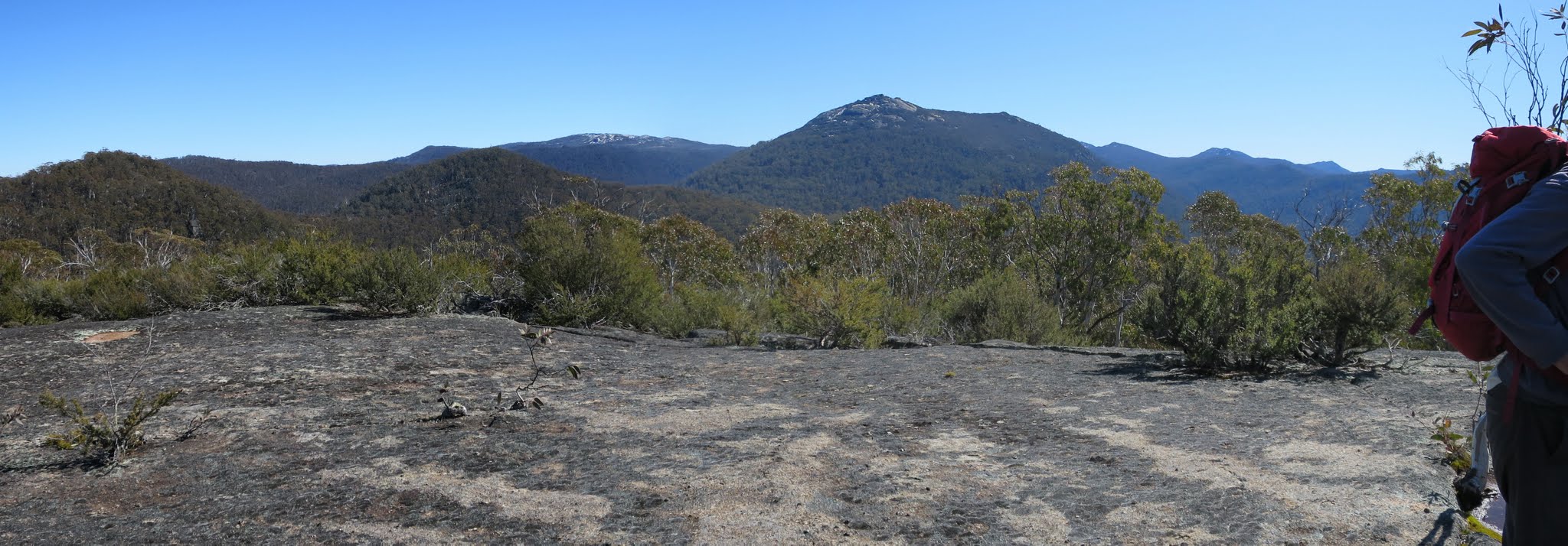
A little snow on Mts Scabby and Gudgenby from the slab
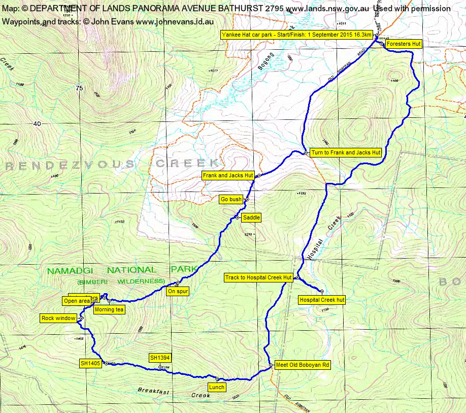
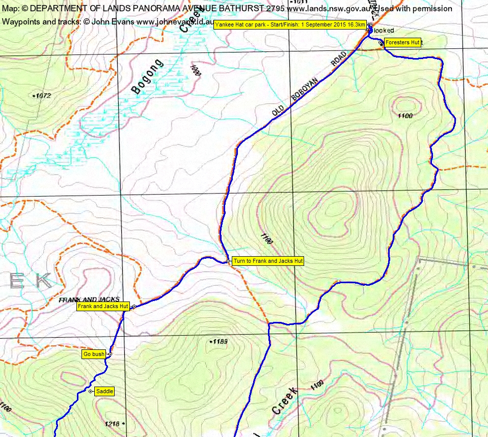
Tuesday 1 September: Rocks above Breakfast Creek – M/R. A walk to a pleasant small plateau edged by massive boulders and slabs, to the east of Gudgenby. From Yankee Hat car park to Frank and Jack’s Hut and then south-west up onto the plateau through moderate scrub to some extensive rocky areas with great views. Return to the Old Boboyan Rd via a long spur with more granite and reasonable scrub. Around 16 km and 240 m climb. Map: Yaouk. Leader: John Evans 0417 436 877 john@johnevans.id.au . Transport: ∼$40 per car.
6 of us drove in 2 vehicles to the Yankee Hat car park.
Further Information
Jenny H, whose trip this was, had gone to Queensland flying and we don’t know where she are.
Summary
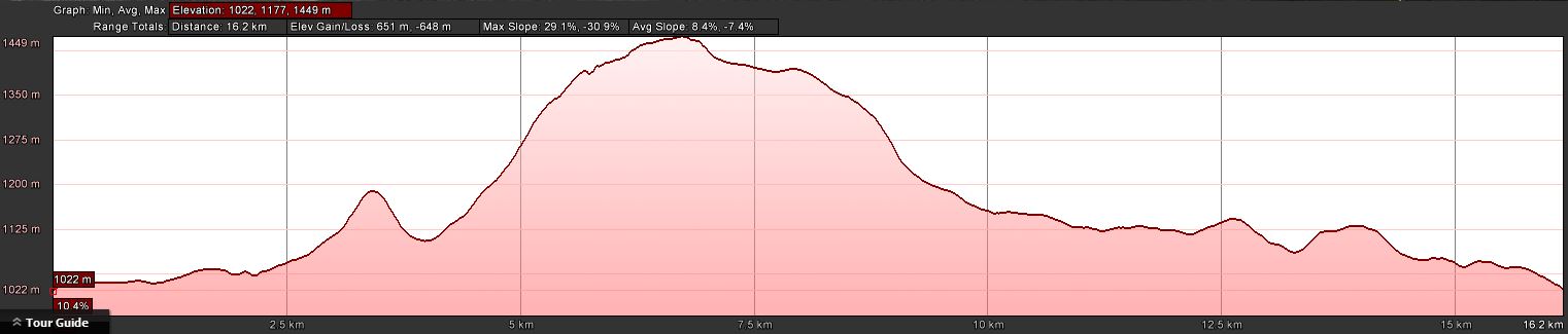
Distance: 16.3km | Climb: 650m | Time: 8.35am-2.50pm (6hrs 15mins), including 55 mins of breaks | Grading: L/M-R,ptX; H(12)
Photographs
Photographs are available, where you can start a large sized slideshow.
Videos
Waypoint and Track Files
Download the .gpx file. (Right click, Save Link As…, Save – if you want to use it.)
Download the .kml file.
Track Notes
A perfect spring day! Cool (frost, and some ice in Hospital Creek at the fords into Yankee Hat car park), but warm out of any breeze during the day under a blue sky!
We shook out and wandered in to Frank and Jacks Hut, taking a few minutes for those who hadn’t been here before to have a peek in.
Then up the old fire trail to the south of the hut to go off-track into the bush. It was a relatively easy circuit, planned to use slightly different entry and exit routes to Linda G’s named ‘The Granite Garden’ that Ian W led on 20 Apr 13 and 20 Nov 12. A short climb to a saddle, then down to the 1100m contour and a drift round to pick up a spur that runs up to the tor area. The going was woodland with scrubby wattle under-story in places.
We had morning tea at the first of several tors in the area and, afterwards, did a tour of the fantastic granite blocks grouped here. This area is well worth a visit. Using a shorter, more direct route from a previous visit, it would make a great destination for a Wednesday or weekend day-walk.
I was going to begin the exit via SH1468, but thank goodness that Ian had brought a waypoint for a granite slab north of this SH. Ian led this leg and brought us to the slab with its fantastic views of the high hills to the west.
Back under my command, we exited via a relatively uninteresting ridge and gentle spur which began at SH1405, through SH1394 and lunch, to join the Old Boboyan Road.
We tromped north along it and took the track down to Hospital Creek Hut, another destination not previously visited by a couple of the party.
Finally, to negate the ‘there and back’, we returned via the fire trails to the east of the hill south of the car park. An opportunity to have a closer view to the ‘face’ on the side of Hospital Hill, to visit the Foresters Hut which again a couple hadn’t previously seen, and so back to the cars.
There was a car on the car park when we arrived, gone when we returned but a note from Stephen M on my windscreen when we returned.
Thanks all. Trust we were reasonably true to Jenny’s route. A very enjoyable first of spring day.
Timings
| From | To | Distance | Time |
| Start | Frank and Jacks Hut | 2.7km | 32 mins |
| Frank and Jacks Hut | Morning tea | 2.9km | 1hr 20mins |
| Morning tea | Slab with views | 0.8km | 31 mins |
| Slab with views | Lunch | 2.3km | 1hr 10mins |
| Lunch | Meet Old Boboyan Rd | 0.8km | 22 mins |
| Meet Old Boboyan Rd | Hospital Creek Hut | 1.8km | 25 mins |
| Hospital Creek Hut | Finish | 5.0km | 1hr 5mins |
A magnificent male Lyrebird on the side of the Boboyan Road as we drove home.
Time for an interview on 2CC at 5.30pm when I got home. An opportunity to plug the Canberra Bushwalking Club and the joys of bush walking with Marcus Paul, who wanted an emphasis on the first day of spring. Fortunate that we’d been walking and the station had been trying to contact me all day.
Then off to the H’s ‘Navigation Refresher’ course session 1. 10 starters! Great!!
Track Maps
Track overview
Track 1
Track 2

Profile
Party
6 walkers – Meredith H, Roger H, Jonathan M, Lorraine T, Ian W, me.
Next Tuesday Walk
Tuesday 8 September: Yankee Hat Slabs and Middle Creek, Namadgi National Park – L/R/partX. Starting from the Yankee Hat carpark we will ascend to the crest of the Yankee Hat ridge via the creek and saddle between the two peaks. There are excellent granite tors and extensive views near grid ref. 746418. We will then descend to Middle Creek via a route that links up a number of large tors on the northern flank of Yankee Hat. This is a difficult, off-track walk. There is thick scrub for much of the day and steep rocky slopes to negotiate. Minimum distance: 14 km with ∼600 metres of ascent. Maps: Rendezvous Creek, Yaouk. Leader: Ian W. Transport: 110 km return. Limit: 8.