Mt Jagungal from the east

Friday–Sunday 10–12 February: Cesjacks Hut and Mt Jagungal – M/R. Friday 1:00 pm departure for northern KNP via Cooma, leaving cars at the KNP gate and walk in to Cesjacks Hut camp (~2.5 km). On Saturday, high alpine off track walking to climb Mt Jagungal, 15 km return to Cesjacks Hut and about 900 m total ascent. Return to cars Sunday for the drive home. Map: Jagungal. Leader: Rowan P. Transport: ~$280 per car, 4WD required. Limit: 8.
Further Information
My previous trips here were 1-2 Dec 09 and 23-25 Mar 10.
Summary
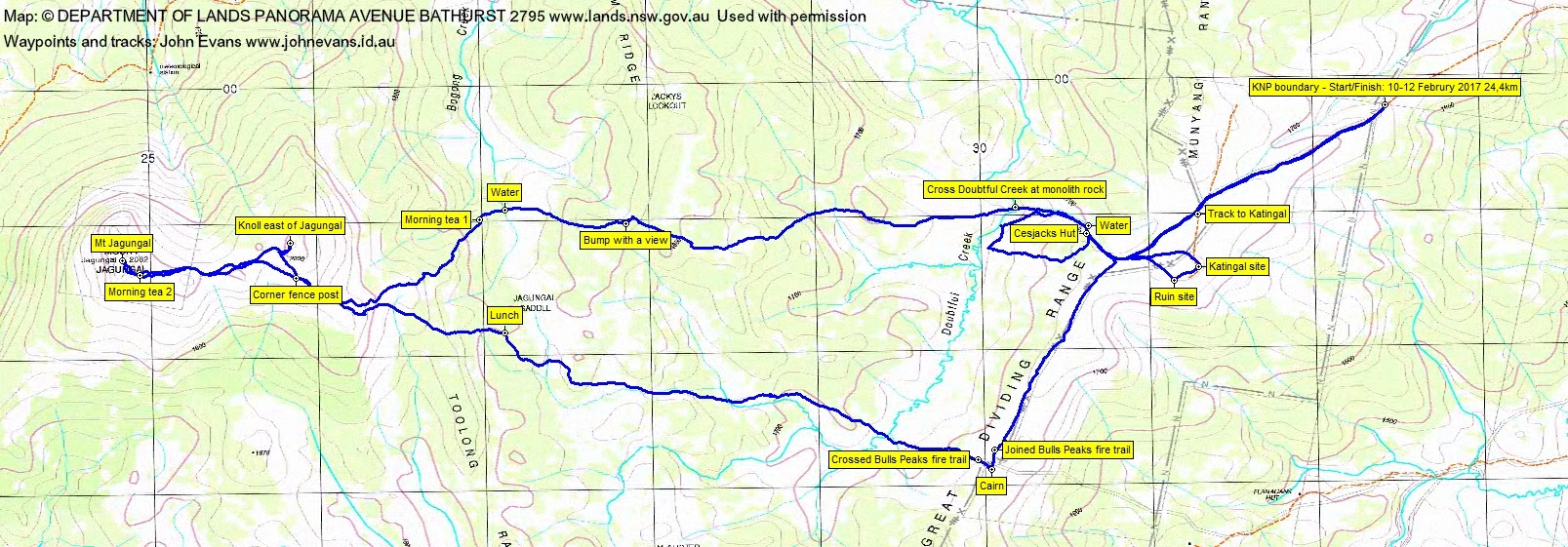
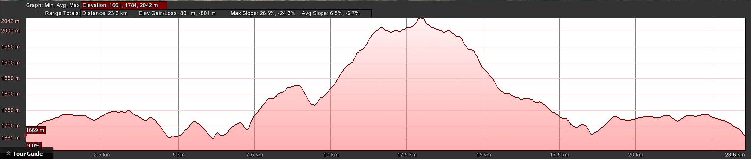
Distance: 24.4km | Climb: 800m | Time: ½day + ¾ day + ¼ day | Grading: M/R; M(11)
Photographs
Photographs are available, where you can start a large sized slideshow.
Videos
(no sound recorded)
Waypoint and Track Files
Download the .gpx file. (Right click, Save Link As…, Save – if you want to use it.)
To use in Google Earth, do File, Open… and select Gps or All files as the File Type.
Track Notes
Day 1
We left Canberra at 2pm on Friday in 40ºC. It was probably about 15ºC in the big V8 Land Cruiser, which handled the Nimmo Rd, Gungarlin River ford, Snowy Plains Fire Trail and Bulls Peaks Creek ford with consummate ease. Reached the boundary of KNP around 4.45pm.
A short 2.3km walk in 40mins to Cesjacks Hut under a blue sky. Quite warm.
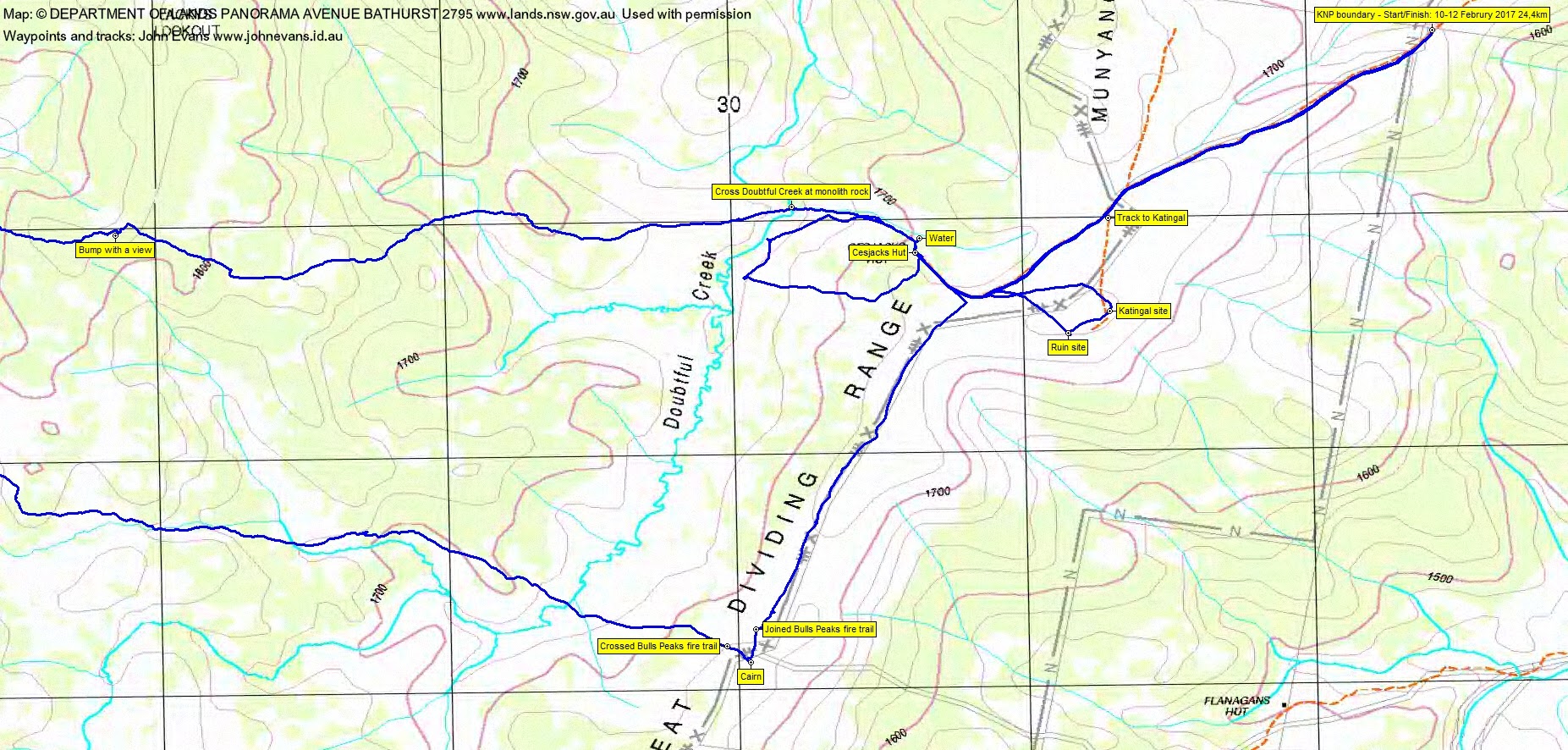
Whilst the others set up camp, Tony and I went for a short wander to ‘Katingal’ and ‘Ruin’ which I’d seen on the first edition Khancoban 8525-N 1:25000 map. Just a clear, level ground form for Katingal; granite blocks and small bits of concrete for the latter. There was a copy of Robert Green’s Exploring the Jagungal Wilderness in Cesjacks and there is reference to these old private lodges on page 51. 1.7km in 30mins.
After tea I went for a little wander around the hill west of the hut and down to Doubtful Creek to catch the evening light for a couple of snaps. Came back in through the water point for the hut and up the footpad. 1.6km in 30mins.
It was a magnificent night, the night before full moon, so very bright all night. Warm.
Day 2
With a warm day forecast, we were up at 6am, in time to see the sun rise and the moon set. Away at 7am with a day walk load. I use my full pack which can be cinched up to lessen the volume. Always wise to carry gear for changeable weather in the high country.
We left via the footpad down to the water point and followed the feeder creek down to Doubtful Creek. I’d spied a good crossing point the previous evening, marked by a large menhir monolith on the opposite bank. Again, this point is documented in Robert Green’s Exploring the Jagungal Wilderness on page 50.
Beautiful walking under blue skies, although the wind was strong. Rowan led us generally west to a bump (not evident in the map segments with 20m contour intervals) with a view. Nice views, particularly to the west and south. We crossed to the north of the map-marked Jagungal Saddle and picked up some water from Bogong Creek. Morning tea #1 was taken soon after, at 9.15am. 4.3km in 2hrs 15mins to here.
Following the more open leads, we dipped to the south-west a bit then back to the north-west as we climbed to the open tops east of Mt Jagungal. Passed a fence post I remember from a previous trip and climbed the 2020m knoll to the east of Jagungal. Great views; windy. Check out the video clip. Once down, we skirted another couple of bumps and climbed the final ramp and easy chute to the concrete pillar atop Mt Jagungal. Again, check out the video clip for the views. I especially like the southern view from the top. The leg from morning tea #1 to the top was 3.3km in 1hr 35mins.
Down out of the strong wind we had morning tea #2. It was here that the showers sweeping in from the south-west caught us. Raincoats on. We found some little shelter under a snow gum SW of Jagungal Saddle for lunch. From the top to lunch was 2.9km in 1hr 30mins.
Our plan for the return, suggested by my mate Max S, was to follow the open creek line which rises in the Saddle and flows down into Doubtful Creek. This we did. A nice change of aspect, scenery and going. Max had told me that from crossing Doubtful Creek, the going was open as it rose to the Great Dividing Range and the faint Bulls Peaks Fire Trail. That it was. There was a rock with a cairn on it that was worth a visit, he’d said.
Now a rock with a cairn on it conjures up many different pictures. We saw the rock from a couple of kilometres out and, once climbed, the cairn was in equally large proportion. A beauty! (See the comment from Greg Hutchison below about the cairn. Greg knows this area like the back of his hand and his name occurs several times in Robert Green’s Exploring the Jagungal Wilderness book.
Back down and returned to Cesjacks along the fire trail. Our second Copperhead snake for the day – I was too slow to snap it. Back in by 3.30pm. The leg from lunch via the creek line and rock was 5.7km in 2hrs 5mins.
It had stopped raining. A lazy time reading the hut log book and Robert’s book.
Day 3
At 30 minutes past midnight, after the full moon light as I went to sleep, a different light and sound show began. Huge amounts of lightening, the thunder rolling around and around the hills, tent-shaking wind gusts and pelting rain. Several storms came over as the night progressed. But we all stayed dry, even the tarp-er.
Up before 6am, taking advantage of a lull in the weather to pack up and move into the hut. Brekky. The morning’s planned walk cancelled, as there was concern about the drive out. Left at 7.50am and walked out to the car.
A safe trip out, thanks to Tony and his big truck. Rowan, who forded the Gungarlin to show the depth going in and out, said the river had risen 10cm.
Great trip, thanks Rowan and all.
Track Maps

Party
5 walkers – Tony B, John H, Brendan K, Rowan P (leader), me.
Greg Hutchison
13 February , 2017 11:11 amHi John. Yes that a nicer way to get to Jagungal. Did you get across Bulls Head Ck OK and was there any issues getting through gates along there. I heard there is a new gate after the creek. Also this weekend was very hot 40-41 in Canberra. Hope it wasn’t too hot for you
Johnny Boy
13 February , 2017 12:26 pmHi Greg
No worries for a V8 Land Cruiser at Bulls Peaks Creek crossing. We thought about the bridge at the Gungarlin ford coming out, but it looked too narrow for a late model Cruiser. No problems with gates. No, not too hot, warm on Friday arvo, but the wind kept the temperature down on Saturday before the showers came.
Thanks heaps for the notes on the cairn.
Greg Hutchison
13 February , 2017 11:17 amThat rock with a cairn on it donates where there was an old bridle trail down in the Bulls Creek Valley. It now donates where skiers can go down to a ridgeline picking up a 4WD past Bulls Pk lodge and down to Bulls Peak Ck where there are several private huts. You can walk through there and into KNP and then down to Gungarlin camp arfea