Clowns in Spring Creek gorge

Wednesday 10 August: Queanbeyan River & Spring Creek Gorge – M/R. This is the Wednesday Walk, harder option. From the new Day use area on Woolcara Lane, climb 150 metres through glades and scrub to the trig on Corner Hill, then descend 200 m to the large pool on the Queanbeyan River at 124 E, 624N (GDA94). Then upstream, mostly about 50 metres above the river with views of its pools and rapids, to the junction of Spring Creek. The creek has a small interesting gorge and several cascades. Return to the cars via ridge tops. About 8 km, some rock scrambling and loose sloping ground but at a moderate pace, mostly forest with light scrub and wildflowers, and a few patches of thick scrub. The water quality in the river is similar to the Murrumbidgee’s. A one hour drive from Queanbeyan, suitable for larger 2WDs. Leader: Linda G. Map: Captains Flat. Transport: $40 per car. No need to book, but Wed Walk participation rules (see elsewhere in It) apply. Meet at Spotlight carpark, 6 Bungendore Road, Queanbeyan, at 8.30 am.
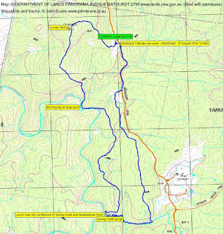
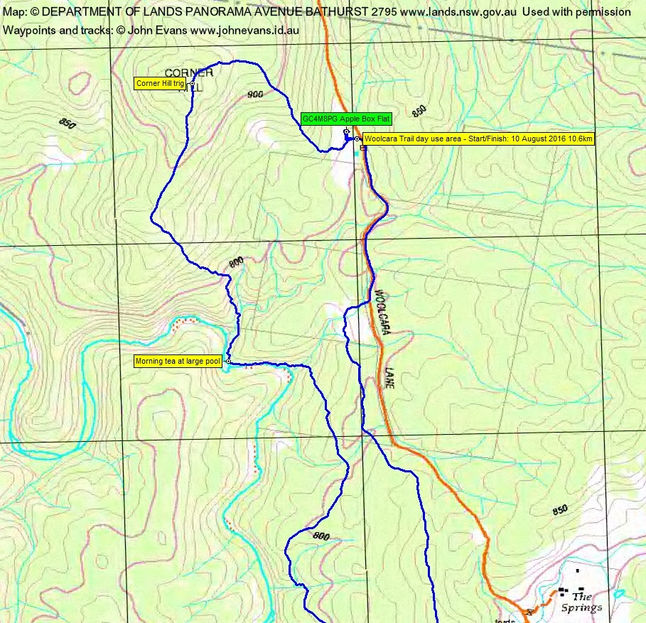
20 of us met and drove in 4 SUVs via the Captains Flat Rd, Woolcara Lane into the Yanununbeyan Nature Reserve and parked at the new day use area.
Further Information
Picasa has finally folded and Google Photos currently provides no method to embed photos. So links only from now on, until Google gets its act together 👿 .
Summary
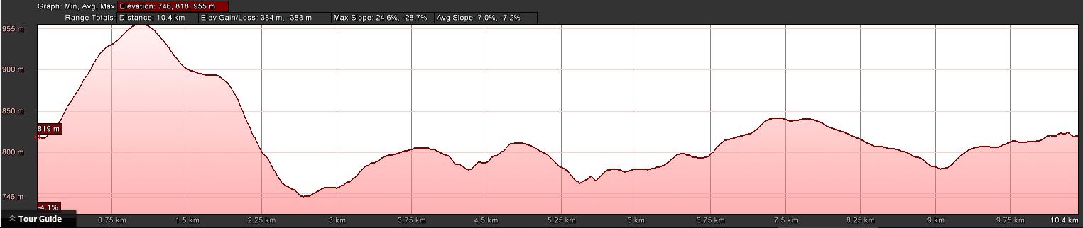
Distance: 10.6km | Climb: 380m | Time: 9.25am – 3.15pm (5hrs 50mins), including 65 mins of breaks | Grading: M/M-R; M(10)
Photographs
Photographs are available, where you can start a large sized slideshow.
Videos
Waypoint and Track Files
Download the .gpx file. (Right click, Save Link As…, Save – if you want to use it.)
To use in Google Earth, do File, Open… and select Gps or All files as the File Type.
Track Notes
The day cleared as forecast and by the time we reached the Queanbeyan River it was blue sky and a little breeze.
But first we shook out and climbed to Corner Hill. A little band of scrub kept us bunched up, then the going opened into woodland. A generous NSW trig on the hill.
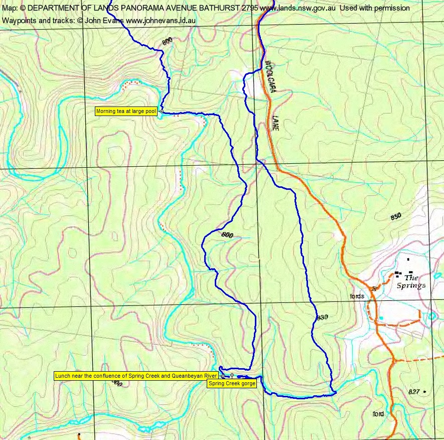
From there a southerly spur and a deliberate fall off the side took us to the first of Linda’s great destinations for the day – a lovely pool on the Queanbeyan River with shingle beach for morning tea.
We followed the river upstream on the water’s edge for a few hundred metres, lovely pools. We then tracked south for a couple of km at around the 800m contour. A couple of drainage lines were crossed. A short, sharp descent had us at the second objective of the day, near the confluence of Spring Creek (not named on the 1:25,000 map) and Queanbeyan River.
The bottom of the gorge was a great place. We had a short squizz, then lunch.
A wonderful time for the next hour! Linda led us up the side of the gorge, then down to the top of the major cascades. We made our way slowly and carefully back down the gorge. The last drop where the clowns were frolicking was substantial and the photo doesn’t do it justice. Then back upstream, past pools in the gorge then out into more creek like going.
At last it was time to leave Spring Creek and we turned north for home.
Back on Woolcara Lane, I was joined by an encourager and a skeptic (both very useful) on a dash back to the cars to search for a geocache. Not being a very flash finder I appreciated their help, but it was another party member who suggested I turn over a soil-encrusted slate to reveal GC4M8PG Apple Box Flat. Duly logged. A bonus for the day.
Thanks again for a great day Linda and to new and old friends.
Track Maps
Party
20 walkers – Melinda B, Maude C, Peter D, Robert D, Shirley F, Liz F, Eric G, Linda G (leader), Leigh H, Jenny H, Colleen M, Mike M, Rod M, Mark P, Leon P, Terrylea R, Barrie R, Alison S, Jenny S, me.