Bullen Range

Tuesday 10 November: Bullen Range Nature Reserve – M/M-R. A circuit around the Bullen Range Nature Reserve. Starting from the Tidbinbilla Tracking Station cross the Bullen Range to the Murrumbidgee and follow it south to Pine Island. Back up and over the Bullen Range to the tracking station. My aim is to locate two geocaches GC4KRPR and GC62XD4. Mainly on track and through woodland but there will also be some thick scrub and steep ridges to negotiate. About 500 metres of ascent. Maps: Tidbinbilla and Tuggeranong. Leader: Roger E. Transport: ∼$5 or $6 per person. Limit 8.
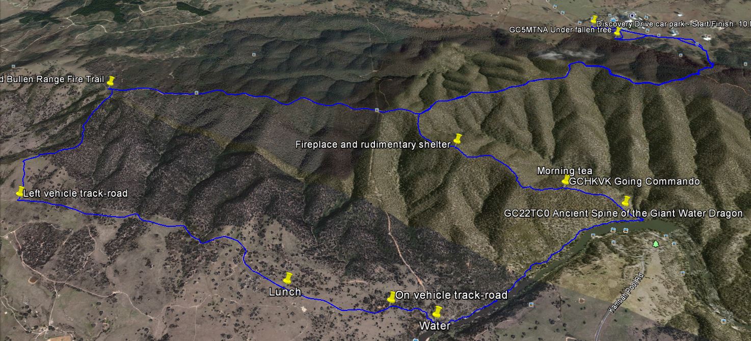
7 of us drove in 2 vehicles via the Cotter to park on the side of Discovery Drive just before the tracking station car park.
Summary
Distance: 22.2km | Climb: 700m (GPSr)-900m (Google Earth) | Time: 8.10am-4.15pm (8hrs 5mins), including 40 mins of meal breaks | Grading: L/R; H(14)
Photographs
Photographs are available, where you can start a large sized slide show.
Waypoint and Track Files
Download the .gpx file. (Right click, Save Link As…, Save – if you want to use it.)
To use in Google Earth, do File, Open… and select Gps or All files as the File Type.
Track Notes
A walk of extremes. The weather varied from a sunny and breathless 30+ºC down along the Murrumbidgee River to thunderstorms, heavy rain and hail during our return along the Bullen Range. The temperature dropped 10ºC. The going varied from a hairy descent of the razor spur that starts on the Bullen Range crest and ends opposite Kambah Pool, to fire trail. I bagged 3 caches (that Roger had done before) and Roger bagged none (due to a shift to plan B).
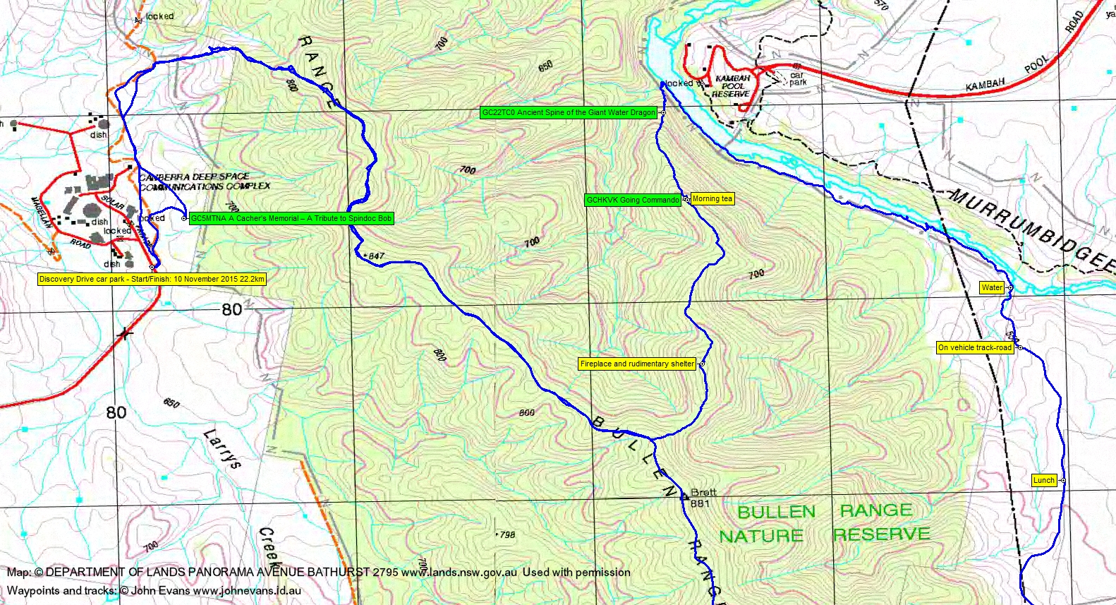
We began along the fire trail that skirts the east side of the Tidbinbilla Tracking Station. That gave me the opportunity to skip up into the tree line and log geocache GC5MTNA A Cacher’s Memorial – A Tribute to Spindoc Bob. Rejoining the party at the gate and fence at the border of the Bullen Range Nature Reserve, we headed off-track up a spur. It was initially open going with great views back down to the dishes. The top was lightly wooded, dry and still easy going. We joined the Bullen Range Fire Trail, the fire trail loop up past the comms tower having been cut off.
A long tromp south-east along the crest fire trail. Quite a few ups and downs.
300m before Brett trig we headed bush and began a pleasant descent of a spur down to the Murrumbidgee River. A dry crest, open woodland and, at the top, just a gentle slope. We paused for a drink at a fireplace and rudimentary shelter. It was getting warm.
We continued the descent which started at around 850m and we paused for morning tea at around 700m. An opportunity to wander around looking for GCHKVK Going Commando, which was finally found very near where a party member was sitting and enjoying munchies.
The descent of the last 150m of the spur, a razor spur by now, gave tremendous views down and across to Kambah Pool and needed a little gentle scrambling at times. One lovely spot held the geocache GC22TC0 Ancient Spine of the Giant Water Dragon. An apt name.
Down at the river, we turned south-east along it. Not as bad as I imagined it would be, with footpads through the vegetation on the river terrace. But there was no breeze and with the phone saying the temperature was 29.1ºC at Tuggeranong, one of our party suffered a little from heat stress. Plenty of rest stops and hat dunks in the river along the way. Roger formulated plan B.
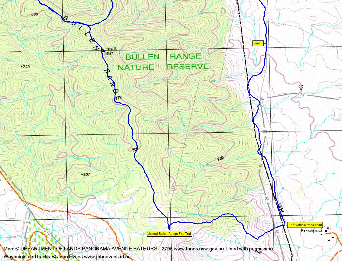
The next side creek after crossing under the powerlines provided a small trickle of water. Some of us filled up and drank. I emptied my electrolyte powder into my pack instead of my drink bottle. Plan B was to leave the river here (and so miss Roger’s caches) and head for ‘Freshford’. As luck would have it, we soon came on the end of a vehicle track/road, I guess for powerline maintenance. This allowed us to cover a bit of distance at a better pace.
Lunch on the side of the track in the shade of a big tree. But the sky was grumbling loud and long.
We continued south along the track and were forced to don raincoats just near ‘Freshford’. Here, two of the party continued south out to the Point Hut Rd. Instead of waiting in the rain and cold, they walked on to Point Hut Crossing.
The rest of the party turned up to the west and climbed 200m back up onto the crest of the Bullen Range. Thunderstorms with heavy rain. Passed an echidna. We gained the Bullen Range Fire Trail.
Turning north, we walked the ups and downs of the FT, through Brett trig and through even heavier rain and hail. It eventually stopped as we could look down to the Tracking Station and it felt like the temperature rose back up the 10ºC it had dropped when the storm front came through.
Back to the cars and return via Point Hut Crossing.
A varied day. Thanks Roger and all.
Timings
| From | To | Distance | Time |
| Start | Join Bullen Range FT | 2.3km | 38mins |
| Join Bullen Range FT | Leave Bullen Range FT | 2.9km | 40mins |
| Leave Bullen Range FT | Morning tea | 1.6km | 42mins |
| Morning tea | Murrumbidgee River | 0.7km | 36mins |
| Walk the bank of the Murrumbidgee River | 2.2km | 1hr 20mins | |
| Water point | Lunch | 1.1km | 25mins |
| Lunch | Leave track | 2.4km | 35mins |
| Leave track | Rejoin Bullen Range FT | 1.5km | 42mins |
| Walk Bullen Range FT to Finish | 7.4km | 1hr 45mins | |
Track Maps
Track overview

Track 1
Track 2
Track on Google Earth
Profile

Party
7 walkers – Roger E (leader), Chris F, Chris R and Cynthia B, Phillip S, Ian W, me.
Next Tuesday Walk
Tuesday 17 November: Headwaters of Honeysuckle Creek – M/M-R,X. Starting at Honeysuckle Creek camp site, a gentle walk along the AAWT for 1.5km, then off track for the rest of the day. Up to Gorilla rocks, then along ridges to the south and west, before finally turning east to circumnavigate the headwaters of Honeysuckle creek. This is an exploratory walk and there is likely to be thick scrub. About 8km and 500m ascent. Map: Corin Dam. Transport: ∼$40 per car. Leader: David H. Maximum: 8 people.
Guy Morrison
20 May , 2016 9:24 amGood on you – you’ve done that beautiful ridge over the other side of Kambah Pool. We did Kambah to Cotter along the Bullen Range many many years ago as a school activity. That walk included all the range except for the interesting/wild bit – Mt Brett – and I still haven’t got round to doing that. Interesting dry bush and metamorphic rock.
Guy Morrison
7 June , 2016 2:54 pmWell actually Kambah Pool was an eerie spot and there was a picturesque ‘staircase’ type of a ridge going up to the left and in the 1970s I thought it looked like a good bushwalk as it went to the top of Mt Brett. The problem was we didn’t really fancy trying to cross the Murrumbidgee in Winter and we were advised not to bushwalk so much in Summer because of snakes – so never did it.
Guy Morrison
10 June , 2016 9:41 amActually it looks like the rock at Mt Brett is a mixture of metamorphic (as in Tidbinbilla Range) and porphrytic dacite (as per here e.g. Mt Taylor). V. interesting area and good to see the photos – I still want to do that walk though Mt Brett always looked like a place worth avoiding…….!