Cliff top views

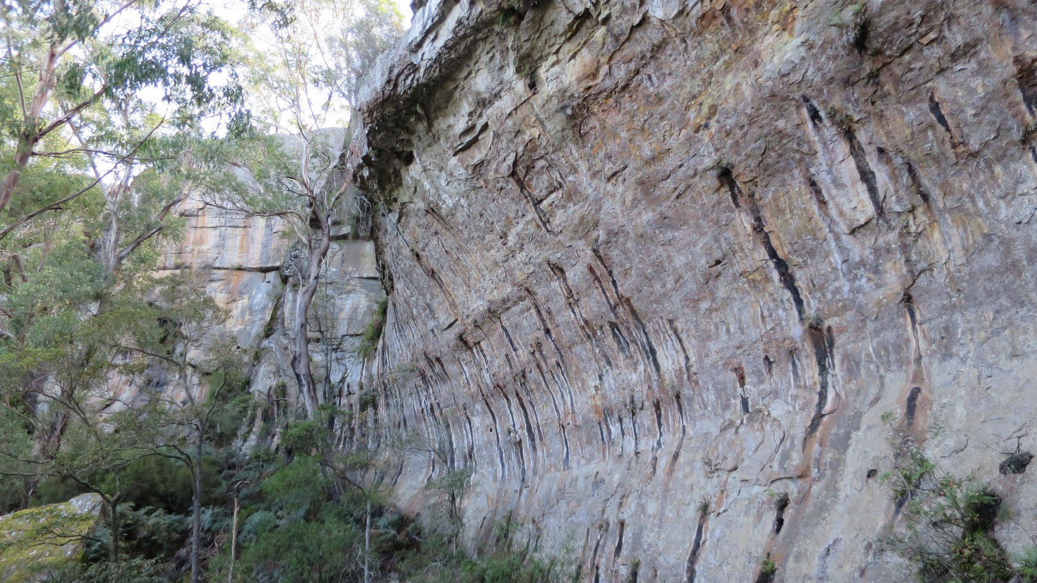
Amphitheatre walls below ‘Skinny Woman Pass’
Wednesday 11 May: Wave Cave – M/R/part X. The Wave Cave is a dramatic overhang in a sandstone cliff in the northern Budawangs. From the Nerriga-Nowra road we will cross a plateau area of forest and flowering heath, then descend on a cairned route through a cliff line to cross Bainbrig Creek and climb to the creek’s southern cliff line. We will explore some of the cliff-base scenery before visiting the Wave Cave. Seven to 10 km, depending on how much exploring we do, of which about 2 km is on fire trail and the rest is a very rough mixture of scrub, slab walking, cliff-base boulders and creek. Main descent/ascent 150 metres. Around five hours actual walking. About 2 hours drive from Queanbeyan, all on sealed road except for the last 50 metres into the parking spot. Map: Nerriga. Leader: Linda G. Transport: Drive yourself or $16 per person if shared.
16 of us drove in 4 vehicles to the park on the side of the Braidwood-Nerriga Road.
Further Information
My second trip to the area, the first on 8 Jan 16.
Summary
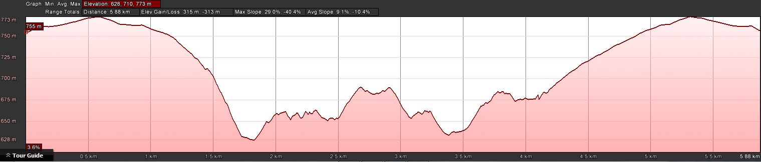
Distance: 6.1km | Climb: 315m | Time: 9.45am-2.50pm (5hrs 5mins), including 40 mins of breaks | Grading: S/R,ptX; M(10)
Photographs
Photographs are available, where you can start a large sized slideshow.
Videos
Waypoint and Track Files
Removed
Track Notes
A drive through Tarago, over the Oallen bridge and through Nerriga to park off the Braidwood-Nerriga Road. We kitted up and walked the service track to cross the power lines. Then through the open scrub to the pair of cairns marking the top of the pass through the cliff line.
An easy descent, the route marked by a few cairns and tapes. Below the cliff line we walked through some light scrub and stopped for morning tea just near Bainbrig Creek.
Less water in the creek than on our previous visit made for an easy step across. Then up through light scrub to the base of the cliff line on this side and 100m along the base to the wonderful Wave Cave. A huge space and still impressive on the second visit. Some time spent by some of the party dismantling a stone ring fireplace and stack of timber. Papers to light a fire were packed away and taken back and the area covered in leaves. In my opinion, I’d welcome the gear if I’d have arrived in the rain and cold – but each to their own.
Having sated our senses in Wave Cave we were given options for a further explore or a return to the cars. However, we all headed further along the bottom of the cliff line, up a little scramble to the tops and enjoyed the fabulous views. Here 6 had lunch and returned and 10 of us continued on.
We headed back down the pass via an easier route, turned north for a few hundred metres and took lunch. Then is was down to Bainbrig Creek where, this time, the crossing was not as easy as we came to the creek at a wider-than-a-jump billabong. A small (but complete) circle was inscribed around an area of cutting grass. We scouted upstream and found suitable crossing points – a slender log requiring careful balance for our noble leader and a jump from bank to bank for the rest of us. We then headed for the base of the cliff line.
The next exploratory objective was to visit an interesting Google Earth area. Rounding the base of the cliff we came to a rather excellent amphitheatre. A nearly dry waterfall plunged down into it and the walls had similar markings to Wave Cave. Fearless leader climbed higher than any others of us and stood with arms raised in either triumph or a preliminary to a sacrificial leap. An excellent place – check out the video.
The exploratory nature of the afternoon continued as we sought a way back up to the top. Retracing our steps a bit we came to a narrow crack in the cliff which said leader reckoned was negotiable. It was christened ‘Skinny Woman Pass’. Linda squeezed up with little difficulty, but that’s more than could be said for some of us. The crack presented no difficulty except its width and needed to be taken sideways, worming up with chest and back pressed against the sides. A girth test would be mandatory for future parties! Filling the crack with 5 or 6 of the party, we passed packs up overhead. It took around 30 minutes to get the ten of us all + gear through.
All that remained was a westerly leg back to the power line and the exit back the track. Our companions had only waited 30 minutes for us.
A convivial stop on the way back.
Wonderful trip, thank you Linda!
PS. Further visits by CBC to the area report that a particular part of the area is being trampled and taped. Now, I share information on this blog to encourage others to get out; but also agree that “people who can find features by themselves are generally kinder to the environment, and the pink tap is a bit of a worry”. I have therefore removed map segments and the gpx file.
Track Map
Track – removed
Profile
Party
16 walkers – Maude C, Peter C, Ann G J, Linda G (leader), Kim H, Ian H, Barry K, Hugh L, Trevor L, Jan M, Leon P, Barrie R, Mark R, Steve S, Max S, me.
Mike Byers
27 September , 2016 3:35 pmThanks for your useful reports. We walked in to Wave Cave on Saturday and agree it is a very special place. We managed to find the correct fire trail first time (it is at the back of a cut off loop of road with a gate that has been smashed open. We kept on the same bearing past the powerlines and came across a line of cairns on the areas of rock pavement that lead us to and down the easy gully into Bainbrig Creek. Then navigating was easy up the other side and left along the cliff base into the Cave. Despite exploring a few options, we could not find an easy or safe route to the tops on the other side.
After some trouble locating the point where we had crossed the creek on the way in, we climbed back up in pouring rain, taking shelter under a couple of convenient overhangs. Back at the top of the cliff, we followed occasional cairns westwards along the curving stone pavement and through some light scrub back to the powerline, reaching it several hundred metres to the west of where it intersects with the firetrail. If seeking this route from the other direction, there is a clearish lead in the tree line marked with a cairn.
A great return for not much effort – we are surprised that this beautiful place is relatively unknown and hasn’t been visited more often.
Johnny Boy
27 September , 2016 3:44 pmHi Mike, thanks for letting me know. Yes, a really beaut feature. Was going back this Thursday, but weather doesn’t look good. Will try again on 13 Oct. Cheers. john