View south and west from The Onion
Tuesday 12 April: Tinderry Nature Reserve, The Onion – M/R,X. We start at the junction of the Round Flat Fire-trail and the Tinderry Road. We follow the trail for 2 km then head off-track for most of the day and visit a number of granite outcrops and slabs to the south and east of Tinderry Peak. Most of the route is exploratory and the main objective is a large slab known as The Onion. The ridges are slow going and scrubby but there are some areas of attractive old forests along the creeks. Minimum distance: 11 km with 500 metres of ascent. Map: Tinderry. Leader: Ian W. Transport: 124km return. Limit: 8.
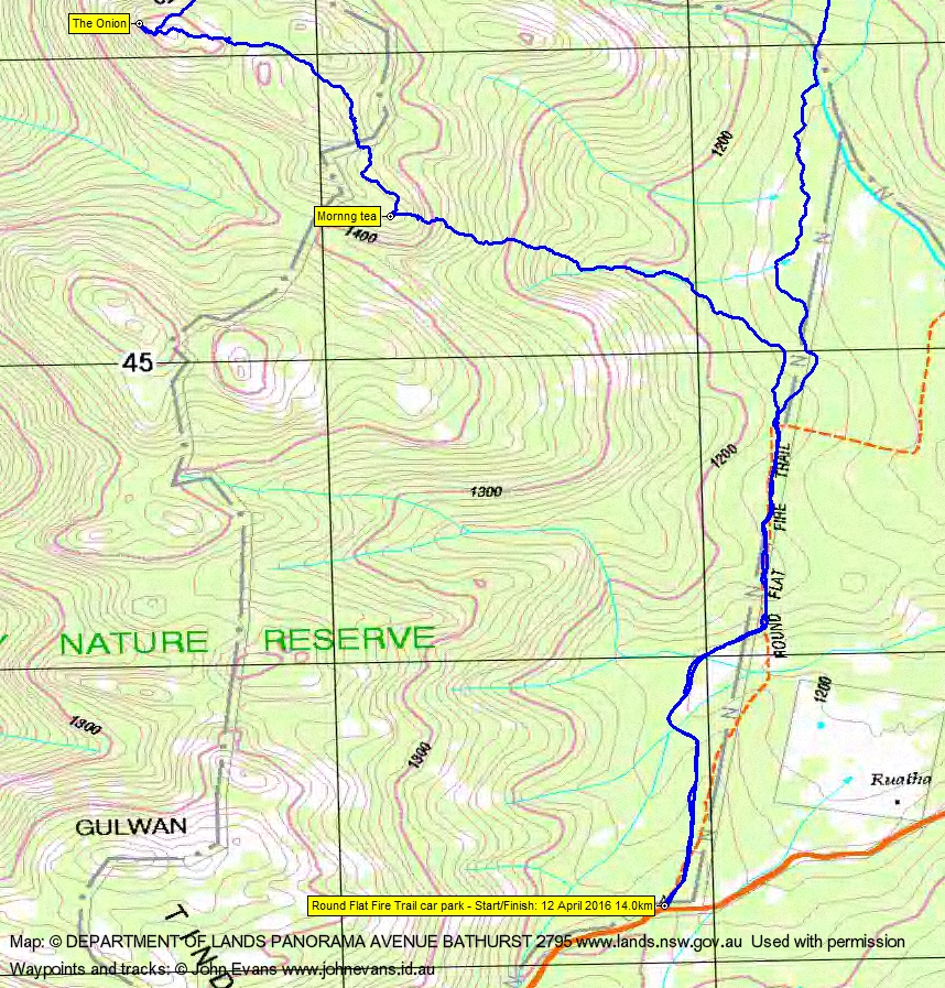
8 of us drove in 2 vehicles to the Round Flat car park on Tinderry Road.
Summary
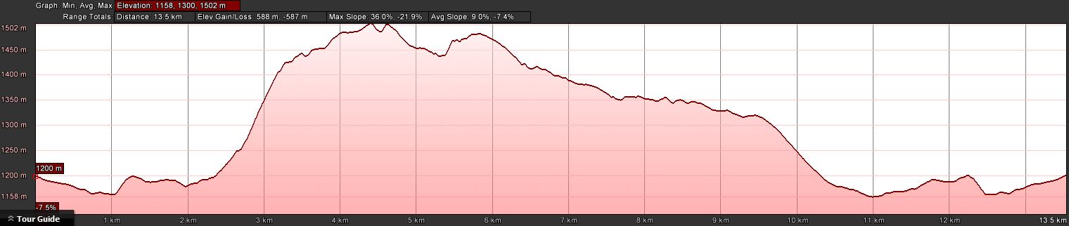
Distance: 14.0km | Climb: 585m | Time: 8.05am-4.25pm (8hrs 20mins), including 45 mins of breaks | Grading: L/R; H(12)
Photographs
Photographs are available, where you can start a large sized slideshow.
Videos
Waypoint and Track Files
Download the .gpx file. (Right click, Save Link As…, Save – if you want to use it.)
To use in Google Earth, do File, Open… and select Gps or All files as the File Type.
Track Notes
Ian relocated us from the top of Blue Gum Creek in Namadgi National Park, due to road closures for controlled burning. Always nice to walk in the Tinderrys.
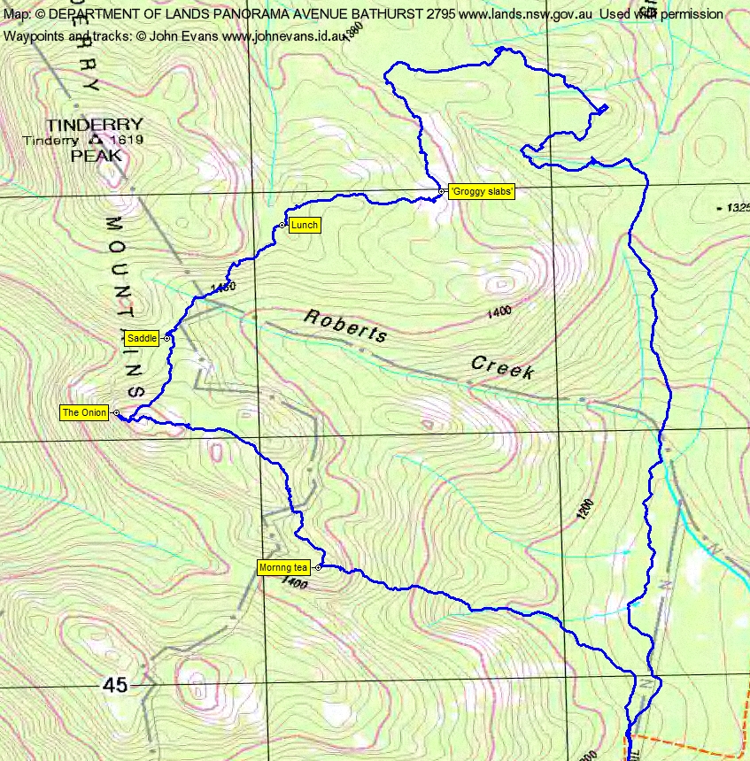
A walk in along the Round Flat fire trail, passing the northern limit of fire a couple of years ago. At the first elbow we headed off-track, climbing NW to morning tea. 270m vertical gain through forest and granite. More climbing took us to The Onion, with a little scramble across the granite to take in huge views from south through west to north. Check out the pics and video.
We came off to the NE, down through a saddle and crossed the top of Roberts Creek. Then a climb through forest and granite to lunch.
We trended east after lunch, to ‘Groggy slabs’, huge areas of granite above Groggy Creek.
Next north to cross a swampy area at the top of Groggy Creek, then a loop to visit more granite. Some lovely old growth forest in this area.
A long leg to the south with easier walking after crossing Roberts Creek got us back to the fire trail.
A full complement of 8 making a very cohesive party. A great round from Ian again
Track Maps
Track overview

Track 1
Track 2
Profile
Party
8 walkers – Melinda B, Eric G, Linda G, Ian H, Roger H, Lorraine T, Ian W (leader), me.
Next Tuesday Walk
Tuesday 19 April: Mt Pleasant and Kybeyan Gorge – M/R. A circuit with a view point, a granite gorge and fairly open ridges. Park on the Kybeyan West FT at approx. 121 E, 868 N (GDA94) and walk up to Mt Pleasant (1050 metres). Descend the ridge to the north to the Kybeyan River. Upstream, rock hopping, for about 3 km along the river past bluffs and large pools; the pools have brownish water like the Shoalhaven, then return via ridges to the cars. ~ 13 km, total ~ 530 m ups and downs. Road access crosses private property for which permission has been obtained. A 1hr 40 min drive from south Canberra. Leader: Linda G. Maps: Numerella, Kybeyan. Transport: $20 per person.
Guy Morrison
14 May , 2016 7:49 amThe only serious walk I’ve done in the Tinderrys is the day walk Tinderry Twin (or ‘north’ as I call it). Very straightforward and rewarding: Depart from Mt Allen and ascend directly and steeply up the Mt Allen Firetrail. Veer off the track when it turns sharp north directly west of the unnamed peak to the north of Tinderry Twin. The summit is clearly in sight here (nice pyramid dome thing) and it is a relatively short bush bash east and then south to the summit. Great if somewhat odd views when you get there. Nice granite and alpine vegetation with a throne like granite formation you can sit in.
Thanks for documenting all these walks John.