
Lunch views over the Tidbinbilla Nature Reserve
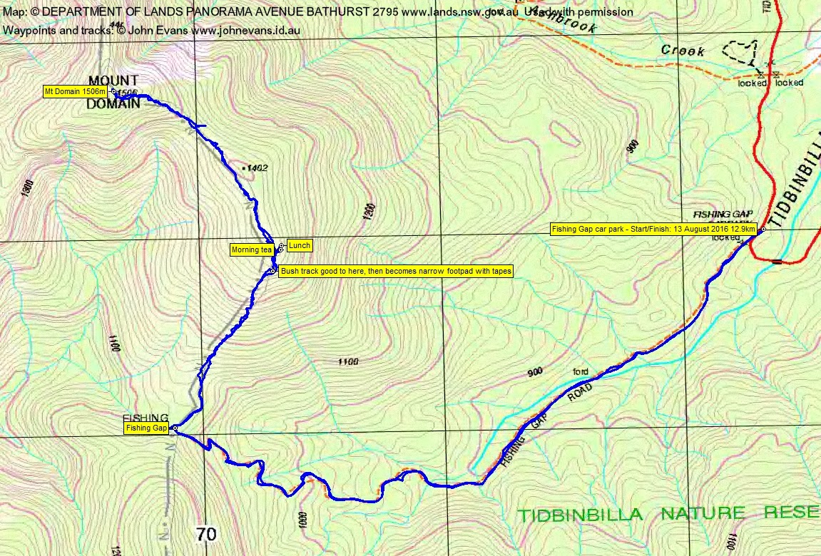
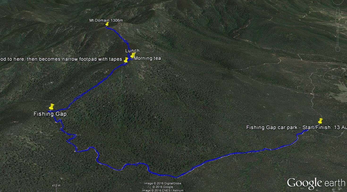
Saturday 13 August: Mt Domain – M/R. Link road, Fishing Gap fire trail to Fishing Gap then up the partly cut track to Mt Domain and return. Height ∼800m, distance ∼10 km. Map: Tidbinbilla. Leader: Jenny H. Transport: ∼$28 per vehicle.
8 of us met, 7 in Kambah and they picked me up at Lanyon opposite my old folks’ home.
Summary
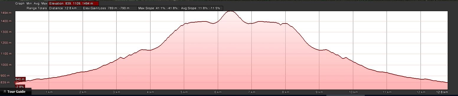
Distance: 12.9km | Climb: 675m (from contour difference; 790m from GPSr and Google Earth | Time: 8.50am – 2.40pm (5hrs 50mins), including 45 mins of breaks | Grading: M/R; M(11)
Photographs
Photographs are available, where you can start a large sized slideshow.
Video
Waypoint and Track Files
Download the .gpx file. (Right click, Save Link As…, Save – if you want to use it.)
To use in Google Earth, do File, Open… and select Gps or All files as the File Type.
Track Notes
Am I a Domain-ophile? – 4th trip this year. It’s interesting to see the route developing. Already the clearing done by the Green Army is softening. A lot easier to follow than in the snow of last time on 16 Jul 16. Another walker up there today, enjoying the new, easier route. I see that (as of today) there have been 5 other geocaching trips up there, and no doubt other private trips. I remain a huge supporter of this route. Perhaps my next trip up here will be a Fishing Gap-Mt Domain-Snowy Corner cairn-Lyrebird Trail round to augment the tapes that Rob H put up a little while after my initial taping trip.
So the standard trip on a day that gave us warm(ish) sun, a bit of cloud, a cool breeze. But delightful in the lee at morning tea and lunch. Check out the pics and video. Always the chance to send off a social media post from the summit, in the hope it might encourage others to get out and breathe a bit of fresh air.
A few in the party had not been up here, or not for a few years. Uru, on her first CBC walk, did a huge job in leading us along part of the SH1402 ridge and I was panting to keep up.
Views to the fabled Greens Peak (SH1409 NW of High Range and NE of Corin Dam) led to some gentle arm twisting and I’m sure we’ll see a walk there via Fishing Gap once in daylight savings to give us more time in TNR (won’t it T?). And views to ‘The Pyramid’ (SH1172 between Devils Gap and Stantons Gap on the SE side of TNR) will also see a CBC short-notice Tuesday Walk, won’t it TL? And some potential walks led by P after she completes the CBC Navigation Refresher course.
If you’re interested in a more technical description of the trip, see 16 Jul 16, 28 Mar 16 and 16 Mar 16. Other trips are listed under Mt Domain at ACT High Hills.
Thank you Jenny and all.
Track Maps
Party
8 walkers – Leanne A, Paula F, Jenny H (leader), Trevor L, Uru M, Terrylea R, Steven S, me.
Charlotte le Clerc
24 October , 2016 7:31 pmHi John
thanx so much for your posts about Mt Domain, and all the fabulous hard work done to create a new trail. Martin and I journeyed up here on Sunday (23/10/16) and had a wonderful time. Did manage to grab the lower and upper geocache, but not the drop-off… save one for next time.
I am so thankful that you allowed us ‘newbies’ to join the journey to Split Rock earlier this year, for without your encouragement, we would have been unlikely to venture ‘off-track’ as we have been doing recently.
Hope all is well with you and your family
Kind regards, maXine 🙂
Johnny Boy
26 October , 2016 8:02 pmHi Maxine
SO glad you are enjoying the bush. The Mt Domain route is a little over-cleared at the beginning, but it will soon grow over. Some don’t agree with the cleared and taped route, but I certainly do. Keep exploring off-track. Walk safe and carry a PLB.
Cheers. john