Mt Coree

Saturday 13 February: Mt Coree – L/E. All on fire trails from Blundells Flat. Around 18km and 700m climb. This will be a moderately paced walk taking us to the summit of Mt Coree which has excellent views on a clear day. Situated in the Brindabella National Park on the NSW side and in the Namadgi National Park on the ACT side, Mt Coree marks the point where the ACT border changes from a straight north-easterly line to following the watershed of the Cotter River. Before European settlement, the mountain was used by indigenous Australian tribes to hunt for bogong moths. Map: Cotter Dam. Leader: Cynthia C. Limit: 8. Transport: ∼$8 per person.
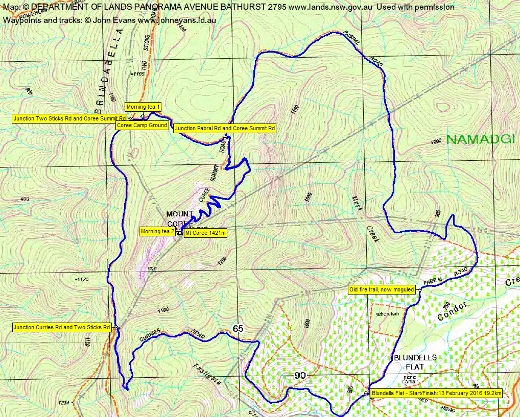
11 of us drove in 3 vehicles to park at the intersection of Curries Rd and Pabral Rd, just over the Condor Creek ford at Blundells Flat.
Summary
Distance: 19.2km | Climb: 930m (from Google Earth)/825m from GPSr | Time: 7.40am-12.45pm (5hrs 5mins), including 40 mins of breaks | Grading: L/E; M(11)
Photographs
Photographs are available, where you can start a large sized slideshow.
Video
Waypoint and Track Files
Download the .gpx file. (Right click, Save Link As…, Save – if you want to use it.)
To use in Google Earth, do File, Open… and select Gps or All files as the File Type.
Track Notes
With the temperature in Canberra forecast to be 32ºC, our leader wisely called a 7am meet and we were walking by 7.40am. Much chatting among new and old friends, even as we tackled the almost 300m rise of Curries Rd. I found a partner in crime in Tahnia, to push ahead to the top then come back down to meet the ascending party. Supposed extra Cbr100Challenge training. Lovely in the shade.
Turning south along Two Sticks Road we also had shade. A pair of yellow-tailed black cockatoos in the trees at the junction with Pabral Road.
A nice stop in the Coree Camp Ground (unaccompanied by any 4WDers, as were there on 8 Jun 13) for morning tea. There is a loo opposite.
Then another push east along Pabral Rd then up the Coree Summit Road, with Paul hard on my heels. Rock climbers at the bluff just below the summit.
From the top it was a bit hazy east towards Canberra, but the view west over Flea Creek and Webbs Ridge and beyond was clear and spectacular. A zillion 4WD (well, 4 or 5) vehicles pulled up and occupants jumped out for the view. Morning tea #2 called (Max S take note – 2 morning teas whereas you gave us none last Monday).
We left at 10.10am and came back via Pabral Road to the NE then S, past the arboretum site. The blackberries beside the road were delicious. It was starting to warm up.
And so back in town for other things of the day.
Another great walk by this popular leader, thanks Cynth. Wait for her next one! Thanks all.
Track
Track
Profile

Party
11 walkers – Mike B, Cynthia C (leader), Tahnia L, Stephen and Lisa M, Julie M, Kim McI, Paul and Karen O, David W, me.
Next Tuesday Walk
Tuesday 16 February: Ridge West of Bushfold Flats, Namadgi National Park – L/R/ part X. From the Booroomba Rocks car park we will follow the Alpine Track for 2 km then head off-track to the north to investigate the rocky knoll west of Bushfold Flats. We will visit a number of steep bluffs and granite outcrops before descending steeply to Blue Gum Creek and following tracks for 8 km back to the cars. This is a hard walk in very steep and scrubby terrain with some rock scrambling. Minimum distance: 14 km with 600 metres of ascent. Map: Williamsdale, Corin Dam. Leader: Ian W. Transport: 100 km return. Limit: 8.