Source of the Murrumbidgee River

Tuesday 13 January: Source of the Murrumbidgee – S/M. A 10 km return walk mostly on Peppercorn Firetrail to the source of the Murrumbidgee River. A small bit of scrub bashing near the source so bring your gaiters. A short walk but a long drive to Long Plain north of Kiandra. Map: Peppercorn 1:25000 Leader: Mike B. Transport: $175 per car. Book: by 3 pm Sun 11 Jan. Limit: 8.
6 of us drove in 2 cars via Cooma, Adaminaby and Long Plain Rd to park near the intersection with the Peppercorn Fire Trail. Around 3 and a half hours each way, including a stop at Adaminaby.
Summary
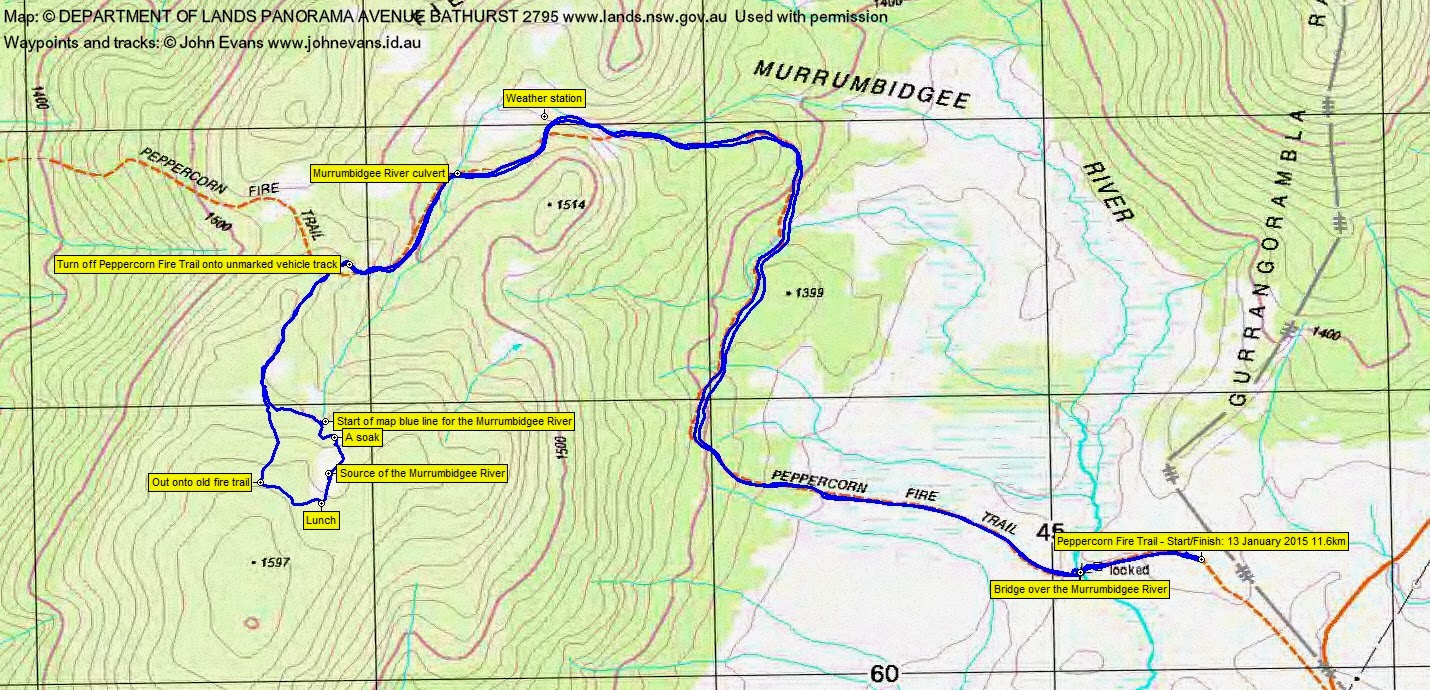
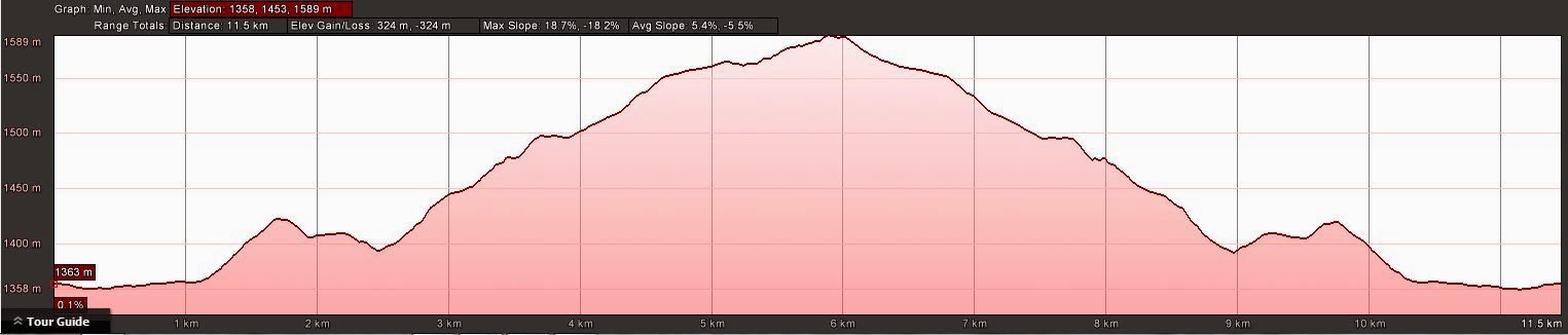
Distance: 11.6km | Climb: 330m | Time: 9.55am-1.35pm (3hrs 40mins), with 25 mins of breaks | Grading: M/E-M; M(9-)
Track Map
Track
Profile
Photographs
Photographs are available, where you can start a large sized slideshow.
Video
gpx File
Download the .gpx file here. (Right click, Save Link As…, Save – if you want to use it.)
kml File
Download the .kml file here.
Track Notes
What better way to start a walk than with a geocache! I ran along the car park, down and forded the mighty Tuggeranong Creek concrete channel and found and logged GC42VR6 Seurat It Up.
We piled into 2 4WDs and I was whisked in air conditioned sleeping comfort for a sausage roll and sauce and coffee at Adaminaby. Back to dozing as we passed through Kiandra and up the Long Plain Road to park just in along the Peppercorn Fire Trail.
The day was overcast and needed a light extra layer at first.
We were immediately into the wildflowers and green grassy Long Plain as we followed the fire trail down across the Murrumbidgee River wooden bridge. A couple of brumbies across in the edge of the trees. Into the tree line and the very pleasant ramble continued. We were passed by a contractor’s vehicle, catching them at the weather station where they were doing maintenance.
A further kilometre on we popped on gaiters and left the Peppercorn Fire Trail onto an unmarked old vehicle track (although marked on Mike’s Rooftop map). The Peppercorn FT leg was 4.5km in an easy 1hr 5mins.
Around 620m along this, we headed bush to the start of the blue line of the Murrumbidgee River on the map, at GR 55H FA 42859-60938 (MGA). Many huge patches of blackberries and a little sphagnum moss. Peter consulted his aerial photos on his phone and spied an open area a little further ‘upstream’, so we set off initially through the blackberries then thankfully via brumby track. We first came to a soak, a little damaged by horses’ hooves, then into the more open area where we declared another soak to be the source of the Murrumbidgee River, at GR 55H FA 42863-60752 (MGA). As we wandered up to the top of the open area and a log for lunch there was much esoteric discussion as to what constitutes the ‘source’ of a watercourse.
A very pleasant lunch near tall Snow Gums and an obvious brumby ‘camp’, with wildflowers galore.
We exited generally West and Mike soon had us back on the old vehicle track. Just a matter of reversing out, except there was again much discussion concerning the definition of culverts and bridges.
A very light shower as we came out of the tree line.
Peter left us at Kiandra and drove into Selwyn, to head for a couple of days around Tabletop.
Larger mobs of brumbies spotted by some on the way back, but I was asleep again.
What better way to finish a walk than with a geocache! A quick find and log of GC120JB Big Fish at Adaminaby on the way back. More snoozing followed.
Although ∼7 hours of driving for a short walk, this was a cameo little trip. Beautiful grassy country with masses of wildflowers and an iconic site. Huge thanks Mike
Party
6 walkers – Mike B (leader), Peter C, Eric G, Stewart J, Max S, me.
Next Tuesday Walk
Tuesday 20 January: Finish the Cbr100Challenge 50km route – L/E. Not your usual Tuesday walk. Meet on Red Hill and walk Melbourne Ave, Parliament House, Commonwealth Ave bridge, north side of lake to Glen Loch interchange, Arboretum, Scrivener Dam, Curtin, Deakin and back to the start. Around 28km at a brisk pace. Surely there will be coffee somewhere. Map: Canberra. Leader: John Evans 0417 436 877 john@johnevans.id.au . Transport: Drive yourself, but please contact me if you need a lift and I’ll try to assist. Late bookings considered.