The going 1km south of lunch

Wednesday 13 May: Cookbundoon Nature Reserve – M/R/X. The reserve was gazetted in 2010 and is located 15 km northeast of Goulburn. It is an area of about 7 km x 1.5 km, with steep gullies and ridges of native forests and woodlands. The area is new to the leader and will be on fire trails and off-track. There is a 1 hour 30 minute drive each way. Minimum distance: 15km with 500 metres ascent. Maps: Towrang, Chatsbury 1:25,000. Leader: Ian W. Transport: 270 km return. Limit: 8.
4 of us drove via Goulburn, Towrang and the Tarlo River Rd to park. Around 1hr 30mins each way.
Further Information
Nature Reserve Statement of Management Intent here; Fire Management Strategy with map here.
Summary
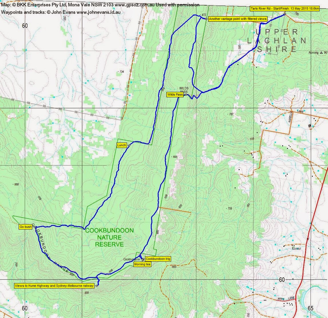
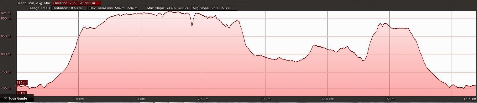
Distance: 18.6km | Climb: 585m | Time: 8.35am-2.10pm (5hrs 35mins), with 40 mins of breaks | Grading: L/M; M(11)
Track Maps
Track overview
Track 1
Track 2
Profile
Photographs
Photographs are available, where you can start a large sized slide show.
Waypoint and Track Files
Download the .gpx file here. (Right click, Save Link As…, Save – if you want to use it.)
Download the .kml file here.
Track Notes
Ian did it again, sussing out yet another new area for us to explore.
A good drive, all on sealed road apart from about 2km of very good dirt on the Tarlo River Rd.
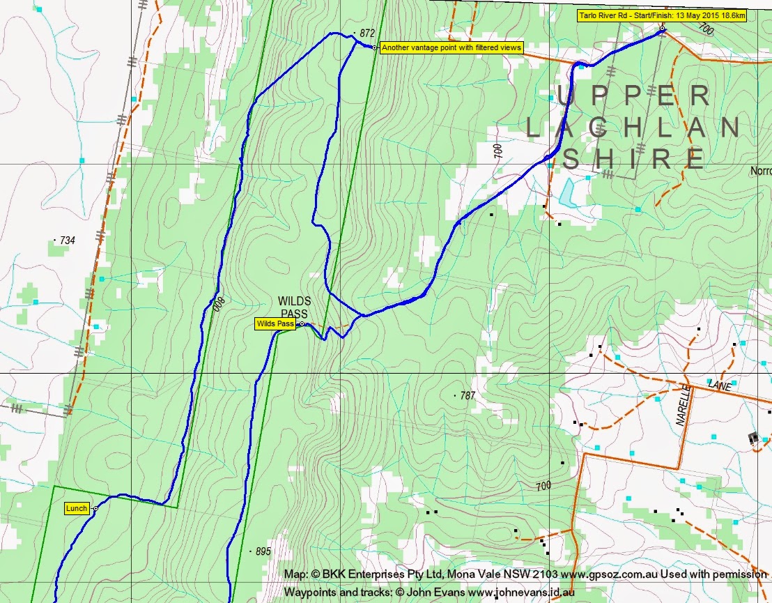
A cool day (I had on 5 layers, long johns, beanie and gloves) as we walked up the fire trail to Wilds Pass. Then south along the crest on the fire trail to call in to Cookbundoon trig for morning tea. 5.9km in 1hr 20mins.
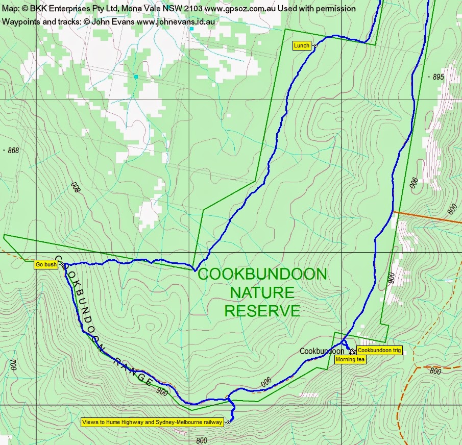
A delightful short detour off the fire trail through open forest with grasses under to the grand cairn and trig. Great views down to the south-east.
Back on the fire trail we continued to round out the southern extent of the walk, including another detour to a further vantage point, from which we could see the Hume Highway and watched a long train trundle by. From morning tea to going bush was 3km and 40mins.
A new area is always worth a look, but we were getting a bit sick of the fire trail. So it was nice to go off-track. And even nicer to discover what we had to walk through. A gentle 100m descent through generally open woodland to the western edge of the Nature Reserve, lots of Casuarinas. The edge of the NR, near the cleared grazing land, was pretty flat and open. It made for very enjoyable and quick walking, a pleasure on an eXploratory walk. The leg from leaving the crest to lunch was 2.7km in 1hr. We even found some gratis old vehicle track, softened through disuse.
After lunch we continued north along the NR border and soon got on more old track (it did happen to be on the west side of the border fence). Again, very pleasant and easy walking, although we were still pretty well rugged up. Some rocky bluffs started to appear above us as we neared the point determined for us to regain the crest. This leg from lunch 2.4km in 40mins.
I have no idea why my GPSr stopped tracking on the climb, except that I may have scared it by removing a few layers for the climb. This leg had its interest too as we traversed up across the rocky slope. We eventually gained the crest near SH872.
Here we found the crest-top fire trail. This (and many other fire trails in the NR) is not marked on either the LPI topographic map or our OZraster digital maps, but the Fire Management Strategy with map here shows several of the other tracks. Along with a detour to a third vantage point, we followed the fire trails back to the car. This final leg 3.9km in 50mins.
The NR is certainly well worth a visit and, with the multitude of tracks, provides many options for shorter walks. The western edge is the pick of it.
Driving back, we turned north onto the Hume Highway then east off it to a VC rest area where Ian H showed us the Towrang Stockade site. Most interesting.
And to cap it off, we drove into a localised storm which dropped the outside temperature to 4°C and whitened the hills above Lake George with hail.
Party
4 walkers – Eric G, Ian H, Ian W (leader), me.
Next Tuesday Walk
Tuesday 19 May: Parliament Hill, Blue Mountains National Park – L/R/X. The walk starts at the junction of the Little River fire-trail and the Jerong Road, 34 km northeast of Taralga. This is a new area for the leader. We will follow the fire-trail north for 6 km then head off-track for the day. We will climb Parliament Hill and explore the woodlands and forests in the catchments of Parliament Creek and Cunninghams Creek. This is a long day, with numerous ascents and descents. There is a 2 hour 35 minute drive each way. Minimum distance: 16 km with approx. 850 metres of ascent. Map: Mount Armstrong. Leader: Ian W. Transport: 371 km return Limit: 8.
Linda Groom
14 May , 2015 8:53 amLooks like nice country
Johnny Boy
14 May , 2015 9:33 amYes, except for the fire trail bash … which could be shortened. I think Ian’s considering a return to the northern part of the NR, down to the Tarlo River.