Bramina Creek cascades from the south side of the creek

Saturday 13 May: Honeysuckle Trail to Brindabella Valley – L/E,X. When driving the Mt Franklin Rd, have you seen the gate at the top of the Honeysuckle Trail south of Bendora Hill? There’s a track which descends 700m down a spur to the Goodradigbee River in the Brindabella Valley. Let’s walk down it … then back up. Around 14km and 700m climb. Maps: Tidbinbilla and Brindabella. Leader: John Evans 0417 436 877 john@johnevans.id.au . Transport: ∼$15 per person.
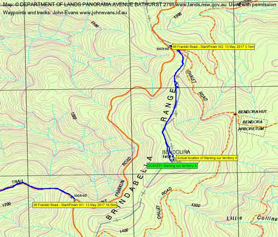
While down in the Brindabella valley, possibly another 4km round trip to GC38F5N Brindabella 5 and GC6GQ6Q Brindabella’s Bramina. Nab GC4XZ0Y Marking our territory 4 if time and energy allow.
Further Information
My companions were such great walkers and enamoured of geocaching that we did both extensions to the walk.
Summary
Distance: 16.5+3.1km | Climb: 810+200m | Time: 8.30am – 1.20pm (4hrs 50mins), including 20 mins of breaks + 1.50 – 3.00pm (1hr 10mins) | Grading: L/E,ptX; H(12-)
Photographs
Photographs are available, where you can start a large sized slideshow.
Waypoint and Track Files
Download the .gpx file. (Right click, Save Link As…, Save – if you want to use it.)
To use in Google Earth, do File, Open… and select Gps or All files as the File Type.
Track Notes
Walk 1
If you promise not to tell anyone about this walk, I’ll share the trip report with you. If you tell, my sorry reputation will be in tatters. It was a pretty boring walk. What brought me here was that, apart from Harrys Spur from Mt Ginini, I’d never walked down the west side of the Brindabellas. I think that’s what brought my companions here too, especially when there were 2 other weekend trips on the CBC walks program and a beaut day walk tomorrow, as well as (as I learned on the walk), an NPA trip to Mt Gudgenby today. Jared, a first time visitor, had the misfortune to contact me two days ago for information about the Canberra Bushwalking Club and I convinced him to join us today.
The Mt Franklin Road at the top of the Honeysuckle Trail provided a spot to park right by the gate. 1hr to drive from Cooleman Court Weston and to shake out ready to walk.
We set off down the trail. It is very well maintained and, apart from the gradient in places, a very easy (if boring) walk. A little cloudy but quite mild with no breeze. A lyrebird flapped and glided down the trail in front of us, perhaps a portent of better things to come. Nothing came. We walked the 6.5km down the Honeysuckle Trail to meet the Brindabella Valley Road in 1hr 25mins, dropping 700 vertical metres.
Here things did change a little. This is a very pretty area. We crossed the Brindabella Valley Road to the grassy bank of the Goodradigbee River, here running flat and quietly. We followed the river downstream through grazing cattle.
My excitement rose as we reached the bridge, heading for the first geocache. Now, I am a poor cache finder and, as often happens on my trips with geocaching options, others find the caches for me. Here, Jared obliged and I logged GC38F5N Brindabella 5. We sat under the bridge and enjoyed morning tea. A lovely part of the river, here dropping a little and flowing noisily over rocks.
We next headed up Brindabella Road above a gorge containing the Goodradigbee River, towards a bridge crossing Bramina Creek. Another gurgling drop downstream from the bridge with a couple of cascades. Indecision as to which side of the creek the cache was. My GPSr maps were showing just on the true left side, so we went down there. Discovered that the cache was on the other side, but were rewarded by lovely views of the creek as we walked back up to the bridge. Back over the bridge onto the correct side, down a short fence line that was the hint for the cache. Thank goodness Jared followed me down and made the find whilst I was faffing around. Logged GC6GQ6Q Brindabella’s Bramina.
We walked back to the bottom of the Honeysuckle Trail, passing fly fishermen on the Goodradigbee.
So the dreaded climb began and slow and steady got us up. Not too bad, only 35mins slower at 2hrs than the descent for the 6.5km. A relaxed (short, of course) and well deserved lunch by the car.
Walk 2
We drove to the turn in for the Bendora Arboretum and parked. 3 of us wandered up to Bendora Hill, 1.6km and 200m climb in 35mins. There is a vegetated old vehicle track which provides a route up. There are a couple of patches of rampant regrowth covering it and a few places where the direction is only indicated by the gap in the trees. But a pleasant stroll and nice to be in the bush and off the fire trail.
Thanks to a number of recent logs of the cache on the hill, the correct location is known. Unfortunately the cache owner published a location 34m away from the actual location. This is a common trait of all of the Marking your territory caches that I have done. Anita was introduced to the pleasures of ACT border markers. A find, by Stephen, and a log by me of GC4XZ0Y Marking our territory 4.
Back down the hill and a drive home.
And what was the best part of the day for me (apart from a walk where I’d never been before, the lovely Goodradigbee River, the fabulous Bramina Creek and three geocaches) – a loan of the book The Complete Idiot’s Guide to Geocaching!
Thanks for your company friends.
Track Maps


Party
4 walkers – Anita D, Jared H, Stephen M, me.
Anita Davis
14 May , 2017 5:01 amThanks John for the geocaching initiation. Hopefully not tempted…
Johnny Boy
14 May , 2017 9:26 amWhat about border markers then? 🙂