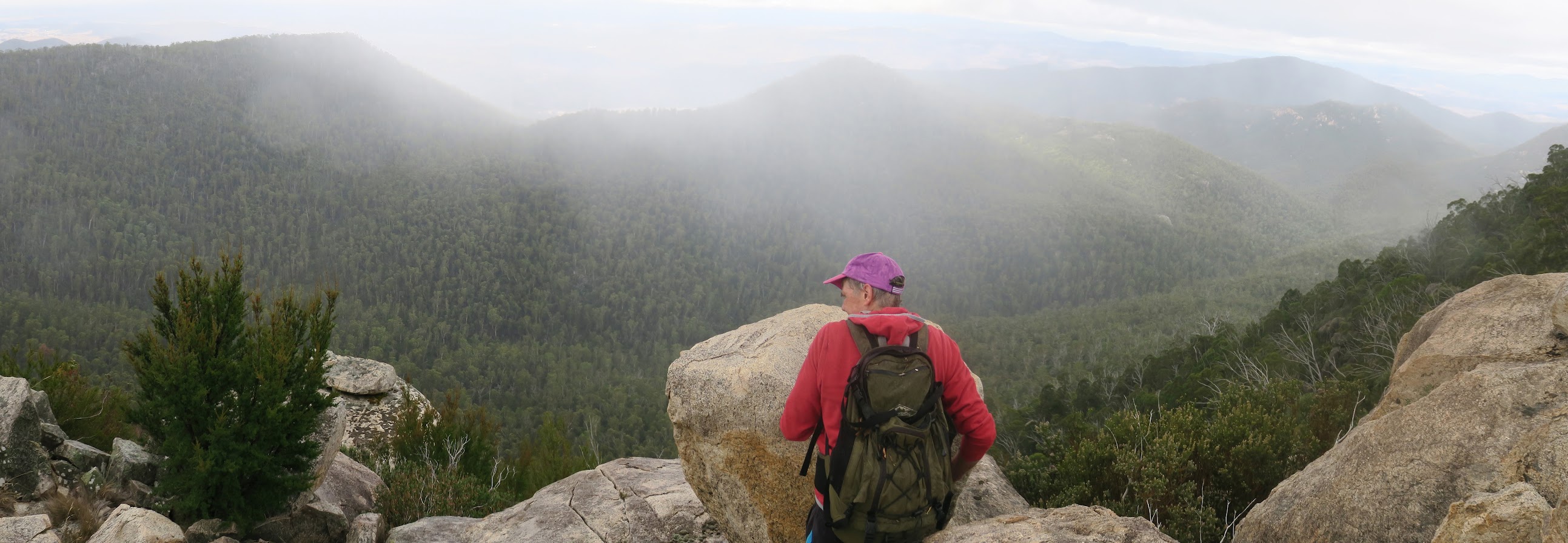
Roger near our main objective at Blue Gum Hill
Tuesday 14 March: Blue Gum Hill Cliffs – L/R. Above Blue Gum creek are some nice granite slabs with two geocaches hidden amongst the rocks. Possibly scrubby along the tops. Distance about 16 kilometres, ascent about 600 metres. Map: Corin Dam. Leader: Roger E. Transport: ∼$20.00 per car. Limit: 8.
Further Information
My last trips here 23 Oct 04 and 5 Sep 06.
Summary
Distance: 15.6km | Climb: 750m | Time: 8.05am – 5.00pm (8hrs 55mins), including 55 mins of breaks | Grading: L/R; H(13)
Photographs
Photographs are available, where you can start a large sized slideshow.
Video
Waypoint and Track Files
Download the .gpx file. (Right click, Save Link As…, Save – if you want to use it.)
To use in Google Earth, do File, Open… and select Gps or All files as the File Type.
Track Notes
Rating just below a “Well done, good and faithful servant” at the Pearly Gates would have to be a tough geocaching trip through wild Namadgi scrub with great friends. We got that today! And walking in the rain for the first time in yonks.
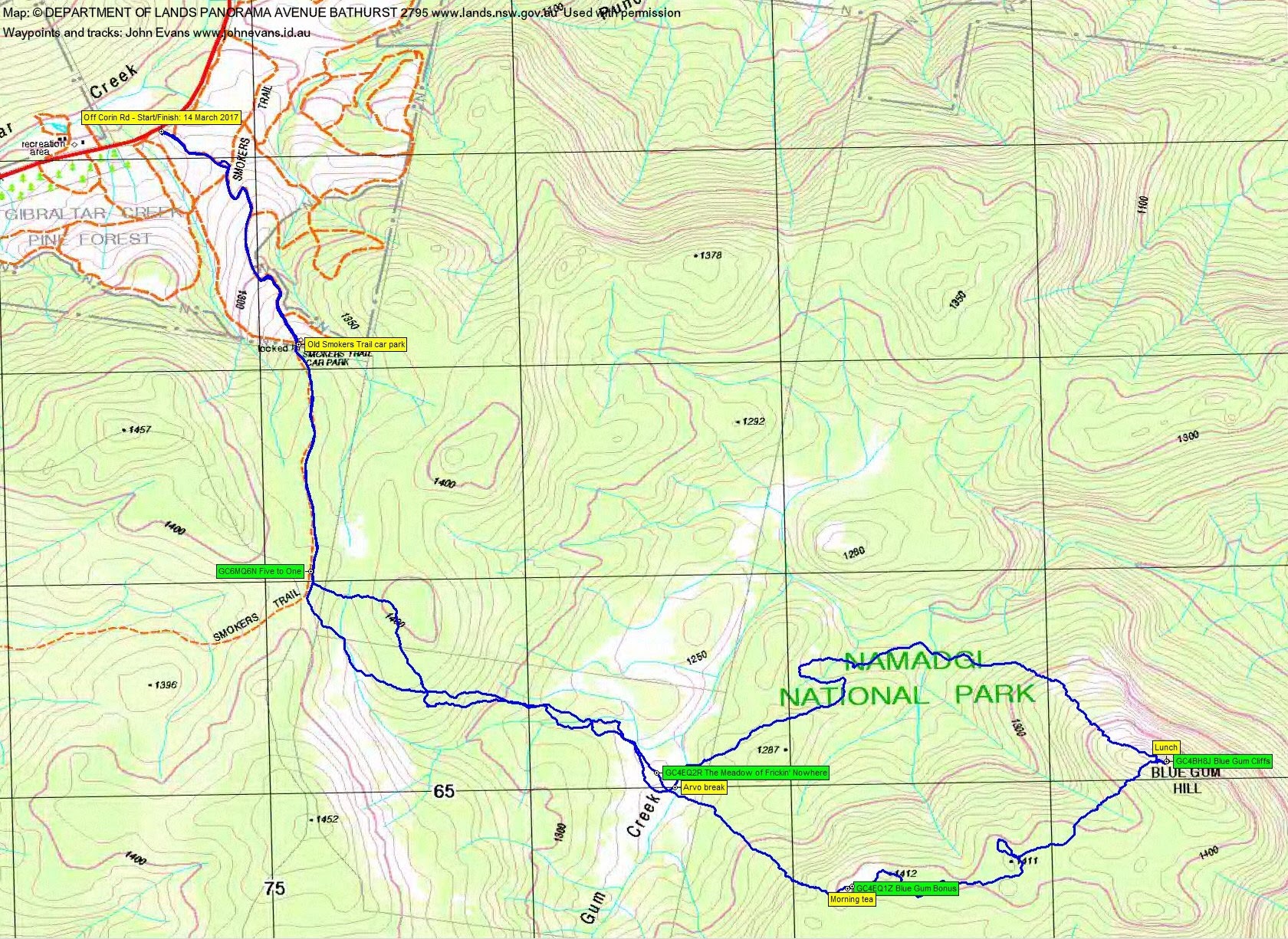
An insert from the ‘gravel pit area’ beside Corin Road to join the fire trail up to the old Smokers Trail car park. Then a jaunt along Smokers Trail for me to log Marmaduke Rothschild’s GC6MQ6N Five to One.
Back across the other side of the road we headed down through mild scrub to the open flats of Blue Gum Creek for me to log GC4EQ2R The Meadow of Frickin’ Nowhere. Thanks for finding it Mike.
Further to the SW and up 150m took us to morning tea and a find of GC4EQ1Z Blue Gum Bonus.
Then began a very scrubby climb to Blue Gum Hill. Maybe we shouldn’t have cut the corner, but down, across and up the other side of the creek line made for interesting going. 1hr 30mins for 2km. The showers caught us, so it was coats on for the rest of the day. Many of us remarked that it had been a long time since we’d walked in the rain.
GC4BH8J Blue Gum Cliffs was duly found with the help of the spoiler pics and logged. Huge views across Blue Gum Creek far below into southern Canberra. Two wedge-tailed eagles soared effortlessly below and above us.
Roger’s plan for our homeward leg was anything but retracing our steps. We left at 12.45pm and the NW exit from Blue Gum Hill provided initially rocky and easy going. But we were soon back down in the regrowth. Our less than graceful arc from lunch back to arvo break on Blue Gum Creek was 3km in 2hrs 15mins.
One last patch of scrub and regrowth amused us around the 1400m knoll east of where we regained Smokers Trail. My fault as I was (poorly) navigating.
Back down Smokers Trail and fire trails to the car where we all agreed (a) that we were well exercised and (b) we would never go back.
Thanks Roger and all.
Track Map
Party
6 walkers – Mike B, Roger E (leader), Meredith H, Robert M, Ian W, me.
Next Tuesday’s Walk
The Fortress, Namadgi National Park – L/R/ptX. From the Yankee Hat carpark we’ll follow Bogong Creek for a few kilometres then head northwest, ascending 700 metres to the Scabby Range and the ACT border. The Fortress is the unofficial name for a prominent knoll 2.5 kilometres northwest of Mount Gudgenby. The return route will be close to the morning route. Most of the day is off-track in steep terrain, with difficult scrubby going in places. 7.5 kilometres of the walk is on fire-trails. Bookings by the Friday night before. Minimum distance: 18 km with 890 metres of ascent Maps: Rendezvous Creek, Yaouk. Leader: Ian W. Transport: 110 km return. Limit: 8.