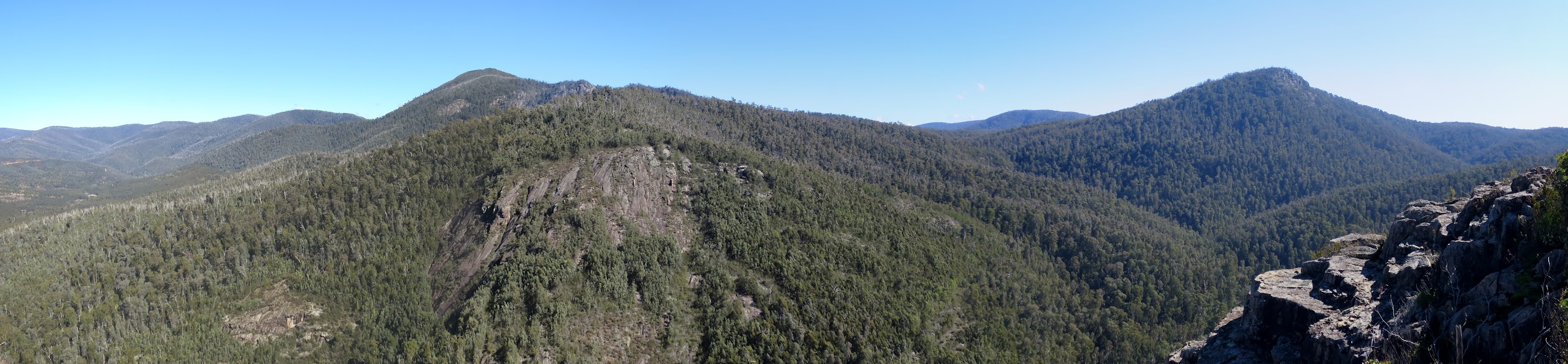
Mt Coree, the other side of Coree Creek and Devils Peak from the 80r cliffs
Tuesday 16 August: Cliffs West of Mt Blundell – L/M-R. A walk mainly along fire trails. From Mt Blundell however we will be scrub bashing down to a rocky cliff line (80 metre drop) that overlooks Coree Creek. This trip is designed for those interested in geocaches that are located in remote and areas of difficult access. About 700 metres of climbing up some steep and slippery fire trails. And about 18 kilometres of walking. Not suitable for beginners. Map: Cotter Dam. Leader: Roger E. Transport: approx $20.00 per car. Limit: 8.
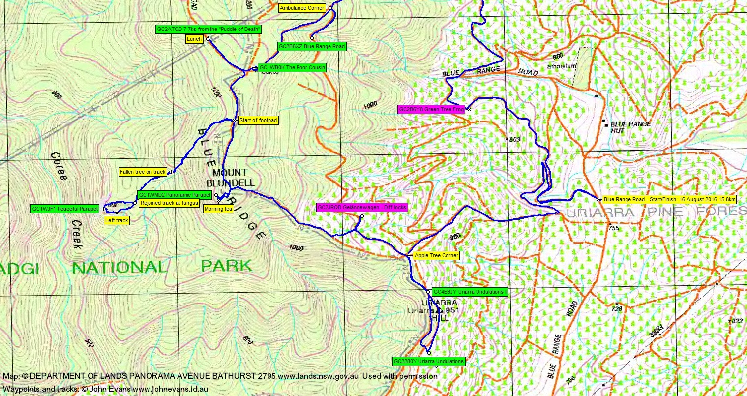
4 of us met in Weston and drove via the Cotter, Brindabella Rd and Blue Range Rd to park on the side of the road at a convenient ‘up’ fire trail.
Summary
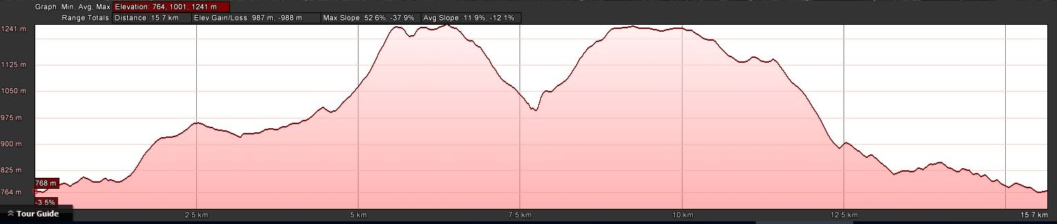
Distance: 15.8km | Climb: 980m | Time: 8.00am – 2.20pm (6hrs 20mins), including 35 mins of breaks | Grading: L/M; H(13)
Photographs
Photographs are available, where you can start a large sized slideshow.
Video
Waypoint and Track Files
Download the .gpx file. (Right click, Save Link As…, Save – if you want to use it.)
To use in Google Earth, do File, Open… and select Gps target=”_blank”or All files as the File Type.
Track Notes
A beautiful Canberra winter’s day. Blue sky, a bit of breeze on the tops, ∼14ºC in town.
We parked on the side of Blue Range Rd and climbed the 200 vertical metres via wiggly fire trail then disused and moguled fire trail to Apple Tree Corner. Some recent logging of the pines near the top. The 2.5km took 45mins.
Then a loop around Uriarra Hill to find and log GC4EBJY Uriarra Undulations II and GC2280Y Uriarra Undulations.
Back at Apple Tree Corner we took Blue Range Rd for a bit to the location of GC2JRQD Geländewagen – Diff locks. A DNF, as the cache area had been vandalised by forestry operations.
We backed out a bit, then up through the scrub to the crest fire trail, the boundary between the forestry area and Namadgi National Park. A grueling climb from 950m to Mt Blundell at 1220m.
Here we headed a few tens of metres south-west along a fire trail not marked on the 1:25000 Cotter Dam map (but it is on the Cotter Dam OZraster map I have). (This old trail actually heads south down a steep spur, then west to join Pabral Rd.) Then through a dense band of shrubs to come out onto a cleared are with huge views across Coree Creek and up the Mt Coree and Devils Peak. Very breezy and cool. We found and logged GC1WMD2 Panoramic Parapet, then popped south over a crest to get out of the wind for morning tea. Great views down to the south-west across Blundells Flat.
Our exit from the area was a fraction south and a whole lot more elegant than the entry. Back on the crest vehicle track we headed north for a bit until we came to the start of a route to the next cache (that start location is available via the geocache).
I was last here on 18 Nov 08. On that occasion we came up from Pabral Rd and exited down Coree Creek. This time a caching acquaintance not only reminded me of the location associated with the cache, but also gave me his track. Very handy, but not necessary. This is a beautiful little well defined footpad that gets one very close to the cache. We had to leave it when we neared the cache; it probably heads down to Coree Creek. Anyone know who put it in? Anyway, we got to the top of the 80r cliff and found geocache GC1WJF1 Peaceful Parapet. More fantastic views across Coree Creek to the cliffs on the other side. These two ‘parapet’ locations are fabulous places for the views – pity there is such a fire trail climb to get to them.
Again, our exit (a little to the north) was more elegant than our entry and we climbed back the 200 vertical metres up the footpad to the crest old vehicle track.
From here a bit north to join Blue Range Rd and along it to the ACT-NSW border and Namadgi National Park/Brindabella National Park boundary. Roger made a quick find of GC2ATQD 7.7ks from the “Puddle of Death”. We lunched on the other side of the road.
Back to the intersection, again Roger made a quick find of the nearby GC1WB0K The Poor Cousin. Didn’t quite understand what all the stuff in the cache description was supposed to mean.
Then north-east on Blue Range Rd to Ambulance Corner and south-west to log geocache GC2B6XZ Blue Range Road.
Returning to Ambulance Corner, we took the map-marked, but now disused and moguled fire trail 250 vertical metres down. More pleasant (at least for me) than going up in the morning. Then south to rejoin Blue Range Rd and another look for GC2B6Y8 Green Tree Frog, which we hadn’t found on 5 Apr 16. This time Roger found the green tree frog on the ground, but no cache. Can we register a 1/2 find?
Back to the car.
On the way home we had a look for a cache at the Cotter, but no joy. No joy at the Cotter bridge, either. A cop turned us round as there had been a bad motorbike accident, so we had to come home via Uriarra Crossing.
Great day thanks Roger and Eric and Phillip.
Track Map
Party
4 walkers – Roger E (leader), Eric G, Phillip S, me.