Mt Domain

Saturday 16 July: Fishing Gap to Mt Domain and return – M/R,X. Walk up the Fishing Gap fire trail and then follow the newly taped foot pad to Mt Domain. Return the same way. About 12km and 700 m climb. Map: Tidbinbilla. Leader: Phillip S. Transport: $7-$9 pp, plus entry fees (if applicable). Limit: 8 people. Booking: Please book by email before 2 pm Thursday 14 July.
9 of us drove in 2 vehicles to the Fishing Gap car park in Tidbinbilla Nature Reserve.
Summary
Distance: 13.2km | Climb: 830m | Time: 8.50am – 2.40pm (5hrs 50mins), including 35 mins of breaks | Grading: L/R; H(12)
Photographs
Photographs are available, where you can start a large sized slideshow.
Videos
Waypoint and Track Files
Download the .gpx file. (Right click, Save Link As…, Save – if you want to use it.)
To use in Google Earth, do File, Open… and select Gps or All files as the File Type.
Track Notes
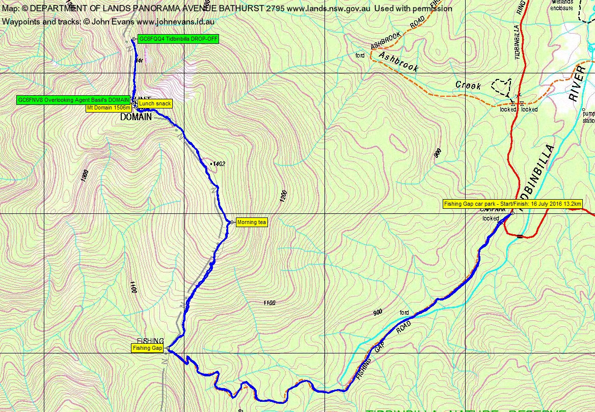
We began by strolling up to Fishing Gap, 3.7km in 52mins. A mini morning tea was had.
Eventually 7 of us set off up the highway towards Mt Domain. I was interested to see the route clearing work that was done, as I’d heard that the beginning of the route was perhaps a little overdone. True, but I’m sure the scrub will grow back and within a year or two it will just be a footpad route. We soon hit a little snow, very pretty on this blue-sky, perfect Canberra winter’s day. I’ve overdone the photos of the route, just as a record for me. The 250m climb from Fishing Gap at 1130m to morning tea at 1380m and 1.1km took 50mins. A few more of my tapes (hung on 16 Mar 16 at the request of TNR Rangers) were left up as the route closed in as we approached the SH1402 ridge.
Morning tea was called at the southern end of the ridge, with sun and a view down into TNR. I called an opinion poll of the walkers as to their views on the route so far. As I expected, there were opposed views to the clearing of the route. Happily, this spread of opinion will both secure our wilderness areas and also open them up to others (I hope). Personally, I’m very supportive, as I’m all for people getting out and enjoying this part of TNR and enjoying the views. The route did close in a bit later, so it would be a persistent lot of new people who would come up here. A self-limiting route. And the route clearing/taping doesn’t really detract from navigational challenges – once you’re on the spur, the only thing to do is stay on the crest.
The SH1402 ridge consists of a length of relatively open heath-land and some close Tindinbilla Ridge regrowth. It eventually comes out onto a very shallow and cleared saddle before the final climb to Mt Domain.
The final climb is up a rocky spur, then through more open forest. A shallow snow covering all the way today. We hit the Mt Domain cairn at 11.45am. So the trip from Fishing Gap to Mt Domain is 2.4km and took 1hr 50mins (including 15mins morning tea, so 1hr 35mins walking). A 375m climb from 1130m to 1506m.
We moved past the cairn a few tens of metres to a more open view. I had the smell of a geocache and Roger and I made a quick find of GC6FNV8 Overlooking Agent Basil’s DOMAIN.
Lunch was called and, with the leader’s nod to a pre-arranged sortie, Roger and I sacrificed that time to head a further 460m north along the ridge to find and log geocache GC6FQQ4 Tidbinbilla DROP-OFF. Striking views from the razor ridge here, to the east down over Tinbinbilla Nature Reserve and west down over the Cotter River and up to the Brindabellas. Truly magnificent! Back with the party by 12.35pm where Phillip allowed us a quick drink before we set off home.
A simple reverse out. From Mt Domain to Fishing Gap, the 2.4km in 1hr 12mins. Fishing Gap to the cars 3.7km in 45mins.
Hats off to our gentlemanly and gallant leader who managed to keep the party together when there were desires for the opposite; at least the splinter groups were in pairs and PLB equipped. IMHO splitting a group does not lead to adventure, but is more likely to be the precursor for misadventure.
Thanks Phillip and all. A truly lovely day!
I applaud the TNR head ranger who initiated this project. As the route beds in (and the scrub regrows), I believe it will reform a footpad allowing the Tidbinbilla Range traverse from Fishing Gap to Camels Hump that existed prior to the 2003 fires.
Track Map
Track
Profile

Party
9 walkers – Mike B, Peter C, Roger E, Eric G, Frank McK, Meg McK, Barrie R, Phillip S (leader), me.