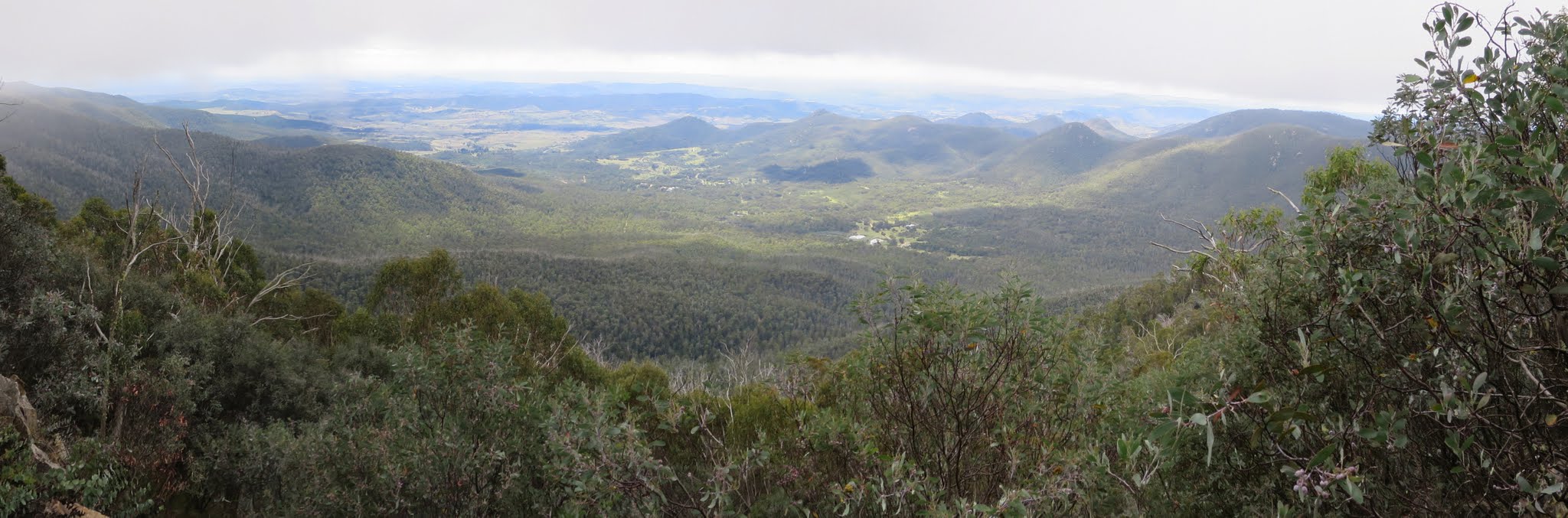
Tidbinbilla Valley from tape 014
Wednesday 16 March: Mt Domain – M/R. Become a TNR volunteer for the day! Walk from Fishing Gap to Mt Domain. Around 12km and 670m climb. Map: Tidbinbilla. Leader: John Evans john@johnevans.id.au 0417 436 877. Transport: ∼$8. Limit: 8.
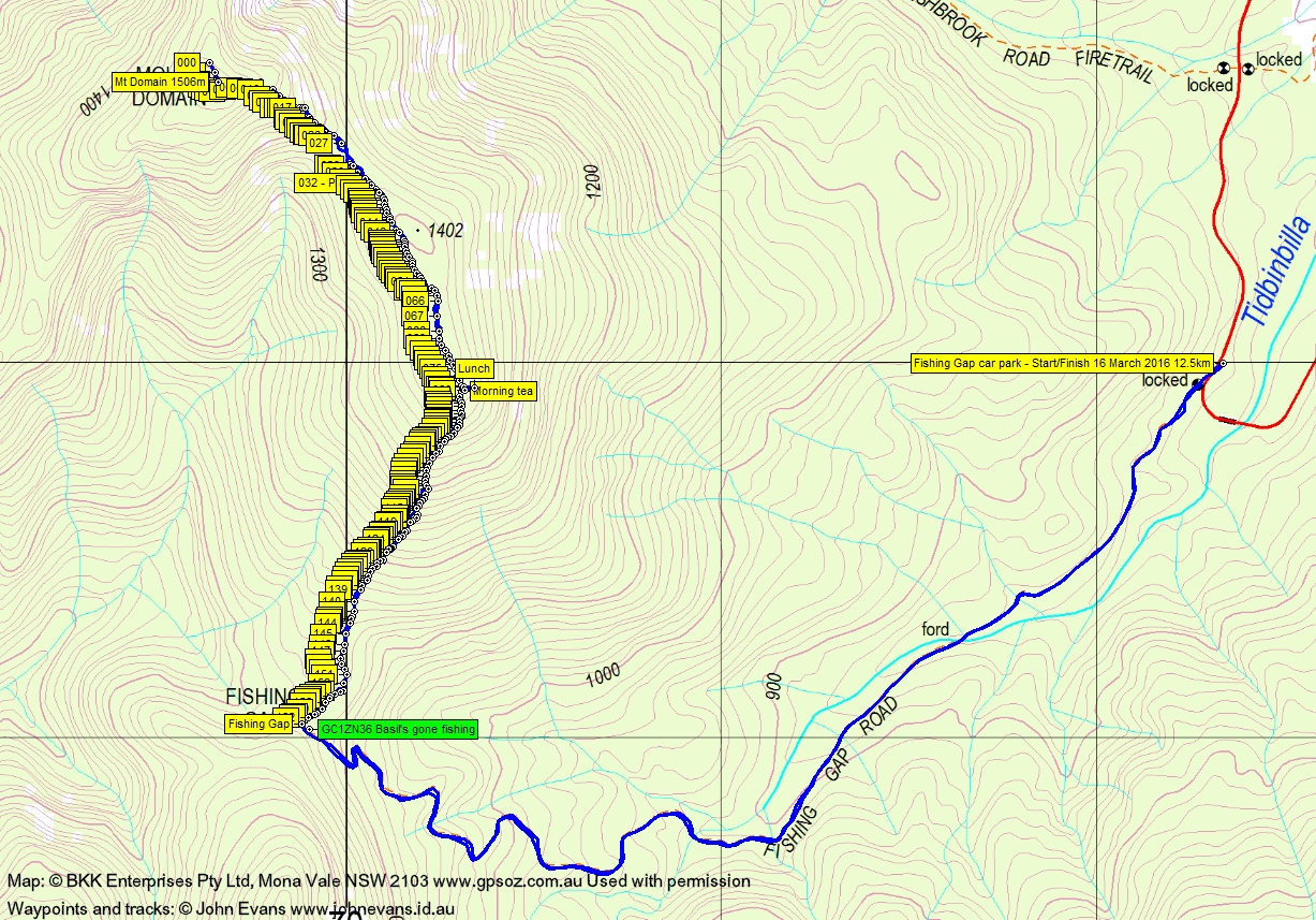
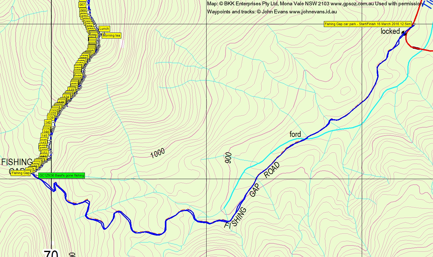
6 of us drove in 2 vehicles to the Fishing Gap car park in TNR.
Further Information
The objective of this trip was to tape a route (with the blessing – but not the company, at the last moment – of TNR Rangers) from Fishing Gap to Mt Domain. As I understand it, the desire is to tape a route from Fishing Gap to Camels Hump and hope that a footpad is eventually worn in. This may attract more active walkers to the Tidbinbilla Range crest and provide a catching feature to prevent walkers straying off the west side of the Range. The route will not be formally advertised nor maintained.
Summary
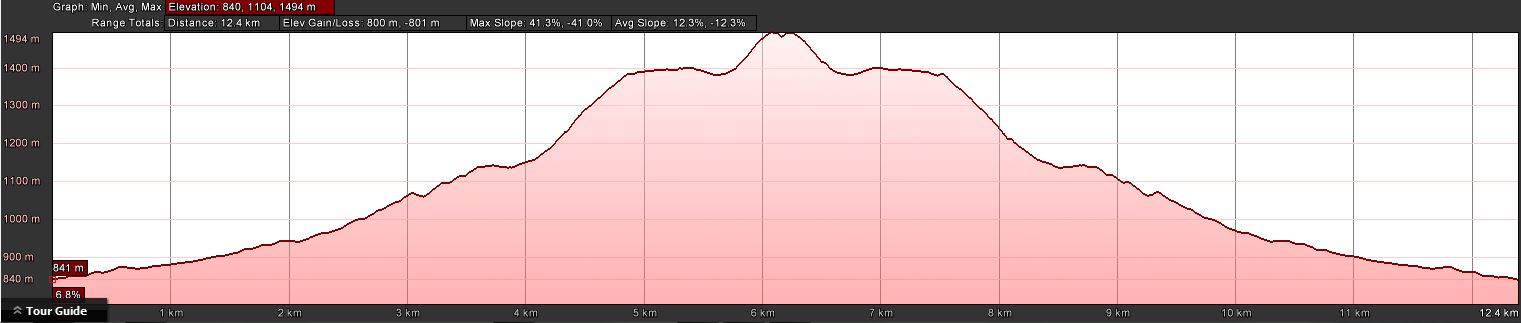
Distance: 12.5km | Climb: 800m climb (GE)/740m climb (GPSr)/685m (contour differential) | Time: 8.15am-2.35pm (6hrs 20mins), including 50 mins of breaks | Grading: M/R; H(13)
Photographs
Photographs are available, where you can start a large sized slideshow.
Waypoint and Track Files
Download the .gpx file. (Right click, Save Link As…, Save – if you want to use it.)
To use in Google Earth, do File, Open… and select Gps or All files as the File Type.
Track Notes
A bit of a misty morning and the day didn’t clear until after we’d left Mt Domain. So few views.
We began with a stroll up the Fishing Gap fire trail, covering the 3.7km in 50mins. Monster Canberra geocacher mtbikeroz was in the party, so gave me large clues to find and log GC1ZN36 Basil’s gone fishing.
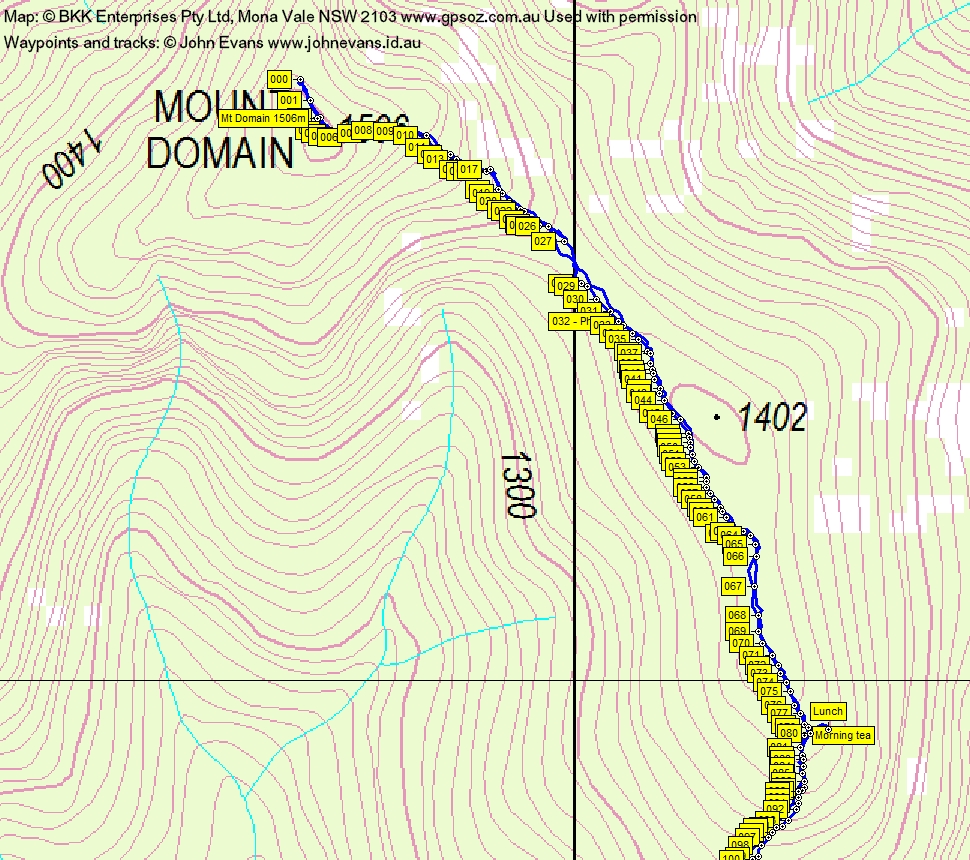
The idea was to tape the route which generally follows the crest of the spur up to Mt Domain. I originally thought that we could place around 15 tapes, as the Rangers didn’t want it made too easy. However, I was easily convinced by Ian’s sound argument that, if they want a footpad worn in, the route needs to be able to be followed. That needs tapes point to point visible. I had two rolls of orange tape and in the end we hung 163 tapes.
We shook out and worked as a team. I hopefully knew where we were to go, so took the lead and placed a length of tape where necessary. Others behind tied the tape and also added others where the gap was too large. Ian marked the locations on his GPSr.
A bit of a gasp up the first climb to the ridge that contains SH1402. It was airless and muggy. But the going was relatively easy with only one really bad patch where a better line could have been taken. We pulled up for morning tea at the beginning of the ridge.
The ridge alternated wattle regrowth, a few open patches and a large area of heath. An open area in the long saddle at the bottom of the second and final climb to Mt Domain, maybe cleared as a rough helipad.
A nice rocky spine goes part of the way up the final climb to Domain, some tight regrowth and a few open leads. In general, the whole route is quite pleasant, with grasses underfoot in all but the rocky spots.
We topped the Mt Domain cairn at 11.25am. No view. We continued on north for another 60m to where I knew one looked down to further north along the Tidbinbilla skyline. Nothing seen today. Placed the northern most tape, Tape 000 and did an about turn.
The plan going back was to see if we could follow the taped route! David H did an excellent job out front. Next came Ian with GPSr guided corrections where necessary. When these were required, other party members hung additional tapes. I brought up the rear, which gave me the opportunity to take a few photos and to waypoint all the tapes. Ian’s tape waypoint on the way up and mine on the way down had reasonable correlation (within GPSr accuracy of up to 10m). There was only one place where we had to faff around a bit at a rock outcrop with tight scrub nearby.
The sun appeared as we descended and there were a couple of decent views.
Going up took 2hrs 17mins for 2.5km from Fishing Gap to Mt Domain (including morning tea) and the descent took 2hrs 25mins.
Many thanks to party members for joining in the spirit of the day.
I reckon the next trip could be up from the Lyrebird Track via the razor spur to the Snowy Corner cairn, then tape south to Mt Domain, as in 28 Aug 12.
Track Maps
Track overview
Track 1
Track 2

Track 3
Track Fishing Gap to Mt Domain
Profile
Party
6 walkers – Riddhi B, David and Meredith H, David L, Ian W, me.
Next Tuesday Walk
Tuesday 22 March: Parliament Hill, Blue Mountains National Park – L/R/X. The walk starts at the junction of the Little River fire-trail and the Jerong Road, 34 km northeast of Taralga. This is a new area for the leader. We will follow the fire-trail north for 6 km then head off-track for the day. We will climb Parliament Hill and explore the woodlands and forests in the catchments of Parliament Creek and Conninghams Creek. This is a long day, with numerous ascents and descents. There is a 2 hour 35 minute drive each way. Minimum distance: 16 km with 850 metres of ascent. Map: Mount Armstrong. Leader: Ian W. Transport: 371 km return. Limit: 8.
Geoff Puleston
17 March , 2016 4:11 amFantastic account John, congratulations on doing this fine work.
You’re the modern-day Harry Mouat!
cheers
Johnny Boy
17 March , 2016 9:39 amHi Geoff. They were tough lads back then. Today we’re nowhere near them. Can only hope that a few parties will do the trip to start defining the footpad. Perhaps my geocaching friends could place a cache on Domain – that would get some more people up there! Cheers. john
Sean Sunley
19 March , 2016 6:49 pmJohn,
Went out today on the route, just enough tapes. We had to turn around at the lunch spot as we were short of time. Looking forward to the Tidbinbilla Traverse.
Sean
PS My mobile phone is out there somewhere if you find one!
Johnny Boy
19 March , 2016 7:36 pmHi Sean. Thanks for doing the route. Sorry about your phone. My ($5) sunnies up there too. The 2 treasures might attract some other walkers! Cheers. john
Guy Morrison
11 May , 2016 8:25 amI’ve been eye-ing off Mt Domain with interest since I was a teenager in the 1970s when we climbed Tidbinbilla Peak (and many other walks), so I’ve been interested to read that John Evans and co. having been climbing these more (ahem) obscure hills in the ACT mountains. Well done – the Mt Domain – Mt Tidbinbilla traverse you did several years ago deserves a BBC documentary…!
I’ll try to persuade the people I walk with to try this, though they are very reluctant to leave established tracks. Otherwise I’ll have to join the Canberra bushwalkers.