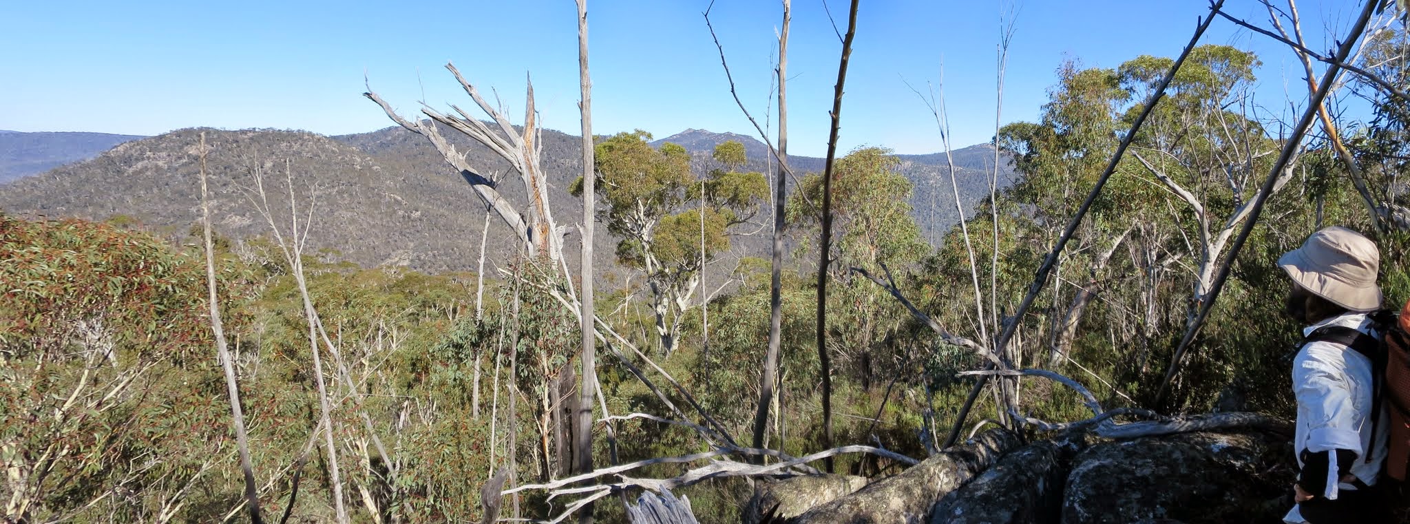
View to Yankee Hat North and South, Mt Gudgenby and The Fortress from 1420m contour on the lower Mavis Ridge
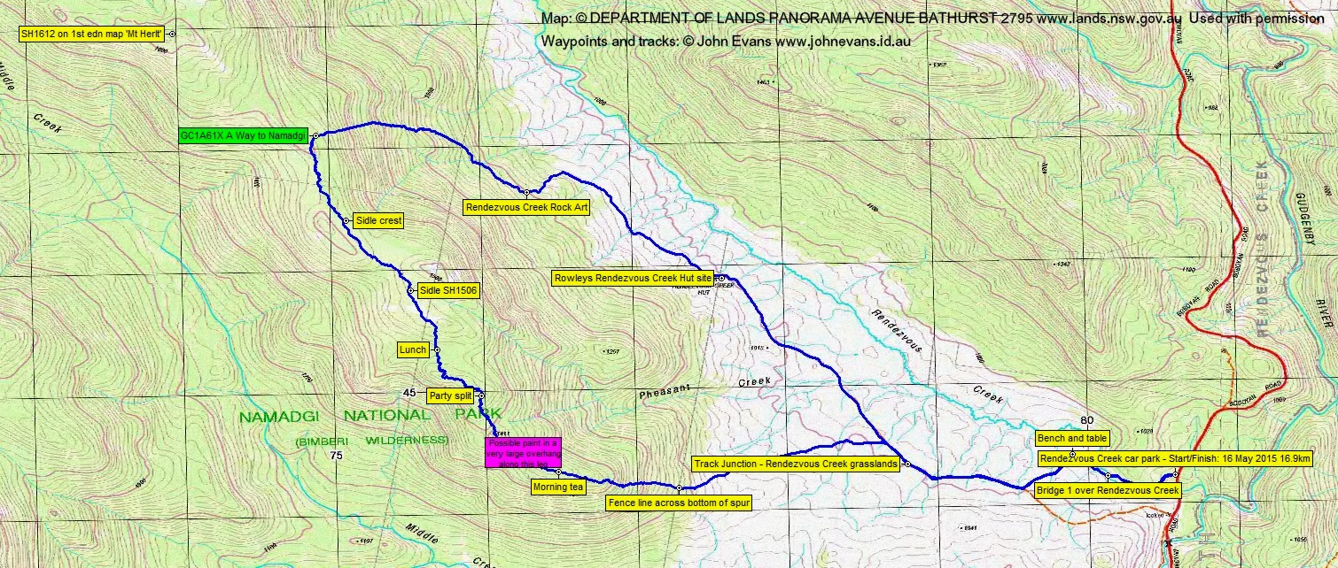
Saturday 16 May: Pheasant Creek–Mt Herlt – M/R. From the Boboyan Road near Rendezvous Creek the route crosses open ground to climb the ridge forming Pheasants Creek then along through scrub to the rock outcrops of Mt Herlt. Descent is directly into Rendezvous Creek. Map: Rendezvous Creek. Leaders: Jenny & Rob H. Transport: $40 per vehicle.
12 of us drove in 3 vehicles to the Rendezvous Creek Walk car park.
Further Information
A chance to grab Geocache GC1A61X A Way to Namadgi.
Summary
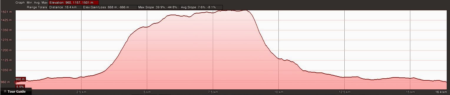
Distance: 16.9km | Climb: 670m | Time: 8.25am-5.25pm (9hrs), with 35 mins of breaks | Grading: L/R,ptX; H(13)
Track Maps
Track overview
Track 1
Track 2

Profile
Photographs
Photographs are available, where you can start a large sized slideshow.
Waypoint and Track Files
Download the .gpx file here. (Right click, Save Link As…, Save – if you want to use it.)
Download the .kml file here.
Track Notes
I last walked the lower Mavis Ridge on 14 Aug 07, so I knew it would be a very hard day.
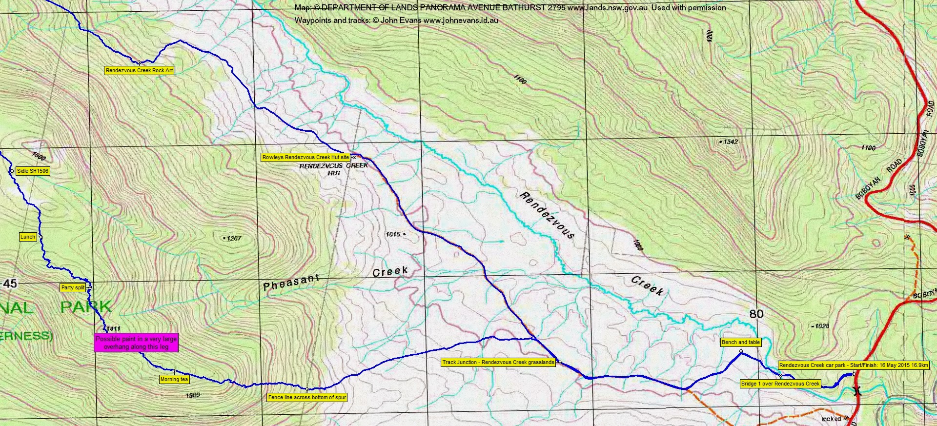
We left the Rendezvous Creek Walk car park and followed the track over the lower bridge and up to the rude (as in hand-crafted) bench and table. From there, along the mown path to join the old Rendezvous Creek vehicle track and NW along it for a few hundred metres to a suitable jump off point. This leg 2.3km in 30mins.
We then headed grid West to the fence line in the trees at the bottom of the lower Mavis Ridge, just South of Pheasant Creek. This leg 1.5km in 30mins.
The sky was blue and the air crisp when we left Canberra, but nearing the track-head the cloud came down and the air was still crisp. However, the cloud lifted as we began our climb and it was a beautiful sunny, windless day for the rest of our outing. We soon stripped off beanies and replaced with hats, and removed a layer or two. Slow going as we climbed the 250m to morning tea, hitting some areas of pick-up-sticks. Nice views opened up behind us, down to the Rendezvous Creek valley. Morning tea was called at 10.30am and the climb leg to here was 1km in 1hr.
Slow going as we continued NW along the crest of the ridge towards SH1411. But an interesting feature in a huge overhang. Great shelter, but no water. More pick-up-sticks. At around the 1420m contour we had great views to the SW to Yankee Hats North and South, Mt Gudgenby and ‘The Fortress’.
At midday Rob stopped the party. We were still 5.3 crowlometers (that’s km as the crow flies) from Mt Herlt and we’d just done 1.1km in 1hr 15mins. It was obvious that we wouldn’t reach Mt Herlt today, so Rob very kindly suggested that the party split to give me an opportunity to at least reach the geocache. So Llewellyn (geocacher Black Lotus Eater) and Jamie decided to come with me and I was very grateful. I would not walk this country alone.
Rob and Jenny and the others returned down via Pheasant Creek.
The going was hellishly horrible as we pressed on. To make it even more difficult our line was directly into the sun. It took 55mins to do 790m to lunch and I was going as fast as I could. 15mins for munchies.
I’d set a bug out time of 2pm in my head, but as that time approached and we were within 660 crowmetres of the cache, we pressed on. Me a little too keen and took a tumble to head-butt some granite. Again, dense scrub with some pick-up-sticks and an occasional short run of rocks or heath in the saddles. The leg from lunch to the cache was 2.3km in 1hr 30mins and we reached it at 2.45pm.
A quick find and log – objective achieved!, a quick drink and, as someone had logged, the best way back was straight down.
A little easier exit from the crest, mainly because it was down and no pick-up-sticks. A couple of little drops. But I did want to visit the Rendezvous Creek rock art, so we bent towards that as we descended. Again, no idea why the occasions of no track point recording – perhaps I knock my GPSr somehow. This leg 1.8km in 1hr 20mins, a bit slow but I think we were getting tired (I know I was).
A cursory glance at the rock art, then back to the car, arriving just on dark at 5.25pm. This leg 6km in 1hr 20mins.
Huge thanks to Rob for suggesting the split and to Llewellyn and Jamie for the company.
Note to self – never go back up there!
Party
12/3 walkers – David D, Dave D, Jen & Rob H (leaders), Ron K, Julie M, Jonathan M, Rhonda S, Stuart S; Llewellyn S-P, Jamie S, me.
Linda Groom
17 May , 2015 4:59 pmSounds like an epic! But in retrospect, sometimes it’s the epics that you remember most fondly!
Johnny Boy
17 May , 2015 5:06 pmAgreed, but I’m still not going back there (… till the next time)