… the most inhospitable and unrelenting country I’ve walked in a while
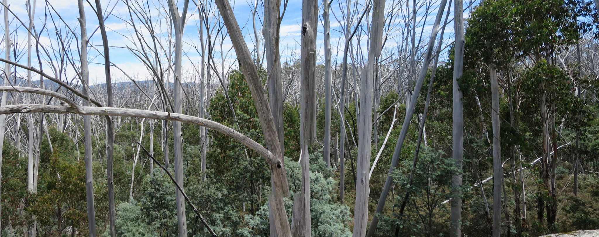
Dead Alpine Ash as far as the eye can see
Sunday 17 January: Peak 1409 – M/R. A challenging walk cross country and through scrub to the lovely shale peak in between Tidbinbilla and the Brindabellas. Participants should not object to scrub. More details will be available from the leader for interested participants. Map: Corin Dam. Leader: David D. Transport: $40 per car. Book by Friday 15 January.
6 of us drove in 2 vehicles up Corin Road to the new Square Rock car park, where the road is currently gated off.
Further Information
SH1409 used to be known as Greens Peak. There’s a fabulous tale in Matthew Higgins’ wonderful book Rugged Beyond Imagination, ISBN 9781876944742(pbk.) You should have a copy of this! Anyway, on page 81 Matthew recounts that, around 1900, George Green was told that some of his lost cattle were on this rugged hill. Skilled riding by George and his brother brought the cattle back to the cleared Tidbinbilla valley. The vegetation must have been different then, but the land-form unchanged.
Summary
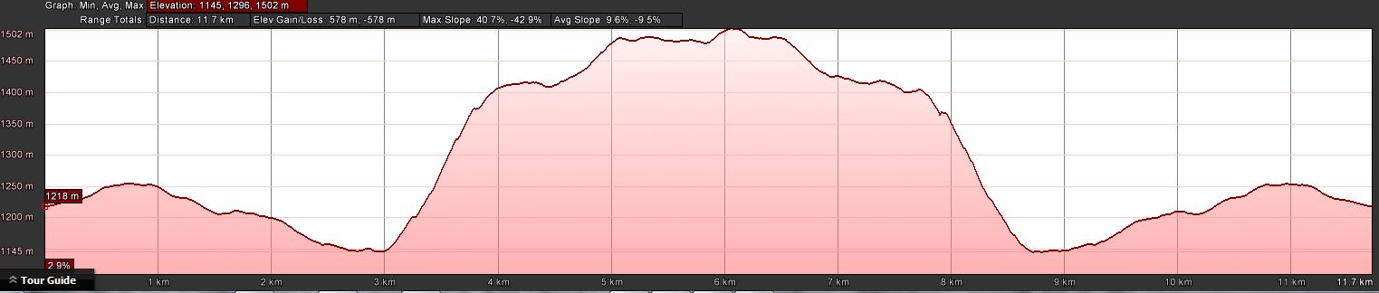
Distance: 12.2km | Climb: 580m | Time: 8.45am-6.00pm (9hrs 15mins), including 70 mins of breaks | Grading: M/R; H(12)
Photographs
Photographs are available, where you can start a large sized slideshow.
Videos
Waypoint and Track Files
Download the .gpx file. (Right click, Save Link As…, Save – if you want to use it.)
To use in Google Earth, do File, Open… and select Gps or All files as the File Type.
Track Notes
I should have been safely in church this Sunday morning, but instead the lure of a Percy had me shouldering my pack at the new Square Rock car park. We’d visited this area on a ‘grueling granite and rigorous regrowth‘ trip on 27 Aug 13, so I also knew what to expect.
Corin Road is currently closed (forecast to be reopened early 2016) due to work on Corin Dam, so we began (and ended) with a stroll down (puff up) the road for 3km to a suitable jump off point. Gaiters on, we gazed up at the steep flank of High Range, grey with dead Mountain Ash from the 2003 firestorms. Today was the day before the 13th anniversary of the burning. There was no way but up (after a little down to cross Kangaroo Creek).
After around 35 minutes of climbing one of our party needed to retire, so Phillip, the consummate gentleman and always seeking the best for party members and the party as a whole, returned with them. This allowed the remaining 4 to continue. Thank you Phillip.
The pea regrowth was as unrelenting as the climb. We’d turn around at each stop and enjoy the view back across to Square Rock. SH1412 marked the end of the climb onto High Range and the climb leveled out whilst the regrowth became more dense.
The area is vegetated primarily by burnt Alpine Ash. Many tree falls provided aerial highways well above ground level and gave brief relief from the constant scrub-bashing. As we climbed, the Daviesia gave way to Oxylobium, another ‘pea’ but a little harsher on the bare knees. David was certainly earning his keep/reaping the rewards of his walk in the lead – I reckon it takes another 20% of energy to force the path. But he was a man with a mission and he drove us hard, reluctantly calling morning tea at 11.45am.
It was pretty clear that SH1409 would not be reached today, but David pushed ahead towards a couple of knolls to the north-west. An intermediary small cluster of rocks allowed us a bit of a view and options were reconsidered. I took a couple of videos.
The 1500m knoll was spied and David decided to head for that. This was on the original planned route to SH1409. Thankfully the going was a bit quicker as we passed through patches of wattle regrowth with no pea. Nice views to the Tidbinbilla ridge from the 1500m knoll.
It was only 1.10pm! and, still not satisfied, David spied another knoll to the north-east. We bashed over to it, mutinied and lunch was called at 1.40pm. Signal, so a tweet and phone home.
A leisurely lunch and we turned for home at 2.15pm. Generally south-east and down all the way, but the regrowth was just as dense. We had an afternoon break near SH1412.
Then the plunge down off High Range, eased somewhat by the views across to Square Rock. At last down to Kangaroo Creek where we all enjoyed a sip of cool water.
The road bash completed the day.
Great trip, David. Great company too. But I will go to church next Sunday 🙂 .
Timings
| From | To | Distance | Time |
| Start | Leave Corin Rd | 3.0km | 40mins |
| Leave Corin Rd | SH1412 | 1.5km | 1hr 50mins |
| SH1412 | Morning tea | 0.4km | 30mins |
| Morning tea | ‘video rocks’ | 0.5km | 35mins |
| ‘video rocks’ | 1500m knoll | 0.5km | 30mins |
| 1500m knoll | Lunch | 0.5km | 30mins |
| Lunch | Break | 1.3km | 1hr 15mins |
| Break | Regain Corin Rd | 1.6km | 1hr 40mins |
| Regain Corin Rd | Finish | 2.9km | 32mins |
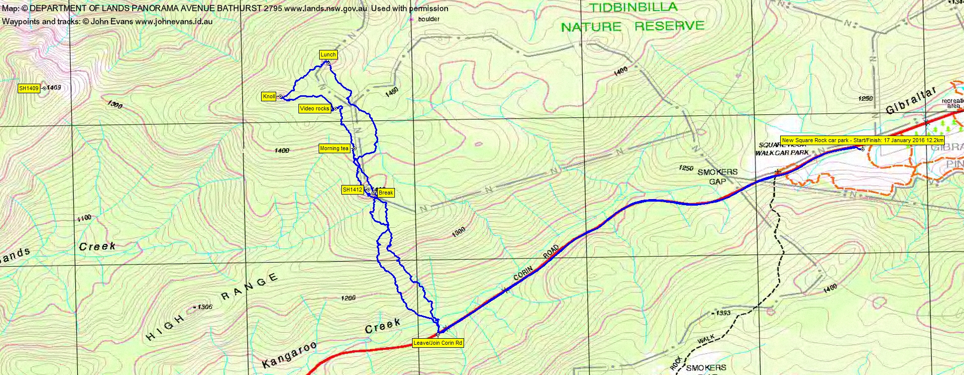
Track Map
Track
Profile
Party
6 walkers – Riddhi B, David D (leader), Trevor L, Phillip S, Keira W, me.