Sunset from Mt Tennent

Sunday 17 September: Mt Tennent sunset – M/M. Starting from Namadgi Visitors Centre at 3pm, we will follow the track up to Mt Tennent peak, diverting via Bushfold Hut subject to progress. Enjoy dinner while we watch the sunset over south Canberra and the Bimberi Wilderness, then return via the track to cars. About 15km return and 600m climb. Please bring a head torch and spare batteries, as well as your dinner! … and remember to park outside the Visitors Centre gates. Map: Williamsdale. Leader: Rowan P. Transport: Drive yourself, or contact the leader to arrange a lift. No need to book.
Further Information
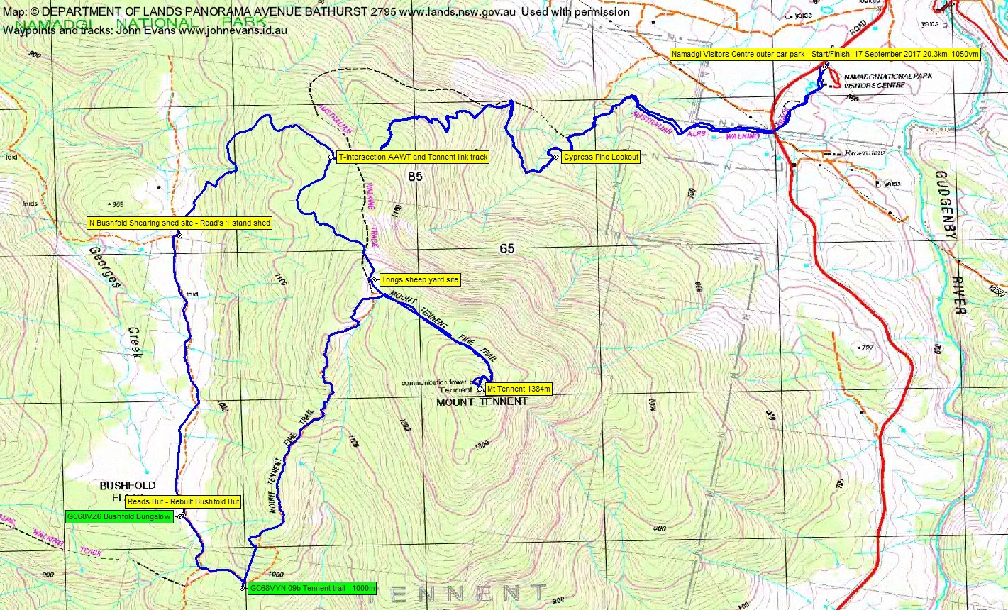
I started a little earlier and went via Bushfold Flats and the Mt Tennent Fire Trail to pick up a couple of geocaches.
Summary
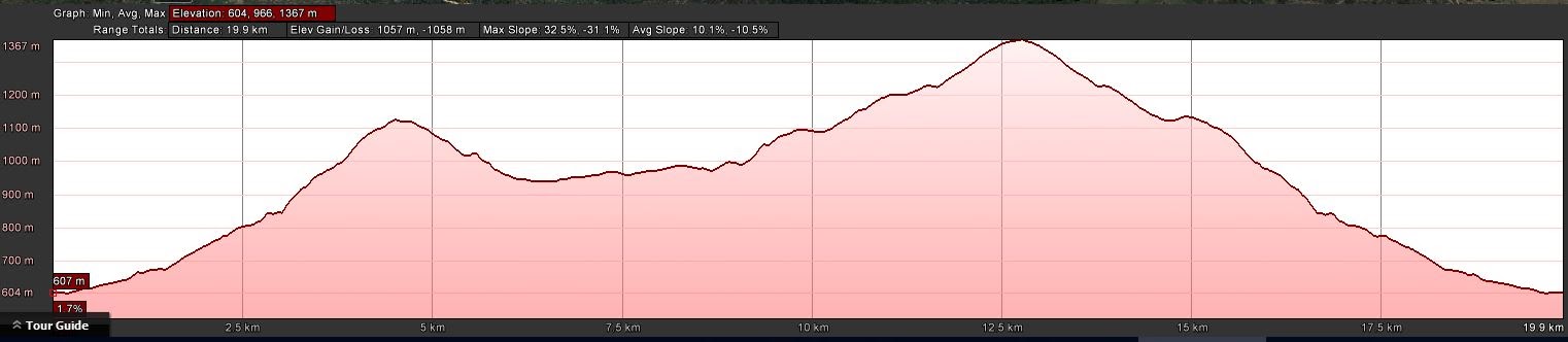
Distance: 20.3km | Climb: 1050m | Time: 1.20pm – 8.50pm (7hrs 30mins), including 90 mins of breaks | Grading: L/E; H(12)
Photographs
Photographs are available, where you can start a large sized slideshow.
Waypoint and Track Files
Download the .gpx file. (Right click, Save Link As…, Save – if you want to use it.)
To use in Google Earth, do File, Open… and select Gps or All files as the File Type.
Track Notes
It’s certainly Spring. A couple of layers on to start, but they were off by the time I reached the AAWT/Mt Tennent link T-intersection. Many out enjoying the hill – I passed 42 walkers! 1hr 15mins for this 4.6km leg.
An enjoyable downhill on the AAWT, then the nearly flat of Bushfold Flats to Bushfold Hut. 45mins for 3.8km.
Now I would have to be worse than a third rate geocacher 🙄 . No pencil. So I will have to throw myself on the mercy of today’s cache owner. There is a photo of GC68VZ6 Bushfold Bungalow’s log to prove that I was there. Out the bottom of the Flats and up the Mt Tennent ire Trail a bit. Same story at geocache GC68VYN 09b Tennent trail – 1000m. Here’s the log photo.
Then the 200vm haul up the fire trail to the link track intersection and the remaining 180vm climb to the top. I arrived at 4.50pm, a bit before Rowan’s estimated arrival time of 5.30pm.
Frickin freezing in the wind. Thermals on, down jacket on, raincoat on, neck warmer, gloves and beanie on.
The others arrived and the reason that I could not carry a pencil to sign on the caches became clear. I pulled out a fine bottle of red (well, not that fine that it didn’t need scenic enhancement), 6 rose-coloured wine goblets (plastic, to be carried home by users) and a packet of honey soy chicken chips. So I just had no capacity to carry a pencil. Other goodies were also shared and we enjoyed the sunset in the bitter breeze and ate our tea.
We left at 6.20pm and covered the 7.2km down in 2hrs 30mins. A few caterpillar stops. Once we were out of the breeze, it was a lovely mild evening. Only got cold down towards the bottom. I love night walking! You just need to be a bit slower and more deliberate, it’s harder to to judge distances and lifting your feet is wise.
Fabulous idea Rowan. Thanks. A great party and a great party 🙂 .
Track Maps


Party
6 walkers – Bernadette B, Maurie D, Lisa Q, Rowan P (leader), Kerstin W, me.